Article

Hydrogeological Analysis Supported by Remote Sensing Methods as A Tool for Assessing the Safety of Embankments (Case Study from Vistula River Valley, Poland)

Department of Geotechnical Engineering, Faculty of Civil and Environmental Engineering, Warsaw University of Life Sciences (WULS-SGGW), Nowoursynowska 159 St., 02-776 Warsaw, Poland
*
Author to whom correspondence should be addressed.
Water 2019, 11(2), 266; https://doi.org/10.3390/w11020266
Submission received: 4 January 2019 / Revised: 30 January 2019 / Accepted: 31 January 2019 / Published: 3 February 2019
(This article belongs to the Section Hydrology)

Abstract

:
We aim to answer a question: how does the evolution of fluvial environment affect to risk of embankments failure in lowland rivers and how can we identify and describe places at risk of levees failure using the remote sensing data? The study was carried out in the Vistula River valley near Magnuszew (middle Vistula course, central Poland). 24 geological boreholes were drilled to a depth of 2.0–8.5 m and groundwater table observations were conducted in a monitoring network consisting of 22 wells, 5 piezometers (screened within the Holocene alluvial aquifer) and 2 temporary water gauges. Identification of the diversity of the geological structure of the floodplain was supported by airborne laser scanning imaging, as well as high resolution satellite images and aerial photos. This remote sensing study allowed the creation of a conceptual model of hydrogeological conditions. Study takes into account the effects of the land forming activity of flood waters resulting from the evolution of the fluvial environment in the Holocene. Created conceptual model subsequently fed into the construction and calibration of a mathematical groundwater flow model using MODFLOW software. The study allowed the identification and characterisation of intensified groundwater flow zones. Concentrated flow in the substrate of flood protection levees constitutes a threat to their stability. Documented in many publications climate change will induce in future climate scenarios an increase in rainfall and prolongation of dry periods. The implementation of the methodology of identifying the geological forms with the use of presented techniques allows the identification of sections of flood embankments potentially at risk of failure.

1. Introduction

The hydrological regime is the basic factor shaping the economic and natural value of river valleys [1]. An important element is the conditions of groundwater occurrence and flow. Although river valleys generally play a draining function in the river circulation system within a river basin [2], however, on a local scale, the hydrogeological regime can show some specificity with regard to the conditions of operation of engineering facilities [3].
This specificity in the area of the Europe Lowlands is primarily due to the specific geological structure of the valleys. It is an effect of, among others, the complex evolution of their bottoms, proceeding since the decline of the Pleistocene [4,5]. The current nature of river valleys is the result of the evolution of the fluvial environment in the Holocene [6] Originally during the Holocene climate optimum, during the Atlantic period of Holocene the rivers of Europe Lowland characterized a balance between aggradation and degradation processes, the effect of which is the formation of meandering channels; characteristic of mature rivers [7]. Currently, due to changes caused by anthropopressure, in particular deforestation and management of the catchment, we note an additional supply of clastic material to the rivers. The result is the process of “re-wilding” of the rivers [8]. That is, changing their character from meandering to braided [9]. The evolution of the fluvial environment continues, as evidenced by the increase in the differences between the extreme high and low water levels [10]. This results in increased flooding depths of channel alluvials during freshets. It causes the increase of the influence of the alluvium substrate on the dynamics of contemporary channel processes [11]. The difficult-to-washable and weak-permeable base of alluvies exposed during floods stabilizes the mainstream system in successive flood surges, as a result of which out-of-batch flows constantly transform the same zones. In this way, the geological structure of the flood plain changes and the diversity of groundwater flow conditions within the alluvial series changes [12].
The conditions of groundwater flow in contemporary river valleys undergo changes related primarily to the development of their areas. In particular, in many valleys in the Europe Lowlands, the contemporary river bed zone has been separated from the remaining part of the floodplain by floodbanks (embankments). During periods of high water, the groundwater flow in alluvia forming the substrate of a floodbank may proceed under conditions of hydraulic gradients significantly higher than usual, which seems to be the main cause of filtration deformations of soils, causing failures of such structures [13].
A report of the U.S. Department of the Interior Bureau of Reclamation (U.S. DIRB) (2007), titled “Reclamation Managing Water in the West,” states that about half of earth embankment failures occur as a result of processes related to inner erosion and piping. It is also confirmed by observations of other researchers (e.g., [14,15,16,17,18,19,20]). Approximately 30% of all piping events cited in the U.S. DIRB report were caused by the washing out of soil in the foundation of the structure. The repetitiveness of these types of failures in specific locations [12] also allows associating their cause with the specifics of the geological structure of such zones and the resulting diversity of groundwater flow conditions in an alluvial aquifer (e.g., [3,21]).
The dynamic development of remote sensing techniques based on airborne and satellite imagery in spectres reaching beyond the visible bandwidth, as well as measurement techniques based on laser scanning (ALS), enable the acquisition of high resolution data involving, for example, the morphology and dynamics of processes shaping the images of floodplains (e.g., [22,23,24]). Combined with the capabilities of the GIS software [25] and tools for mathematical modelling of groundwater filtration processes, these techniques enable the performance of advanced analyses of the spatial distribution of specific parameters characterising the hydrogeological environment and the very dynamics of the water filtration process in alluvial aquiferous strata [26].
The purpose of the presented research was both to determine to what extent modern river activity affects water circulation in the alluvial aquifer in the condition of fluvial environment evolution and to define the usefulness of remote sensing data in the construction of numerical models of groundwater percolation in the substrate and near flood protection structures. Particular attention has been paid to identifying the specificity of groundwater flow conditions in the alluvial layer, which can promote the initiation and development of suffosion and internal erosion, the phenomena that threaten the stability of these structures (Figure 1).

2. Materials and Methods

2.1. An Outline of the Development of River Valleys in the Area of the Polish Lowlands

In the area of the Polish Lowlands, the geological structure of river valleys is an effect of, among other things, the polygenesis of their sections and the complex evolution of their bottoms, proceeding since the end of the Pleistocene [4,5]. The end of the Pleistocene was manifested in the fluvial environment of the Polish Lowlands by the filling of valleys by bed-load-laden braided rivers [8]. A precondition for the large supply of bed-load material to river channels was the lack of a tight vegetation cover and the presence of long-term permafrost. Under such conditions, surface runoff was the main source of river feeding. A climate warming at the beginning of the Holocene led to the disappearance of permafrost and to the expansion of forests into the catchment area [4]. The increased retention capacity of the catchment area resulted in an increase in underground outflow and eventually in the unification of flow rates in river channels and a decrease in the supply of bed-load material. Meandering rivers of the Holocene incised into pre-existing surfaces by creating their lower accumulation levels in the valleys [27,28,29]. The dissected Pleistocene accumulation levels currently form a system of upper terraces in the river valleys of the Polish Lowlands [30].
The unification of river flow rates in the Holocene due to limited surface runoff has found its reflection not only in the shape of river channels (most rivers in the Polish Lowlands were of the meandering type) but also in the specific lithological variability of floodplain sediments. River channel clastics are overlain by a layer of loamy flood sediments. Sediments of this type attain a thickness of 7 metres in the Middle Vistula River valley [8]. Those parts of the river channel which were cut off due to meandering were the areas of the accumulation of organic sediments intercalated with mineral sediments deposited from the water flowing into a depression during flood surges.
The next evolutionary stage of river valleys in the Polish Lowlands, dating back to the Subatlantic period of the Holocene, is related to human activity. The need to increase food production and industrial goods has resulted in the thinning of forests and the introduction of root crops [4,8,31]. These measures accompanied by the expansion of developed areas have led to an increase in surface runoff [32] and consequently to an increased supply of clastics to river channels that gradually transformed from meandering into braided [4,8,33]. Sediment-laden rivers formed a new braided belt within the floodplain. Rapid flood surges, which were higher than those in the meandering rivers of the Holocene climatic optimum, have also transformed to a varying degree the remaining part of the floodplain [34,35]. The process of the transformation of valleys due to human economic activity is sometimes referred to as the “wilding of rivers” [4].
The continuing evolution of the fluvial environment has probably been accelerated by climatic changes [36,37]. It is manifested by a further increase in the differences between extreme (maximum and minimum) flows [38].
The increase in maximum flows has highlighted the impact of geological structure on water circulation conditions in the alluvial layer of the individual sections of river valleys. Due to the relatively short period of their formation (since the vanishing of the last ice sheet in the given part of the Polish Lowlands), erosional bases in the valleys are not fully developed. In areas where the sub-alluvial bedrock is composed of more erosion-resistant sediments (cohesive or coarse-grained), their top currently forms morphological protrusions [21]. Their surface, exposed (from the alluvia cover) on the river channel bottom during floods (cf. [39]), influenced the high waters flow directions on the floodplain surface [21,34]. The repetition of such events in a certain part of the floodplain might lead to its transformation along with the transformation of groundwater flow condition of the alluvial aquifer.

2.2. Geological Conditions of the Research Area

A part of the Middle Vistula River valley was selected for a detailed study. It stretches upstream of Warsaw near the village of Magnuszew (Figure 2). The studied area spanned ca. 50 km2. Hydrogeological investigations were concentrated within the floodplain area, west of the river channel. The test area is delimited in the north by the Pilica River and in the south by the edge of Pleistocene terrace which neighbours here, in the vicinity of Ostrów (Figure 2) within the Vistula channel. The river valley near Magnuszew is ca. 10 km wide. Its relief is clearly pronounced by the Pleistocene upper terrace and the Holocene floodplain [40].
Bedrock strata in the part of the valley near Magnuszew, where the study area is located, are represented by Neogene (Pliocene) lacustrine clays, early Pleistocene sediments of the so-called Preglacial Series [41] composed of sands and gravels and Pleistocene morainic sediments of several glaciations. Their surface is covered with residual lag sediments. Mutual hypsometric relationships between the top surfaces of these sediments prove that the whole series has been deformed by glacial tectonics [21].
Outside the Vistula River channel zone, where the top of the sub-alluvial bedrock occurs at an elevation of 94 m a.s.l., its surface descends to a level below 85 m a.s.l. The river channel alluvia of the Pleistocene Vistula River, forming the terrace (PT in Figure 3), reach ca. 50 metres in thickness [41]. These are medium and fine sands with gravely interlayers. The surface of the terrace is covered by aeolian sands forming single, isolated dunes.
On the surface of the study area one can distinguish a zone formed by the meandering river, with clear signs of river channel migration and abandoned arched channels distinctly visible in satellite and aerial images (FM, Figure 3), as well as a modern floodplain zone adjoining the river channel, which was formed by the braided river (FC, Figure 3) [34]. The flood sediments of the floodplain show a distinct dichotomy. A discontinuous layer of laminated silty flood sediments of the contemporary river often overlies loamy sediments deposited during the meandering period. In places, where concentrated flows of flood waters took place, loamy deposits have been eroded and replaced by silty sands. Crevasse splay-type sandy and silty-sandy alluvial fans [42,43] occur locally on the floodplain surface (CS1 and CS2, Figure 3). Waters of concentrated flood flows of the contemporary river have led to partial filling of the abandoned channels with sandy sediments.

2.3. Field and Remote Sensing Studies

As part of field work, 24 geological 2.0–8.5 m deep boreholes were drilled using an Eijkelkamp case drilling set (Figure 2). Seventeen geological probes with a depth of up to 2 metres were also made. During work, samples of alluvial materials were collected for laboratory testing.
Groundwater table observations were also conducted in a monitoring network which consisted of 22 wells and 5 piezometers installed for the needs of the study (Figure 2). The piezometers were screened within the Holocene alluvial aquifer. 10 temporary water gauges installed in the Vistula channel, oxbows and lakes in the boundaries of the tested area supplemented the monitoring system (Figure 2). The frequency of groundwater table measurements in the monitoring network was dependent on water level in the river. During flood flows, the measurements were made every 1 hour, while under low and moderate water level conditions they were made once every 2 weeks. Hydrogeological mapping was also performed in selected zones of the test area. The occurrence of leakage and springs, as well as water level position in natural and artificial depressions on the floodplain area, was registered.
The locations of survey points were established and their levelling surveys were carried out with a Topcon GPS RTK set (GRS-1, Topcon Positioning System Inc., Livermore, CA, USA). Horizontal accuracy amounted to 0.03 m and vertical accuracy 0.05 m.
Laboratory studies included grain-size analyses of soil samples and the determination of the Darcy coefficient of permeability.
For the analysis the GIS database was developed. We used ArcGIS version 10 software (Esri, Redlands, CA, USA). The database in the beginning contained: (i) geological/hydrogeological materials from the archives of the National Geological Survey, (ii) cartographic materials from the Central Archives of Geodetic Documentation (including also Digital Terrain Model (DTM) from airborne LIDAR scanning; the average interpolation error of the contour lines in the model was 0.2 m), (iii) records of floodbanks failure events from the archives of the managing authority of the Middle Vistula River section, that is, the Regional Water Management Authority in Warsaw, (iv) satellite images provided by the IKONOS 2 satellite (DigitalGlobe Inc., Westminster, CO, USA), (v) monochromatic aerial images of the analysed section of the river valley that were made in 1990 to a scale of 1:16000.

2.4. Modelling Studies

The results of mathematical modelling of groundwater flow were used to identify the characteristics of the shallow groundwater circulation system in the study area, including the conditions of groundwater recharge, drainage and flow balance. For this purpose, the Visual MODFLOW software package (ver. 2009.1) from Waterloo Hydrogeologic Inc. (Kitchener, ON, Canada) was used [44]. The models of hydrogeological systems are presented in this package in the form of general differential equations that are solved by the finite difference method (FDM) [44].
The creation of the numerical model of groundwater flow (Figure 4) requires not only establishing the boundary and initial conditions but also introducing the values of hydrogeological parameters that characterise individual components of the modelled area. MODFLOW allows setting a constant value of a given parameter for both the entire layer and its selected fragment. The basic parameter introduced into the model is the permeability coefficient that characterises the water permeability of the modelled medium. In this model, the parameter has been differentiated within the individual layers according to the values obtained from both own laboratory tests and results of previous studies conducted by other authors.
During the modelling, three types of boundary conditions were used. The type I condition was applied at the southern border of the area. The remaining boundaries were simulated in the axis of surface watercourses by the type III condition. The type II condition was used to transfer effective infiltration. The research included implementation and calibration using the monitoring data of a steady-state flow model, followed by the development and verification of a transient model. In the calibration process, 25 groundwater table measurements were taken into account, which were then compared with values calculated by means of iterative methods. The base model was considered calibrated with an average nRMS error at a level of 16.1%.

3. Results

The conducted field work, laboratory tests and analyses of historical data enabled the creation of a conceptual model of geological structure and hydrogeological conditions. This model takes into account the hydrogeological specificity of the studied part of the valley, which results from its morphogenesis.

3.1. The Results of Field and Remote Sensing Data Analyses

The presented studies have enabled the identification of elements important for the groundwater dynamics of the alluvial aquifer within the floodplain area, which have not been described in this context in other studies. Landforms were identified during field research and by analysing remote sensing materials (Figures 3 and 5).
These are:
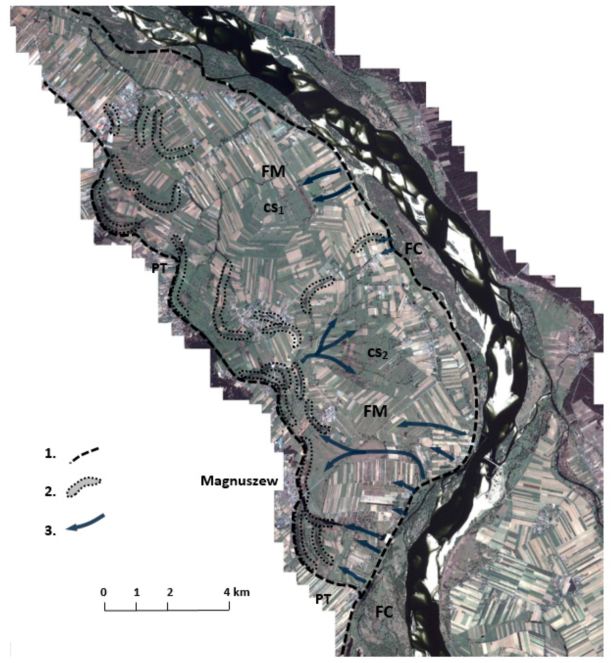
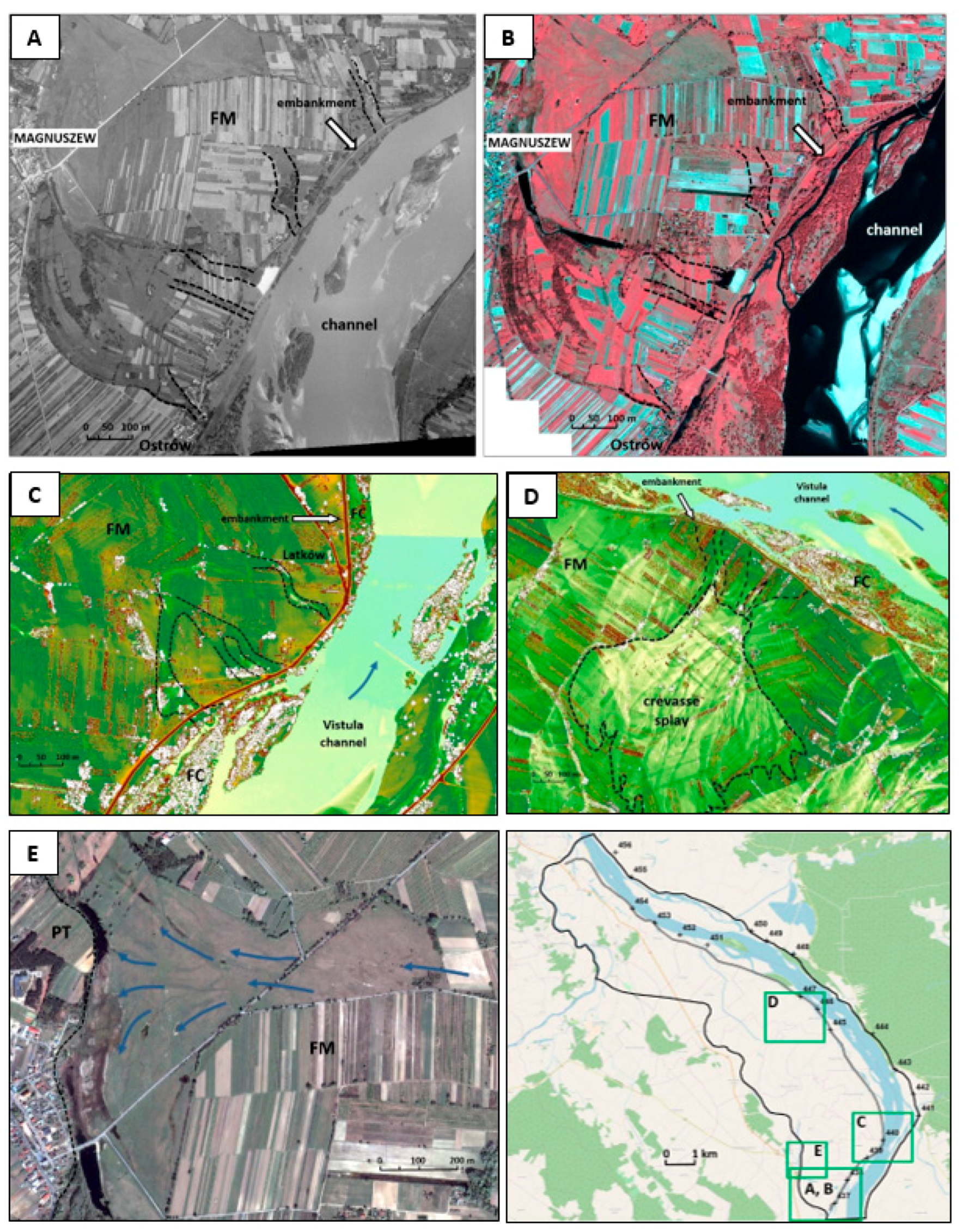
  • Crevasses. These landforms are found in a zone adjoining the river channel. They were formed as a result of the concentrated flow of flood waters breaking through the natural levee zone (the proximal part of the floodplain) [45,46]. In total, six such landform zones have been identified in the test area (Figure 3). The depths of these incisions range from 1 m in the northern part of the test area to over 8 m near the village of Ostrów (southern part of the test area, at km 439 of the river course). These landforms have lengths of 30 to 250 m. They are filled with medium and coarse sands. Although the secondarily sediment-filled crevasses are often minor depressions in the floodplain area, their course is clearly visible on its surface in the ALS (DTM) image (Figure 5).
  • These landforms are perpendicular or oblique to the course of the Vistula River channel. The bottom surface of sediment-filled crevasses is clearly visible using both near-infrared (NRG) satellite imagery and monochrome aerial photography (Figure 5A,B).
  • Secondarily sediment-filled flood flow channels and abandoned channels (oxbow lakes). These landforms are located mostly at the foot of the Pleistocene terrace scarp, in the western part of the test area (Figure 2, Figure 5E). The oxbow lakes are up to 5 m deep, while the flood erosion channels are no more than 2 m deep. They are filled mainly with medium sands with rare interlayers of silt and organic matter. The shoreline of these landforms is easy to identify and shows a characteristic relief decipherable in satellite images (the deposition process was of deltaic type; comp. [34]) (Figure 5E)). The relief of these surfaces, however, is poorly recognisable in DTM images.
  • Alluvial fans (crevasse splays) are composed of sands and silts with a maximum thickness of ca. 2.2 m. The analysed remote sensing materials clearly show their fingerlike shapes. Both aerial photographs and near-infrared imaging (Figure 5D) emphasise the difference in moisture between the crests of ridges that build these landforms and the depressions between them, which are also locally lined with a thin layer of alluvial muds.
  • The floodplain surface, bearing the traces of meanders (FM), is composed of loamy flood sediments. The satellite and aerial images show its homogeneous surface with recognisable traces of meandering river channel migration (Figure 3). The lower legibility of these landforms in the images indicates the presence of a silt cover on the surface, associated with recent (before the construction of floodbanks) transformation by the flood flows.
  • The channel zone surface (proximal floodplain) is characterised by high phototonal diversity in both monochrome aerial photographs and satellite images (Figure 3 and Figure 5). This emphasises the variation in moisture between the levee crests (which are sandy and often lacking vegetation) and the zones between them, which are lined with a silty material with an admixture of organic matter. The boundaries of the levees of the modern braided river are particularly evident in laser scanning imaging (DTM).

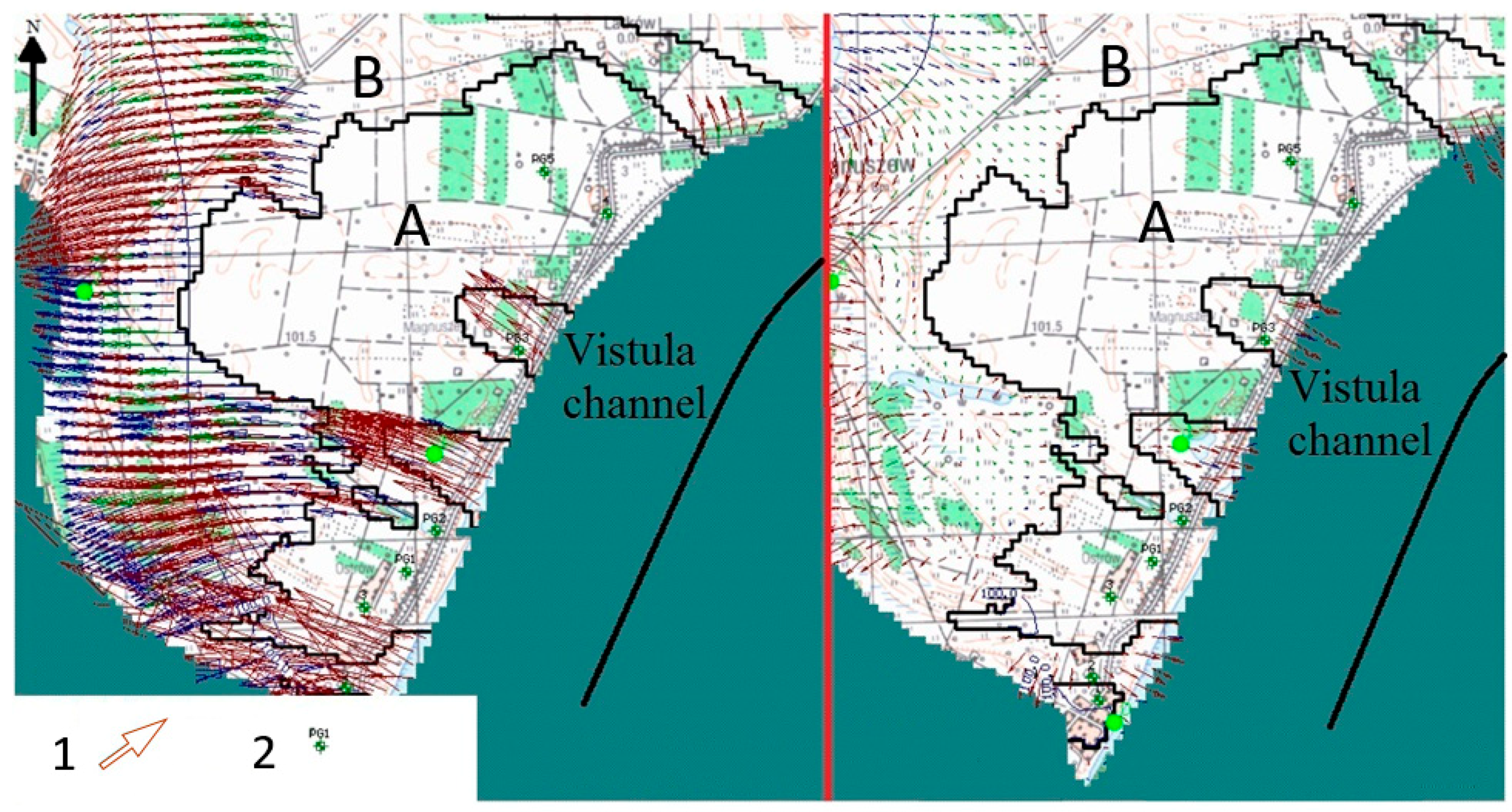
3.2. Hydrogeological Analyses and Modelling Studies

The groundwater circulation model consists of two aquifers in the Quaternary aquifer formation. These are:
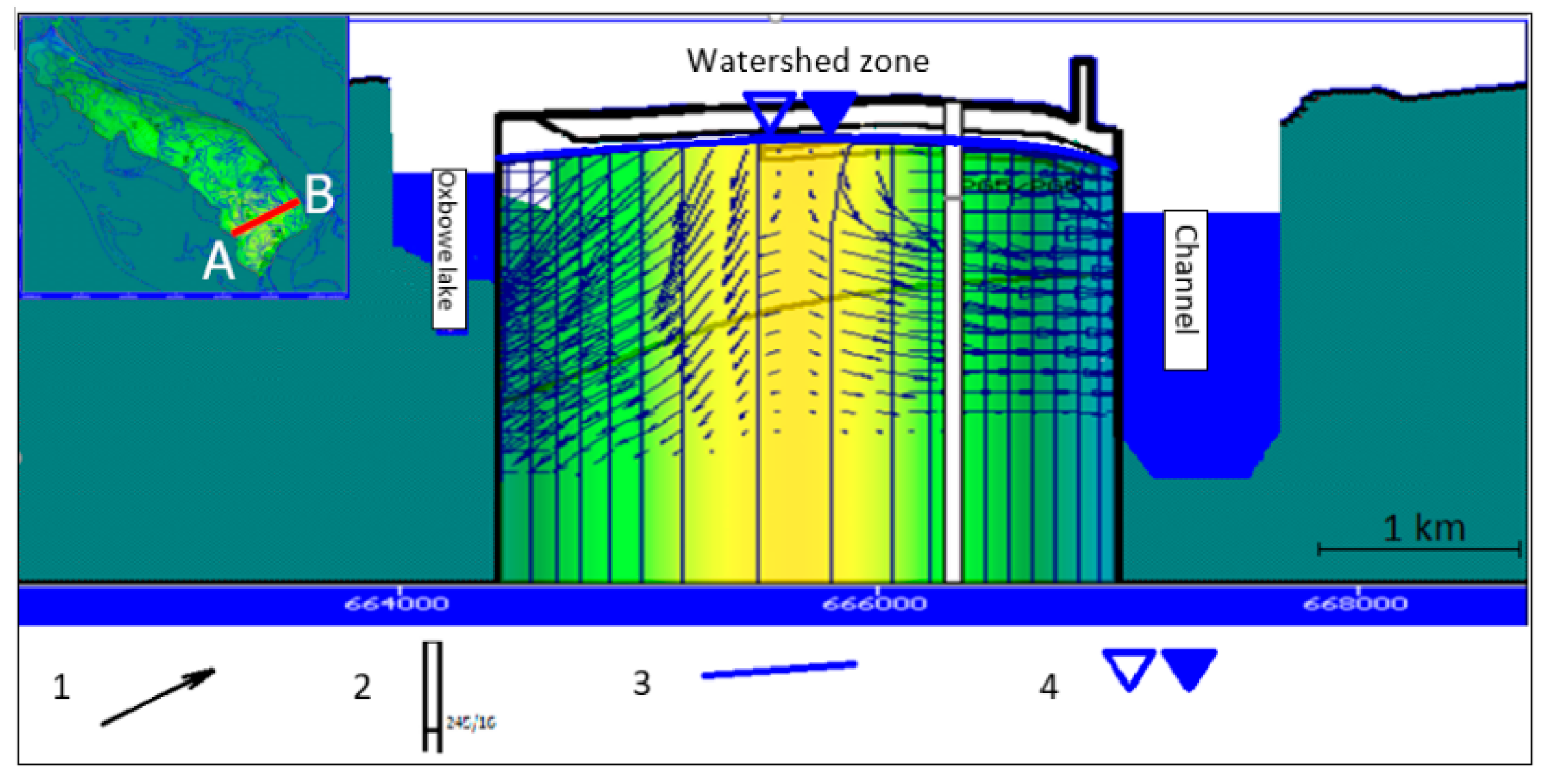
  • A near-surface aquifer, which occurs locally, built up with flood flow sediments of the modern braided Vistula River. The aquifer, up to 3 m in thickness, is composed of fine-grained sands with silty and loamy interlayers. The average value of the permeability coefficient of these sediments was determined by laboratory analyses at 8 × 10⁻⁴ m·s−1.
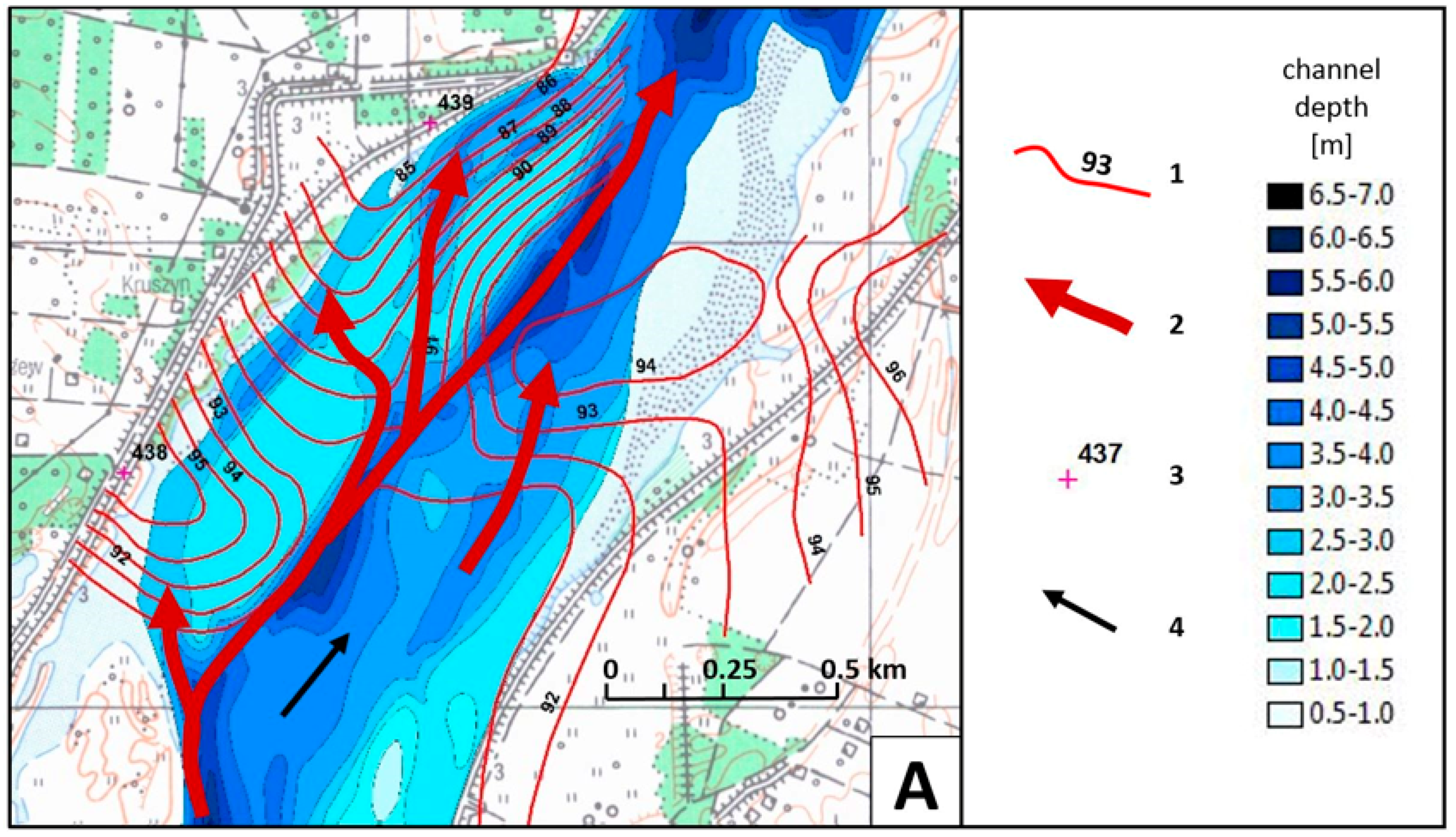
  • The second aquifer is separated from the first over a large area by a series of poorly permeable flood sediments. It is composed of unsorted sands and gravels with sands, ranging from 1.5 m to 9 m in thickness. These are channel alluvia of both the meandering and braided Vistula River. The average permeability coefficient values for sediments forming this layer, determined based on laboratory tests, ranges between 2 × 10⁻⁴ and 5 × 10⁻⁵ m·s−1.
The permeability coefficient of the deposits that built up the series of flood sediments separating these aquifers was determined at 5 × 10⁻⁸ m·s−1.
In the condition of low and medium river discharges a watershed zone stabilises in the study area (Figure 6). The eastern part of the floodplain is drained directly by the Vistula River and the western part, which is slightly narrower, by a system of inter-communicated and partly buried oxbow lakes and flood flow routes. Under the conditions of flood flows, when rivers become clearly infiltrating, the rise of the water level in the inter-embankment zone is manifested initially by the westward shift of the watershed zone and then by its waning.
Changes in water level in the inter-embankment zone are marked in a special way in places where the floodplain surface is cut by troughs of crevasses (Figure 7). In places where the flood embankment is located on the crevasse filled with the channel alluvia, along with the increase in water level in the inter-embankment zone, there is an increase in hydraulic gradient, which can reach 5–6%. This phenomenon is marked on the floodplain surface in the vicinity of the embankment by the formation of variously sized seepage zones (Figure 1).
Outside the crevasse, where the flood embankment has been set on a layer of poorly permeable flood sediments, the hydraulic gradients are distinctly smaller. The infiltrating nature of the river during flood wave passage is marked by the formation of artesian conditions in the vicinity of the embankment (Figure 7C,D).
The results of study confirmed that the presence of difficult-to-wash soil in the valley substrate causes a significant change in the dynamics of erosion and sedimentation in the flood plain. For the safety of the embankments, it seems particularly important in these zones to be present in the vicinity of the construction of erosion gutters filled with weakly compacted sediments. In these zones, the process of suffosion leading to the destruction of the embankment foundation may be initiated.

4. Discussion

The dichotomy of floodplain surface (resulting from its Holocene evolution), as well as the specificity of contemporary high water flows, are of key significance for the hydrogeological conditions of the Vistula River valley along the analysed segment.
The nature of high water erosion and deposition which took place before the construction of floodbanks may be associated with the impact of the protrusion of the sub-alluvial bedrock, which has been documented earlier in the channel zone [21,34]. In a direct manner this structure impacts the shape of the arrangement of the river currents during periods of passage of a high water wave, when its complex surface becomes uncovered from the channel alluvia layer [21] (Figure 8). The sub-alluvial bedrock protrusion can also indirectly affect the flow, since its presence favours the creation of ice jams. A comparison between the distribution of zones subject to blockages in the channel of the middle Vistula River and the position of detected sub-alluvial bedrock protrusions proved their high compliance [47]. The relative stability of ice jams, conditioning the morphogenetic effectiveness of dammed water flows on the floodplain surface, results most likely from the fact, that the blockage is based on the top of the substrate of contemporary alluvia, which is hard to wash out. These are grounded-type ice jams according to [48].
A decrease in the channel patency resulting in the damming of high water may also be related to the alluvia that pile up in the channel [49]. Such a phenomenon was described, for example, by [43]. Over the whole segment of the middle Vistula River valley (a length of approximately 250 kilometres), sub-alluvial bedrock protrusions are very frequently accompanied by permanent channel macroforms [11].
Along the analysed segment, high waters (including those from ice blockages) entering the floodplain transformed its area by removing (locally) the top part of the layer of loamy muds from the meandering period and depositing in its place a series of silty and sandy sediments. In this manner, the conditions of supplying the alluvial aquifer by infiltration have been improved. The activity of contemporary flood water flows has also led to the shaping of a new, topmost aquifer on the surface of the floodplain, consisting mainly of sediments forming crevasse splays and smaller depositional landforms. The dynamics of the creation of such zones in the area of contemporary floodplains has been described, for example, by [50,51,52].
For their flow path, contemporary flood waters also used oxbow lakes that form a series of depressions at the foot of the escarpment of the Pleistocene terrace. This flow has resulted in their partial filling with sandy sediment. In this manner, a second element draining the alluvial aquifer has been shaped, apart from the channel (along with a braided belt). Between them, a watershed zone stabilises under the conditions of medium and low water levels. However, its position changes along with a changing relation between the position of water table in the inter-floodbank zone and the level of water in the series of oxbow lakes.
Particularly significant for the current hydrogeological conditions of the analysed zone are crevasse channels (crevasses). The crevasse formation mechanism, associated with the ascent of water level in the channel, has been described, for example, by [46,51,53,54]. However, in the Magnuszew vicinity their concentration results from the interaction with the sub-alluvial bedrock [34], cf. [12].
Such landforms may have depths which are diverse in relation to the size of the river channel. This is evidenced by the observations of both ancient forms [45] and forms observed nowadays in engineered channels [12,24,50]. Crevasse channels in the analysed segment have depths of between 1 and over 8 metres. Creation of deeper forms is associated with the process of whirlpool erosion (eversion). Smaller forms are developed only within the braided belt and larger ones are cut through the layer of poorly permeable flood sediments from the meandering period of the Vistula River valley development.
Crevasse channels are filled with loose sediment of channel facies, deposited during the waning phase of the flood wave. This fact is the cause of much higher water permeability of these sediments compared to the channel alluvia forming the remaining part of the floodplain. Various generations of channel alluvia-filled crevasses may constitute privileged filtration routes within an alluvial aquifer (cf. [55]). The diversity of groundwater flow conditions, especially in the vicinity of the channel zone, is an important issue for the development of river valley bottoms. Such a feature is important in the case of the construction of riverbank filtration water intakes (cf. [56,57,58]). It has been examined, among others, by [59,60,61]. Within the study area, the filled crevasses were masked with the sediments of subsequent floods, due to which some of them are poorly pronounced in valley bottom morphology. In the case of landforms studied by [62], the sediments filling the crevasses form isolated outcrops on the valley bottom surface, which can make it difficult to trace their course. Such zones can also be masked as a result of cultivation; however, their visibility on LIDAR images is satisfactory.
The construction of floodbanks did not change water flow conditions in the alluvial aquifer in a qualitative manner but only quantitatively. Floodbanks were constructed at the edge of the braided belt, partially on the surface of a natural levee zone.
Under the conditions of both low and high water levels in the Vistula River, the zones of crevasse troughs constitute the pathways of intense (privileged) filtration (Figure 9). The cyclicity of changes in the direction of filtration within crevasses during a single flood event prevents both the densification of the soil that fills them, as well as its clogging. Such a condition favours the formation of filtration deformations in the basement of flood-protection embankment. This phenomenon constitutes a significant risk to the stability of floodbanks.
Under the conditions of increasing amount of extreme flows in future climate [63], the instinct significance will have an impact on the flow conditions of the presence of the shallow sediment of the alluvium substrate. Its presence determines the formation within the proximal zone of a flood plain of a number of geomorphological forms described above and that may have a negative impact on the safety of flood protection structures [20,32]. The implementation of the methodology of identifying the geological forms with the use of remote sensing techniques allows the identification of sections of flood embankments potentially at risk of failure.

5. Conclusions

The modelling studies have shown that floodplain landforms that developed as a result of the relief-forming activity of flood flows in the condition of fluvial environmental evolution are essential elements of the groundwater flow environment in the zone under study.
The modern river channel zone (proximal floodplain), particularly well recognisable in NRG images, is characterised by an unconfined groundwater surface in both draining and infiltrating river settings.
Zones of secondarily filled-up oxbow lakes and flood flow channels in the western part of the test area are the essential drainage element of the alluvial aquifer. The major indication of their significance is the development of a watershed zone within the floodplain during low and medium water flows in the Vistula River.
Much of the floodplain area (its distal zone) is covered by a poorly permeable layer of flood sediments. During flood flows, when the river waters lean against the flood embankment, a confined water surface can develop in the underlying layer of the channel alluvia.
Sediment-filled crevasses seem to be the most important elements of the groundwater environment in the test area in terms of floodplain management and flood safety. The origin of these landforms, in which an important role is also played by whirlpool erosion processes (evorsion), results in the formation of very deep incisions in floodplain sediments (up to 8 m; the maximum thickness of channel alluvia is ca. 12 m). The dynamics of the crevasse-filling process, which consists of the fast deposition of material carried by the river after the peak flood flow, are responsible for the low density of the sediment. Thus, hydraulic conductivity in such landforms makes them the preferred groundwater flow pathways within the alluvial aquifer. The identification of such zones is possible based on remote sensing materials. In the field, they are frequently hardly visible due to small differences in absolute elevations relative to the floodplain level.
The occurrence of sediment-filled crevasses in the substrate of floodbanks can pose a significant risk because of the high probability of development (when the waters lean against the floodbank) of inner erosion processes. In the authors’ experience, very often such zones are not recognised, because the standards in studying foundations for linear objects, such as flood protection embankments, assume discrete surveys along the planned or currently rebuilt structure. In such situations, remote sensing methods seem to be helpful.
As proved by studies in the Vistula River valley near Magnuszew, the zones of concentrated flood flows occur in the places of occurrence of sub-alluvial bedrock protrusions composed of soils relatively resistant to washing out. Their presence in the valleys of lowland rivers can result mainly from either the morphogenetic immaturity of the river valleys (the lack of a developed erosional base) or neotectonic activity. Such a situation is characteristic of river valleys in the Polish Lowlands. The relief and lithology of surface sediments is related here to the glacial history of the area. One should expect that hydrogeological conditions similar to those in the Magnuszew region could also be found in river valleys of other lowlands of glacial relief. Thus, under specific conditions, the available remote sensing techniques allow the extrapolation of geological data acquired at given survey points to be used in regional-scale contributions.
Accurate identification of the boundaries of the outcrops of individual sediments that vary in permeability parameters, performed using these techniques, highly facilitates the creation of a model of the geological structure, which can subsequently form the basis for development of a mathematical model of groundwater circulation conditions within the near-surface aquifer.
Digital groundwater flow models of a floodplain area should be used in decisions regarding the management of river valleys, especially in terms of flood safety and crisis management. I the future climate scenario a numerical model of the groundwater flow environment, which involves morphodynamic features acquired from the remote sensing techniques in the study area may become an excellent basis for determining the risk of flooding associated with the occurrence of geological uncertainty in the ground near the embankments. The technique allows in particular to determine the course of boundaries of outcrops of geological layers characterized by different geotechnical parameters. The selected zones should, however, be each time verified with the use of a classical geotechnical recognition at the stage of setting the structure of flood protection.

Author Contributions

Conceptualization, F.B. and T.F.; Methodology, F.B. and T.F.; Software, F.B. and T.F.; Validation, F.B. and T.F.; Formal Analysis, T.F.; Investigation, F.B. and T.F.; Resources, F.B. and T.F.; Data Curation, F.B. and T.F.; Writing–Original Draft Preparation, F.B. and T.F.; Writing–Review & Editing, F.B. and T.F.; Visualization, F.B. and T.F.; Supervision, T.F.; Project Administration, F.B. and T.F.; Funding Acquisition, there is no external founding.

Funding

This research received no external funding.

Acknowledgments

In this part, we would like to thank Piotr Ostrowski, Grzegorz Wierzbicki and Urszula Święcicka for help in carrying out difficult field work.

Conflicts of Interest

The authors declare no conflict of interest.

References

  1. Kundzewicz, Z.W.; Lugeri, N.; Dankers, R.; Hirabayashi, Y.; Döll, P.; Pińskwar, I.; Dysarz, T.; Hochrainer, S.; Matczak, P. Assessing river flood risk and adaptation in Europe—Review of projections for the future. Mitig. Adapt. Strateg. Glob. Chang. 2010, 15, 641–656. [Google Scholar] [CrossRef]
  2. Freeze, H.; Whitherspoon, R. Theorethical Analysis of Regional Groundwater Flow. Water Resour. Res. 1967, 3, 623–634. [Google Scholar] [CrossRef]
  3. Bujakowski, F. Morphogenetic Criteria for Identification of Filtration Variability in an Alluvial Layer Based on the Example of the Middle Vistula Valley. Ph.D. Thesis, WBiIŚ SGGW, Warszawa, Poland, 2015. [Google Scholar]
  4. Starkel, L. The reflection of hydrologic changes in fluvial environment of the temperate zone during the last 15,000 years. In Background to Paleohydrology; Gregory, J., Ed.; J. Wiley: Chichester, UK, 1983; pp. 213–234. [Google Scholar]
  5. Vandenberghe, J. The relation between climate and river processes, landforms and deposits Turing the Quaternary. Quat. Int. 2002, 91, 17–23. [Google Scholar] [CrossRef]
  6. Wierzbicki, G.; Ostrowski, P.; Falkowski, T.; Mazgajski, M. Geological setting control of flood dynamics in lowland rivers (Poland). Sci. Total Environ. 2018, 636, 367–382. [Google Scholar] [CrossRef] [PubMed]
  7. Falkowski, E. Historia i prognoza rozwoju układu koryta wybranych odcinków rzek nizinnych Polski. Biuletyn Geologiczny 1971, 12, 5–121. [Google Scholar]
  8. Falkowski, E. Variability of channel processes of lowland rivers in Poland and changes of Valley floors during Holocene. Biuletyn Geologiczny Uniwersytetu Warszawskiego 1975, 19, 45–78. [Google Scholar]
  9. Falkowski, T. Alluvial bottom geology inferred as a factor controlling channel flow along the Middle Vistula River, Poland. Geol. Q. 2007, 51, 91–102. [Google Scholar]
  10. Starkel, L. Change in the frequency of the extreme events as the indicator of climatic change In the Holocene (in fluvial systems). Quat. Int. 2002, 91, 25–32. [Google Scholar] [CrossRef]
  11. Falkowski, T. Factors of Natural Stability of the Middle Vistula Channel Zones; Wydawnictwo SGGW: Warszawa, Poland, 2006; 128p. (In Polish) [Google Scholar]
  12. Wierzbicki, G.; Ostrowski, P.; Mazgajski, M.; Bujakowski, F. Using VHR multispectral remote sensing and LIDAR data to determine the geomorphological effects of overbank flow on a floodplain (the Vistula River, Poland). Geomorphology 2013, 183, 73–81. [Google Scholar] [CrossRef]
  13. Sokołowski, J.; Mosiej, K. Evaluation of embankments after the 1997 flood. In Proceedings of the Science and Technology-Flood Forum, Ustroń, Poland, 10–12 September 1997. (In Polish). [Google Scholar]
  14. Terzaghi, K. Theoretical Soil Mechanics; Chapman and Hall, Limited: New York, NY, USA, 1943. [Google Scholar]
  15. Sieczka, A.; Garbulewski, K. Limit state of hydraulic damage HYD in earth dams according to Eurocode 7. Sci. Rev. Eng. Environ. Shap. 2014, 23, 63. (In Polish) [Google Scholar]
  16. Wett, B.; Jarosch, H.; Ingerle, K. Flood induced infiltration affecting a bank filtrate well at the River Enns, Austria. J. Hydrol. 2002, 266, 222–234. [Google Scholar] [CrossRef]
  17. Richards, K.S.; Reddy, K.R. Critical appraisal of piping phenomena in earth dams. Bull. Eng. Geol. Environ. 2007, 66, 381–402. [Google Scholar] [CrossRef]
  18. Wierzbicki, G.; Ostrowski, P.; Samulski, M.; Bujakowski, F. The impact of geological setting into a dynamics of extreme floods—A case study of the 2010 flood event in the Vistula valley. Infrastruktura i Ekologia Terenów Wiejskich 2012, 3, 27–41. (In Polish) [Google Scholar]
  19. Kledyński, Z. Failure and catastrophe of a hydrotechnic facility. Nowoczesne Budownictwo Inżynieryjne 2012, 10, 32–35. (In Polish) [Google Scholar]
  20. Foster, M.; Fell, R.; Spannagle, M. The statistics of embankment dam failures and accidents. Can. Geotech. J. 2000, 37, 1000–1024. [Google Scholar] [CrossRef]
  21. Falkowski, T. The application of geomorphological analysis of the Vistula River, Poland in the evaluation of the safety of regulation structures. Acta Geol. Pol. 2007, 57, 377–390. [Google Scholar]
  22. Remo, J.W.; Ryherd, J.; Ruffner, C.M.; Therrell, M.D. Temporal and spatial patterns of sedimentation within the batture lands of the middle Mississippi River, USA. Geomorphology 2018, 308, 129–141. [Google Scholar] [CrossRef]
  23. Byun, Y.; Han, Y.; Chae, T. Image fusion-based change detection for flood extent extraction using bi-temporal very high-resolution satellite images. Remote Sens. 2015, 7, 10347–10363. [Google Scholar] [CrossRef]
  24. Yuill, B.T.; Khadka, A.K.; Pereira, J.; Allison, M.A.; Meselhe, E.A. Morphodynamics of the erosional phase of crevasse-splay evolution and implications for river sediment diversion function. Geomorphology 2016, 259, 12–29. [Google Scholar] [CrossRef]
  25. Wang, B.; Xu, Y.J. Dynamics of 30 large channel bars in the Lower Mississippi River in response to river engineering from 1985 to 2015. Geomorphology 2018, 300, 31–44. [Google Scholar] [CrossRef]
  26. Sieczka, A.; Bujakowski, F.; Falkowski, T.; Koda, E. Morphogenesis of a Floodplain as a Criterion for Assessing the Susceptibility to Water Pollution in an Agriculturally Rich Valley of a Lowland River. Water 2018, 10, 399. [Google Scholar] [CrossRef]
  27. Kozarski, S.; Rotnicki, K. Valley floors and changes of river channel patterns in the North Polish Plain during the Late-Würm and Holocene. Quaest. Geogr. 1977, 4, 51–93. [Google Scholar]
  28. Mycielska-Dowgiałło, E. The Development of the Fluvial Sculpture of the Northern Part of the Sandomierz Basin in the Light of Sedimentological Research; Wydaw-a UW: Warszaw, Poland, 1978; Volume 120. (In Polish) [Google Scholar]
  29. Szumański, A. Postglacial evolution and the mechanism of transformation of the bottom of the Lower San Valle. Zeszyty Naukowe AGH Geologia 1986, 12, 5–92. (In Polish) [Google Scholar]
  30. Mojski, J.E. Polish Lands in the Quaternary: Outline of Morphogenesis; Polish Geological Institute: Warsaw, Poland, 2005. (In Polish)
  31. Bissolli, P.; Friedrich, K.; Rapp, J.; Ziese, M. Flooding in eastern central Europe in May 2010—Reasons, evolution and climatological assessment. Weather 2011, 66, 147–153. [Google Scholar] [CrossRef]
  32. Łajczak, A.; Plit, J.; Soja, R.; Starkel, L.; Warowna, J. Changes of the Vistula river channel and floodplain in the last 200 years. Geogr. Pol. 2006, 79, 65–87. [Google Scholar]
  33. Nanson, G.C.; Croke, J.C.A. Genetic classification of floodplains. Geomorphology 1992, 4, 459–486. [Google Scholar] [CrossRef]
  34. Falkowska, E.; Falkowski, T. Trace metals distribution pattern in floodplain sediments of a lowland river in relation to contemporary valley bottom morphodynamics. Earth Surf. Process. Landf. 2015, 40, 876–887. [Google Scholar] [CrossRef]
  35. Cyberski, J.; Grześ, M.; Gutry-Korycka, M.; Nachlik, E.; Kundzewicz, Z.W. History of floods on the River Vistula. Hydrol. Sci. J. 2006, 51, 799–817. [Google Scholar] [CrossRef] [Green Version]
  36. Kundzewicz, Z.W. Climate change track in river floods in Europe. Proc. IAHS 2015, 369, 189–194. [Google Scholar] [CrossRef] [Green Version]
  37. Blöschl, G.; Hall, J.; Parajka, J.; Perdigão, R.A.P.; Merz, B.; Arheimer, B.; Aronica, G.T.; Bilibashi, A.; Bonacci, O.; Borga, M.; et al. Changing climate shifts timing of European floods. Science 2017, 357, 588–590. [Google Scholar] [CrossRef] [Green Version]
  38. Knox, J.C. Sensitivity of modern and Holocene floods to climate change. Quat. Sc. Rev. 2000, 19, 439–457. [Google Scholar] [CrossRef]
  39. Leopold, L.B.; Wolman, M.G.; Miller, J.P. Fluvial Processes in Geomorphology; WH Freeman & Co.: San Francisco, CA, USA, 1964; pp. 1–522. [Google Scholar]
  40. Sarnacka, Z. Detailed Geological Map of Poland, Sheet Magnuszew; Wydawnictwa Geologiczne: Warsaw, Poland, 1980. (In Polish)
  41. Różycki, S.Z. Pleistocene of the Central Poland against the Background of the Late Tertiary; PWN: Warszawa, Poland, 1972; pp. 1–316. (In Polish) [Google Scholar]
  42. Bridge, J.S. Rivers and Floodplains—Forms, Processes, and Sedimentary Record; Blackwell: Oxford, UK, 2003; 491p. [Google Scholar]
  43. Pierce, A.R.; King, L.S. Spatial dynamics of overbank sedimentation in floodplain systems. Geomorphology 2008, 100, 256–268. [Google Scholar] [CrossRef]
  44. McDonald, M.G.; Harbaugh, A.W. A modular three-dimensional finite difference groundwater flow model. In Book 6, Modeling Techniques; US Geological Survey: Reston, VA, USA, 1988. [Google Scholar]
  45. Miall, A.D. The Geology of Fluvial Deposits: Sedimentary Facies, Basin Analysis and Petroleum; Springer: Berlin/Heidelberg, Germany, 1996; pp. 1–582. [Google Scholar]
  46. Nelson, S.A.; Leclair, S.F. Katrina’s unique splay deposits in a New Orleans neighborhood. GSA Today 2006, 16, 4. [Google Scholar] [CrossRef]
  47. Falkowski, T.; Popek, Z. Zones of the ice-jam formation on the Middle Vistula River reach in relation to variable of river valley morphology. Ann. Warsaw Agric. Univ. Land Reclam. 2000, 30, 77–90. [Google Scholar]
  48. Williams, G.P.; MacKay, D.K. The characteristics of ice jams. In Seminar on Ice Jams in Canada, Technical Memorandum; National Research of Canada: Ottawa, ON, Canada, 1973; Volume 107, pp. 17–35. [Google Scholar]
  49. Falkowski, T.; Ostrowski, P.; Siwicki, P.; Brach, M. Channel morphology changes and their relationship to valley bottom geology and human interventions: A case study from the Vistula Valley in Warsaw, Poland. Geomorphology 2017, 297, 100–111. [Google Scholar] [CrossRef]
  50. Gębica, P.; Sokołowski, T. Sedimentological interpretation of crevasse splays formed during the extreme 1997. flood in the upper Vistula River Valley (south Poland). Annales Societatis Geologorum Poloniae 2001, 71, 53–62. [Google Scholar]
  51. Arnaud-Fassetta, G. Dyke breaching and crevasse-splay sedimentary sequences of the Rhône Delta, France, caused by extreme river-flood of December 2003. Geografia Fisica e Dinamica Quaternaria 2013, 36, 7–26. [Google Scholar]
  52. Li, J.; Bristow, C.S. Crevasse splay morphodynamics in a dryland river terminus: Río Colorado in Salar de Uyuni Bolivia. Quat. Int. 2015, 377, 71–82. [Google Scholar] [CrossRef]
  53. Coleman, J.M. Brahmaputra River: Channel processes and sedimentation. Sediment. Geol. 1969, 3, 129–239. [Google Scholar] [CrossRef]
  54. Allen, J.R.L. Physical Processes of Sedimentation; George Allen and Unwin LTD.: London, UK, 1970; 248p. [Google Scholar]
  55. Jung, M.; Burt, T.P.; Bates, T.P. Toward a conceptual model of floodplain water table response. Water Resour. Res. 2004, 40, W12409. [Google Scholar] [CrossRef]
  56. Shankar, V.; Eckert, P.; Ojha, C.; König, C.M. Transient three-dimensional modelling of riverbank filtration at Grind well field, Germany. Hydrogeol. J. 2009, 17, 321–326. [Google Scholar] [CrossRef]
  57. Ulrich, C.; Hubbard, S.S.; Florsheim, J.; Rosenberry, D.; Borglin, S.; Trotta, M.; Seymour, D. Riverbed clogging associated with a California riverbank filtration system: An assessment of mechanisms and monitoring approaches. J. Hydrol. 2015, 529, 1740–1753. [Google Scholar] [CrossRef]
  58. Wang, J.; Jin, Z.; Hilton, R.G.; Zhang, F.; Densmore, A.L.; Li, G.; West, A.J. Controls on fluvial evacuation of sediment from earthquake-triggered landslides. Geology 2015, 43, 115–118. [Google Scholar] [CrossRef] [Green Version]
  59. Grannemann, N.G.; Sharp, J.M., Jr. Alluvial hydrogeology of the lower Missouri River valley. J. Hydrol. 1979, 40, 85–99. [Google Scholar] [CrossRef]
  60. Bowling, J.C.; Rodriguez, A.B.; Harry, D.L.; Zheng, C. Delineating alluvial aquifer heterogeneity using resistivity and GPR data. Groundwater 2005, 43, 890–903. [Google Scholar] [CrossRef]
  61. Miller, R.B.; Heeren, D.M.; Fox, G.A.; Halihan, T.; Storm, D.E. Heterogeneity influences on stream water-groundwater interactions in a gravel-dominated floodplain. Hydrol. Sci. J. 2016, 61, 741–750. [Google Scholar] [CrossRef]
  62. Goldschneider, A.A.; Haralampides, K.A.; MacQuarrie, K.T. River sediment and flow characteristics near a bank filtration water supply: Implications for riverbed clogging. J. Hydrol. 2007, 344, 55–69. [Google Scholar] [CrossRef]
  63. Blum, M.D.; Törnqvist, T.E. Fluvial responses to climate and sea-level change: A review and look forward. Sedimentology 2000, 47, 2–48. [Google Scholar] [CrossRef]
Figure 1. Percolation under the embankment. Studied area near Magnuszew; spring of 2010; waning phase of flood wave. To the left of the embankment there is a seepage water zone (B).
Water 11 00266 g001
Figure 2. Location of the study area with the arrangement of documentation points. 1—area border line, 2—drillings, 3—water gauge, 4—wells, 5—embankment, 6—Vistula flow direction, 7—kilometrage of Vistula course.
Water 11 00266 g002
Figure 3. Satellite image (RGB) of the studied area with border lines of the main valley landforms; PT—Pleistocene terrace, FM—floodplain created by meandering river, FC—contemporary braided belt; 1—landform border line, 2—remains of oxbow lakes, 3—flood flow directions derived from floodplain morphology, CS—crevasse splays, CS1—the landform shown in Figure 5D.
Water 11 00266 g003
Figure 4. Shape of the filtration model (vertical exaggeration); 1—alluvial sands k = 0.0008 m·sec−1, 2—flood loams k = 0.00000005 m·sec−1, 3—alluvial sands k = 0.0005 m·sec−1, 4—sub-alluvial bedrock k = 0.000000001 m·sec−1. (k = filtration coefficient).
Water 11 00266 g004
Figure 5. Landforms discernible in remote sensing materials of the floodplain area; (A, B) Filled up crevasse channels ((A) aerial photo, (B) NRG satellite image); (C) DTM (ALS); (D) crevasse splay visible on DTM (ALS) image; (E) floodplain transformation by flood flows (arrows show flow directions) visible on RGB satellite image.
Water 11 00266 g005
Figure 6. Hydrogeological cross-section of the floodplain area; plot from MODFLOW model; 1—groundwater flow vector, 2—piezometer, 3 and 4—groundwater surface.
Water 11 00266 g006
Figure 7. Hydrogeological cross-sections of the floodplain area in the vicinity of the channel: A-B—through the filled crevasse zone, C-D—through the area with continuous cover of cohesive flood deposits; 1—sands, contemporary flood deposits, 2—loamy flood deposits, 3—sands of channel facies, 4—sands that filled up the crevasse, 5—loam of sub-alluvial bedrock protrusion, 6—embankment, 7—groundwater flow directions, 8—groundwater level, 9—borehole.
Water 11 00266 g007
Figure 8. Bathymetry of the Vistula River channel in the channel reach between 437 and 439 km of Vistula waterway in the condition of high discharge (date: 6 October 2006) with the background of sub-alluvial bedrock surface morphology (1—isohypses). The thalweg line (2) is cutting the huge sandy bar, which had developed after construction of groynes set in the vicinity of 439 km of river waterway (21 modified). Groynes were being destroyed simultaneously with the washing out of the aforementioned bar.
Water 11 00266 g008
Figure 9. Groundwater flow in the condition of high water (left) and low water level (right); south part of studied area; plots from the MODFLOW model; A—outcrops of loamy flood deposits; B—transformed FM surface as well as filled crevasses 1—flow vector, 2—piezometer.
Water 11 00266 g009

