


What is the evidence for a Giant earthquake and Tsunami?
Ghost forests are part of the evidence that a Great earthquake and devastating tsunami occurred last on January 26th, 1700 in the Pacific Northwest.
This simplified animation illustrates both the subduction-zone processes that lead to a "ghost forest" as well as the evidence that scientists collected to determine that the Pacific Northwest has had many great earthquakes and tsunamis in the past, and will again in the future.
This is based on the work of Brian Atwater who published his findings in the the book "The Orphan Tsunami of 1700" (USGS Professional Paper 1707) available online.
Tree drowning sequence of graphics is from the book, "At Risk: Earthquakes and Tsunamis on the West Coast ", by John Clague, Chris Yorath, and Richard Franklin, Tricouni Press, 2006
Evidence:
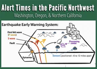
What would you do with seconds to prepare for earthquake shaking? With even a few seconds, the ShakeAlert® Earthquake Early Warning can save lives and reduce injuries by alerting people that an earthquake may cause shaking near you as it triggers automated actions.
On March 11, 2011, a devastating magnitude-9 earthquake struck off the coast of Tohoku, Japan, where the Pacific Plate dives beneath the Okhotsk Plate. On January 26th, 1700, the West Coast of the United States experienced a similar tsunami-generating megathrust earthquake. An earthquake like this will strike the Cascadia subduction zone again. How can we protect ourselves?
This new animation (2020) describes the ShakeAlert Earthquake Early Warning app: How it works, why we should have it. Made in collaboration with governmental agencies and universities on the West Coast.
We encourage the reuse and dissemination of the material on this site as long as attribution is retained. To this end the material on this site, unless otherwise noted, is offered under Creative Commons Attribution (CC BY 4.0) license


