In brief: Expect more sunshine today, but then a stalled boundary will bring a healthy chance of rain showers into the region on Thursday and possibly Friday morning. If you’re tired of the rain, the good news is that we’ll then dry out for awhile. But now that we’re approaching late May, sunny weather means highs in the 90s, of which there will be plenty next week.
Before getting to the forecast, Matt and I want to say a quick note of congratulations to chief meteorologist Frank Billingsley, who is retiring next month after 30 years at KPRC-TV. He has worked at Channel 2 for as long as I have lived and worked in the Houston area (1997), and we have covered many of the same extreme weather events, including Hurricanes Harvey, Rita, and Ike, Tropical Storm Allison, and the great freeze in 2021. Frank has always been friendly and helpful, and we wish him nothing but the best.
Wednesday
If you liked Tuesday, you’re in luck, because today will bring more sunshine and (somewhat) drier air. Highs will again flirt with 90 degrees. However, with winds swinging around to come from the southeast, we’ll see an influx of more moist air this evening, with lows only dropping into the lower 70s.

Thursday
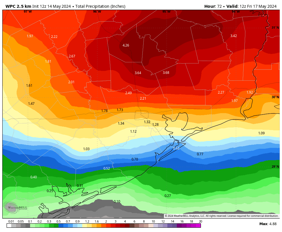
Did you miss the rain? Because it returns on Thursday and possibly Friday for a final engagement before exiting the area for awhile. I think we’ll see isolated to scattered showers on Thursday morning before more organized showers and thunderstorms arrive during the afternoon hours and persist into the evening or overnight hours. Once again, the most favored region for the heaviest rains will be north of Interstate 10, and likely in Montgomery County and points north. These inland areas should see 1 to 3 inches of rainfall, with higher bullseyes of 5 inches possible for some locations. Closer to the coast, south of Interstate 10, accumulations should be less. I’m most concerned about rivers, as flooding continues along the Trinity, East Fork of the San Jacinto, and lower Brazos basins.
Highs, otherwise, should be in the mid-80s with mostly cloudy skies. A fairly strong southeasterly breeze will be in place, with gusts up to 25 mph.
Friday
Another round of showers is possible on Friday morning before some probable clearing during the afternoon hours, with partly sunny skies. Highs will likely reach the mid- to upper-80s, depending on how much sun breaks through during the afternoon. Lows on Friday night will drop to around 70 degrees in Houston, give or take.
Saturday and Sunday
As high pressure takes hold, we have good confidence in an extended period of mostly sunny and warmer weather. Highs on Saturday are likely to reach about 90 degrees, with temperatures pushing into the lower 90s by Sunday. It will feel reasonably humid, with only a modest southerly wind.
Next week
Expect mostly sunny days for most of next week, with highs generally in the low-90s—although some inland locations could push into the mid-90s. Rain chances look low to non-existent at least through the middle of next week. For all intents and purposes, summer starts next week. Hope you’re ready!