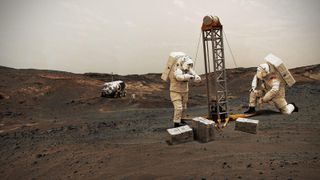
Humanity is getting a better idea of where to set up shop on Mars.
NASA plans to start launching crewed missions to Mars sometime in the 2030s, with the goal of setting up a research outpost on the Red Planet in the relatively near future. If such a base is to be sustainable over the long term, its occupants must live off the land, exploiting local resources to the extent possible, agency officials have said.
The most important of those resources is water ice, which can not only help keep Mars pioneers alive but also facilitate their trips back to Earth. (Water can be split into its constituent hydrogen and oxygen, the chief components of rocket fuel.) Setting up a base near accessible water also makes scientific sense, for it's possible that signs of Mars life, if it ever existed, could be found in or near such spots.
That base will likely be built in the Martian mid-latitudes, which feature plenty of water ice and enough warmth and sunlight to make operations feasible. The poles are very icy but also cold and dark; equatorial regions are warm and bright, by Martian standards, but also relatively dry. Mid-latitude terrain also tends to be at low elevations, making it easier for heavy human-class landers to touch down, NASA officials have said. (It's helpful to have more spacecraft-slowing atmosphere to plummet through, given that Mars' air is just 1% as thick as Earth's.)
Photos: The search for water on Mars
Book of Mars: <a href="https://www.awin1.com/awclick.php?awinmid=2961&awinaffid=103504&clickref=hawk-custom-tracking&p=https%3A%2F%2Fwww.magazinesdirect.com%2Faz-magazines%2F6942884%2Fbook-of-mars-2nd-edition.thtml" data-link-merchant="magazinesdirect.com"" target="_blank">$22.99 at Magazines Direct
Within 148 pages, explore the mysteries of Mars. With the latest generation of rovers, landers and orbiters heading to the Red Planet, we're discovering even more of this world's secrets than ever before. Find out about its landscape and formation, discover the truth about water on Mars and the search for life, and explore the possibility that the fourth rock from the sun may one day be our next home.
Hidden ice on Mars
Mars' mid-latitude ice is buried beneath the planet's famous red dirt. But NASA and its exploration partners are now getting a better idea of where the most accessible pockets of it are, thanks to a project called Subsurface Water Ice Mapping (SWIM), which is led by the Planetary Science Institute in Tucson, Arizona, and managed by NASA's Jet Propulsion Laboratory (JPL) in Southern California.
SWIM analyzes data gathered over the last two decades by three NASA orbiters — the Mars Reconnaissance Orbiter, Mars Odyssey and Mars Global Surveyor — using five different remote-sensing techniques, including neutron spectroscopy and radar. (Mars Global Surveyor's mission officially ended in 2007, but the other two orbiters are still going strong.)
Get the Space.com Newsletter
Breaking space news, the latest updates on rocket launches, skywatching events and more!

"Ultimately, NASA tasked the SWIM project with figuring out how close to the equator you can go to find subsurface ice," Sydney Do, the Mars Water Mapping Project lead at JPL, said in a NASA statement. "Imagine we’ve drawn a squiggly line across Mars representing that ice boundary. This data allows us to draw that line with a finer pen instead of a thick marker and to focus on parts of that line that are closest to the equator."
The SWIM team just released its first results, in a paper published online Monday (Feb. 8) in the journal Nature Astronomy. And those results are encouraging from a crewed exploration standpoint, revealing that large swaths of the mid-latitudes show evidence of ice buried at depths ranging from just an inch or two (a few centimeters) to 0.6 miles (1 kilometer).

A vital Martian resource
The new study does not flag specific sites for future crewed touchdowns, team members stressed. But it does serve as a resource for the people who will be making such decisions down the road, if all goes according to plan.
"Of course, safely delivering humans to Mars and ensuring their survival requires many other considerations beyond in situ utilization of water resources, including landing-site safety and solar and thermal specifications," study lead author Gareth Morgan, a senior scientist at the Planetary Science Institute, said in a separate statement.
"Defining such site requirements is beyond the scope of the SWIM project and would be premature, given that all human Mars mission plans are still in the conceptual stage," Morgan added. "We provide a hemispheric perspective of ice distribution to support initial landing-site studies and enable the community to explore the range of Martian terrains that host ice."
The ice picture could clear up considerably in the coming years, especially if a NASA orbiter called Mars Ice Mapper gets off the ground. NASA is discussing the Mars Ice Mapper concept with the space agencies of Japan, Canada and Italy, which may come onboard as partners. The mission could end up launching as early as 2026, agency officials have said.
And there's a lot of spacecraft action coming to the Red Planet very soon. Orbiters operated by the United Arab Emirates and China are scheduled to arrive at Mars on Tuesday (Feb. 9) and Wednesday (Feb. 10), respectively. And NASA's next Mars rover, Perseverance, will land on Feb. 18.
Mike Wall is the author of "Out There" (Grand Central Publishing, 2018; illustrated by Karl Tate), a book about the search for alien life. Follow him on Twitter @michaeldwall. Follow us on Twitter @Spacedotcom or Facebook.
Join our Space Forums to keep talking space on the latest missions, night sky and more! And if you have a news tip, correction or comment, let us know at: community@space.com.

Michael Wall is a Senior Space Writer with Space.com and joined the team in 2010. He primarily covers exoplanets, spaceflight and military space, but has been known to dabble in the space art beat. His book about the search for alien life, "Out There," was published on Nov. 13, 2018. Before becoming a science writer, Michael worked as a herpetologist and wildlife biologist. He has a Ph.D. in evolutionary biology from the University of Sydney, Australia, a bachelor's degree from the University of Arizona, and a graduate certificate in science writing from the University of California, Santa Cruz. To find out what his latest project is, you can follow Michael on Twitter.

