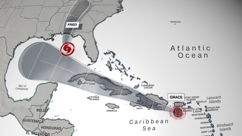


Tropical Storm Fred is anticipated to steadily strengthen as it tracks toward the Florida Panhandle on Sunday.
Meanwhile, a tropical depression, Grace, is tracking through the Caribbean toward Haiti, potentially affecting recovery efforts following a major 7.2-magnitude earthquake that struck Saturday.
On Sunday morning, Fred regained tropical storm status over the Gulf of Mexico, according to reports from an Air Force Reserve Hurricane Hunter aircraft. The storm had sustained winds of 45 mph and was 205 miles west-southwest of Tampa, Florida, Sunday evening.
A tropical storm warning has been issued for the coast of the Florida Panhandle from Navarre to the Wakulla-Jefferson county line ahead of Tropical Storm Fred. A tropical storm watch remains in effect for the coast of the Florida Panhandle from the Alabama-Florida border to Navarre along with inland areas of southern Alabama.
Tropical Storm Fred is forecast to gradually increase in strength as it tracks through the warm waters of the Gulf of Mexico on Sunday and Monday.
On the forecast track, the center of Fred should move across eastern and northern Gulf of Mexico through Monday, then make landfall in the Florida Panhandle, just west of Panama City, early evening Monday with winds of 60 mph.
The storm will bring gusty winds, bouts of heavy rain and isolated tornadoes to portions of the Keys and southern Florida Sunday.
A storm surge warning has also been issued for the coast of the Florida Panhandle from Indian Pass to Steinhatchee River. A storm surge warning means there is a danger of life-threatening inundation from rising water moving inland from the coastline during the next 36 hours.
The storm surge is forecast to be highest from Indian Pass to the Steinhatchee River in Florida where 3 to 5 feet is expected. A storm surge of 1 to 3 feet is forecast on Monday from the Alabama-Florida border to Indian Pass, including Pensacola Bay, Choctawhatchee Bay and Saint Andrew Bay.
Fred will also bring rain and gusty winds to other areas of the Southeast including Alabama, Georgia, and the Carolinas into the early portion of the upcoming week.
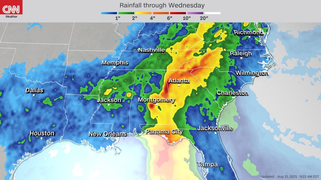
The rainfall across the Southeast will be enhanced as Fred interacts with a frontal system. Widespread rainfall totals of 3-6 inches are forecast across the Southeast, with isolated totals up to 9 inches possible through Tuesday.
Fred on Sunday prompted the closure of schools throughout the Florida Panhandle. Schools in Bay County, Okaloosa County, Walton County and Santa Rosa County announced that all classes were canceled Monday, as were after school activities.
Classes are expected to resume on Tuesday, according to posts on each school district’s website.
Tropical Depression Grace to hit Haiti
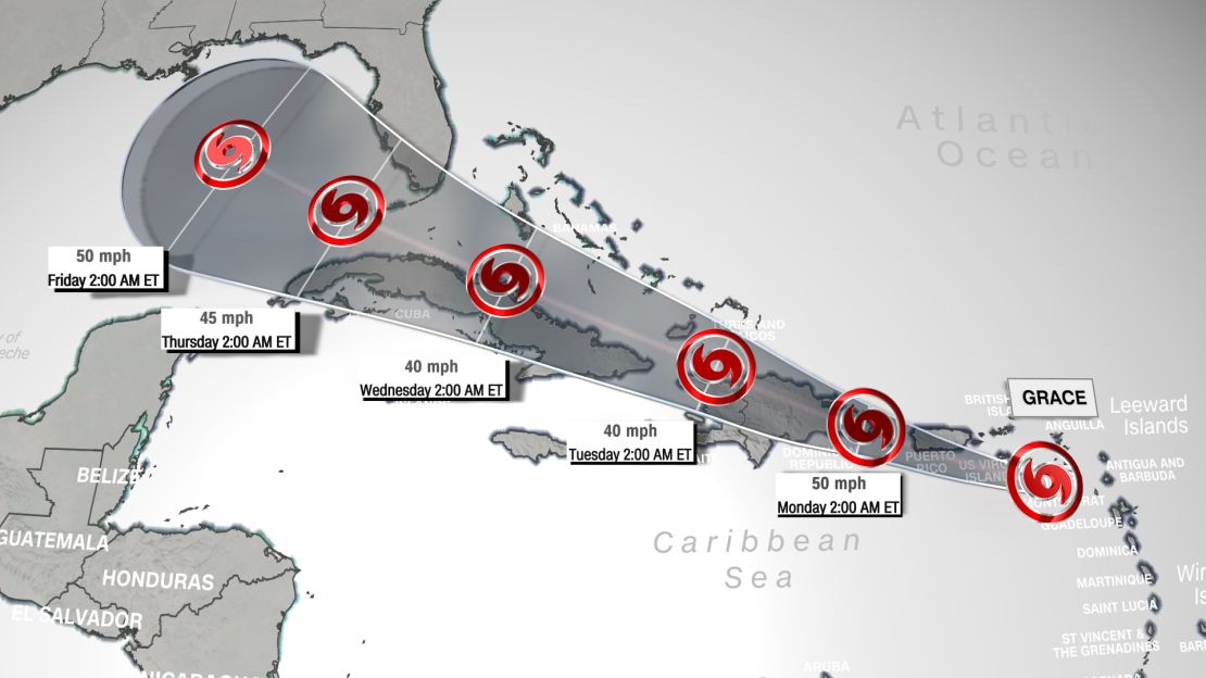
Grace weakened from a storm to a tropical depression Sunday, with maximum sustained winds of 35 mph.
A tropical storm watch is in effect for the entire coast of Haiti in advance of Grace, which was located 155 miles southeast of Santo Domingo, Dominican Republic, Sunday evening.
The current forecast from the National Hurricane Center has Grace traveling through the Greater Antilles, affecting the Dominican Republic and Haiti on Monday and Tuesday, with expected wind speeds at 40-50 mph.
The center of the storm may pass just north of where the earthquake struck Haiti, but there will still be impacts that can hamper aid and rescue efforts. Gusty winds and heavy rain are the main threats associated with this storm for Haiti.
A tropical storm warning for Grace for Puerto Rico, and the Virgin Islands and parts of the Dominican Republic has been discontinued the National Hurricane Center said in its latest advisory, and the warning for the Dominican Republic was changed to a watch by the country’s government, the NHC said.
A tropical storm watch means storm conditions with winds from 39-74 mph are possible within 48 hours of being issued, and a warning means such conditions for affected areas are expected.
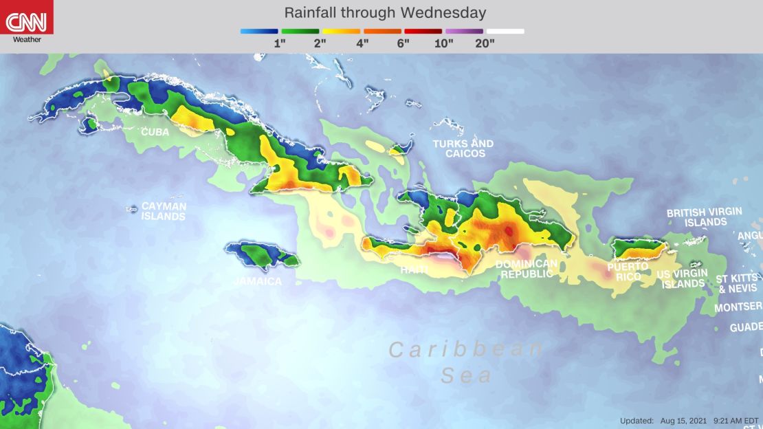
Grace is forecast to bring 3-6 inches of rain to Puerto Rico and portions of the Leeward Islands. Isolated totals of up to 8 inches are possible across Puerto Rico, which could lead to flash flooding and mudslides.
For Haiti and the Dominican Republic, widespread rainfall of 4-7 inches is forecast, with isolated amounts of up to 15 inches that could also lead to flash flooding and mudslides on Monday and Tuesday.
The intensity and the track of Grace after passing Hispaniola remains uncertain at this time. The NHC track currently has the storm tracking south of Florida and into the Gulf of Mexico by the end of the week.
CNN’s Tyler Mauldin, Jackson Dill and Gene Norman contributed to this report.