AccuWeather


- Tornado Warning
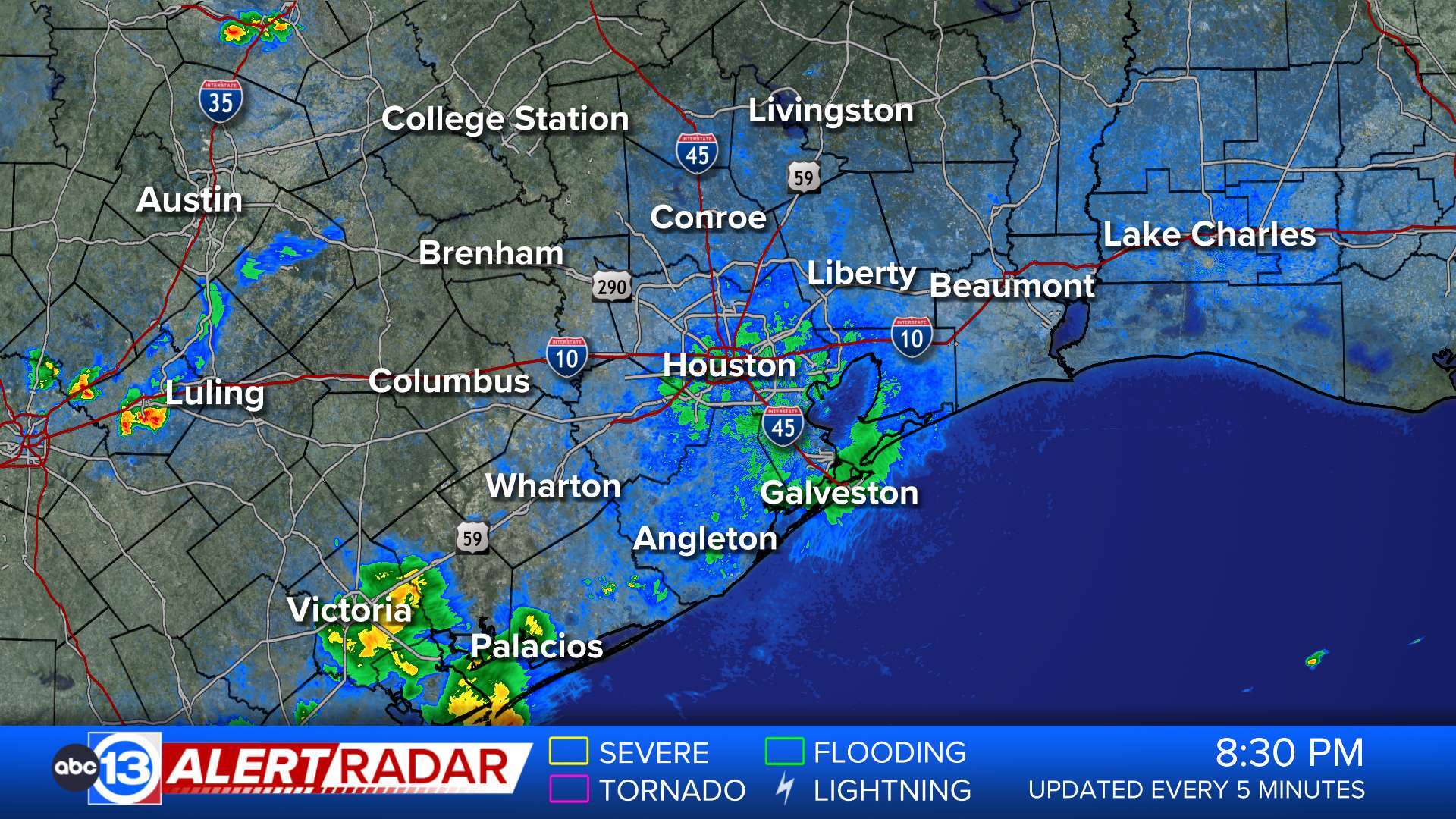
TORHGX The National Weather Service in League City has issued a * Tornado Warning for... East central Waller County in southeastern Texas... Northwestern Harris County in southeastern Texas... * Until 630 PM CDT. * At 555 PM CDT, a severe thunderstorm capable of producing a tornado was located near Hockley, or 10 miles southeast of Prairie View, moving east at 40 mph. HAZARD...Tornado. SOURCE...Radar indicated rotation. IMPACT...Flying debris will be dangerous to those caught without shelter. Mobile homes will be damaged or destroyed. Damage to roofs, windows, and vehicles will occur. Tree damage is likely. * This dangerous storm will be near... Cypress around 600 PM CDT. Jersey Village and Addicks Park Ten around 610 PM CDT. Spring Branch West, northern Eldridge / West Oaks, and Willowbrook around 615 PM CDT. Other locations impacted by this tornadic thunderstorm include Addicks and Memorial.More
- Severe Thunderstorm Warning
SVRHGX The National Weather Service in League City has issued a * Severe Thunderstorm Warning for... Southeastern Austin County in southeastern Texas... Northwestern Fort Bend County in southeastern Texas... Southwestern Montgomery County in southeastern Texas... Southeastern Waller County in southeastern Texas... Northwestern Harris County in southeastern Texas... * Until 615 PM CDT. * At 548 PM CDT, severe thunderstorms were located along a line extending from near Todd Mission to near Pattison to near Sealy, moving east at 70 mph. HAZARD...70 mph wind gusts. SOURCE...Radar indicated. IMPACT...Expect considerable tree damage. Damage is likely to mobile homes, roofs, and outbuildings. * Locations impacted include... Sugar Land, Katy, Richmond, Tomball, Jersey Village, Pinehurst, Town West, Pecan Grove, Eldridge / West Oaks, Spring Branch West, Addicks Park Ten, Mission Bend, Spring Branch North, Wallis, Fulshear, Simonton, Stagecoach, Cinco Ranch, Weston Lakes, and Four Corners.More
- Flash Flood Warning
FFWHGX The National Weather Service in League City has extended the * Flash Flood Warning for... Central Brazos County in southeastern Texas... West Central Grimes County in southeastern Texas... * Until 715 PM CDT. * At 514 PM CDT, Doppler radar indicated thunderstorms producing heavy rain across the warned area. Between 2 and 3 inches of rain have fallen. Additional rainfall amounts of 2 to 3 inches are possible in the warned area. Flash flooding is ongoing or expected to begin shortly. HAZARD...Life threatening flash flooding. Thunderstorms producing flash flooding. SOURCE...Radar. IMPACT...Life threatening flash flooding of creeks and streams, urban areas, highways, streets and underpasses. * Some locations that will experience flash flooding include... College Station, Bryan, Kyle Field and Wellborn.More
- Flood Watch
* WHAT...Flooding caused by excessive rainfall continues to be possible. * WHERE...A portion of southeast Texas, including the following areas, Austin, Brazos, Burleson, Coastal Harris, Grimes, Houston, Inland Harris, Madison, Montgomery, Northern Liberty, Polk, San Jacinto, Southern Liberty, Trinity, Walker, Waller and Washington. * WHEN...Through Friday morning. * IMPACTS...Excessive runoff may result in flooding of rivers, creeks, streams, and other low-lying and flood-prone locations. * ADDITIONAL DETAILS... - Widespread thunderstorms will develop across the area this afternoon and evening, with the presence of a warm frontal boundary and abundant moisture providing favorable conditions for heavy rainfall. The flood threat will be further exacerbated by well-saturated soils still present across portions of the region due to significant antecedent rainfall. In general, 3-6" of new rainfall can be expected for areas north of the I-10 corridor through this evening. Isolated locally higher totals are possible as well. This may result in street flooding, as well as rises along area rivers and creeks. - http://www.weather.gov/safety/floodMore
- Flood Warning
...Forecast flooding changed from Minor to Moderate severity and increased in duration for the following rivers in Texas... East Fork San Jacinto near New Caney affecting Harris, Montgomery and Liberty Counties. For the East Fork San Jacinto River...including New Caney...Moderate flooding is forecast. * WHAT...Minor flooding is occurring and moderate flooding is forecast. * WHERE...East Fork San Jacinto near New Caney. * WHEN...Until further notice. * IMPACTS...At 58.0 feet, Minor lowland flooding begins in the vicinity of the gage with minor roads such as Chinquapin and Riverside Roads beginning to flood. At 62.0 feet, Moderate lowland flooding begins with secondary roads near the river inundated, including FM 1485 west of the river. * ADDITIONAL DETAILS... - At 10:00 AM CDT Thursday the stage was 59.1 feet. - Bankfull stage is 54.5 feet. - Recent Activity...The maximum river stage in the 24 hours ending at 10:00 AM CDT Thursday was 61.5 feet. - Forecast...The river is expected to rise above flood stage tomorrow afternoon and continue rising to a crest of 65.2 feet Sunday afternoon. - Flood stage is 58.0 feet. - Flood History...This crest compares to a previous crest of 64.8 feet on 10/21/1998. - http://www.weather.gov/safety/floodMore
- Flood Warning
...The Flood Warning continues for the following rivers in Texas... Brazos River near Rosharon affecting Brazoria and Fort Bend Counties. For the Brazos River...including Rosharon...Minor flooding is forecast. * WHAT...Minor flooding is occurring and minor flooding is forecast. * WHERE...Brazos River near Rosharon. * WHEN...Until further notice. * IMPACTS...At 43.0 feet, Minor lowland flooding begins in vicinity of gage as flow escapes the main channel. Cattle should be removed from low areas in the flood plain. * ADDITIONAL DETAILS... - At 10:00 AM CDT Thursday the stage was 44.2 feet. - Bankfull stage is 40.0 feet. - Recent Activity...The maximum river stage in the 24 hours ending at 10:00 AM CDT Thursday was 45.7 feet. - Forecast...The river is expected to fall to 45.7 feet Tuesday morning. - Flood stage is 43.0 feet. - Flood History...This crest compares to a previous crest of 45.5 feet on 05/19/2004. - http://www.weather.gov/safety/floodMore
- Flood Warning
...The Flood Warning continues for the following rivers in Texas... Trinity River near Moss Bluff affecting Chambers and Liberty Counties. For the Trinity River...including Crockett, Riverside, Romayor, Goodrich, Liberty, Moss Bluff...Major flooding is forecast. * WHAT...Moderate flooding is occurring and moderate flooding is forecast. * WHERE...Trinity River near Moss Bluff. * WHEN...Until further notice. * IMPACTS...At 15.2 feet, Moderate lowland flooding begins in the vicinity of the gage. * ADDITIONAL DETAILS... - At 9:30 AM CDT Thursday the stage was 15.4 feet. - Bankfull stage is 9.2 feet. - Recent Activity...The maximum river stage in the 24 hours ending at 9:30 AM CDT Thursday was 15.6 feet. - Forecast...The river is expected to fall to 15.4 feet Tuesday morning. - Flood stage is 12.2 feet. - Flood History...This crest compares to a previous crest of 15.2 feet on 06/03/2016. - http://www.weather.gov/safety/floodMore
- Flood Warning
...The Flood Warning continues for the following rivers in Texas... Trinity River at Liberty affecting Liberty County. For the Trinity River...including Crockett, Riverside, Romayor, Goodrich, Liberty, Moss Bluff...Major flooding is forecast. * WHAT...Major flooding is occurring and major flooding is forecast. * WHERE...Trinity River at Liberty. * WHEN...Until further notice. * IMPACTS...At 29.0 feet, Major lowland flooding begins as homes in several subdivisions above Liberty begin flooding. Extensive flooding over much of Liberty County can be expected with each incremental rise in the river. * ADDITIONAL DETAILS... - At 9:15 AM CDT Thursday the stage was 30.0 feet. - Bankfull stage is 21.0 feet. - Recent Activity...The maximum river stage in the 24 hours ending at 9:15 AM CDT Thursday was 30.1 feet. - Forecast...The river is expected to rise to a crest of 30.0 feet this afternoon. It will then rise to 31.4 feet Tuesday morning. Additional rises are possible thereafter. - Flood stage is 26.0 feet. - Flood History...This crest compares to a previous crest of 31.0 feet on 10/21/1994. - http://www.weather.gov/safety/floodMore
- Flood Warning
...Forecast flooding changed from Minor to Major severity for the following rivers in Texas... Trinity River near Goodrich affecting San Jacinto, Polk and Liberty Counties. For the Trinity River...including Crockett, Riverside, Romayor, Goodrich, Liberty, Moss Bluff...Major flooding is forecast. * WHAT...Minor flooding is occurring and major flooding is forecast. * WHERE...Trinity River near Goodrich. * WHEN...Until further notice. * IMPACTS...At 38.0 feet, Moderate lowland flooding begins. At 41.0 feet, Major lowland flooding begins as the slab elevation of homes on the right bank just below Lake Livingston is reached. * ADDITIONAL DETAILS... - At 9:45 AM CDT Thursday the stage was 36.4 feet. - Bankfull stage is 33.0 feet. - Recent Activity...The maximum river stage in the 24 hours ending at 9:45 AM CDT Thursday was 36.8 feet. - Forecast...The river is expected to rise to a crest of 43.8 feet Saturday morning. - Flood stage is 36.0 feet. - Flood History...This crest compares to a previous crest of 43.7 feet on 11/15/1998. - http://www.weather.gov/safety/floodMore