1. Introduction
The city of Aksu is a river oasis on the northern edge of the Taklimakan Desert, Xinjiang Uyghur Autonomous Region, Northwest China. It is located in an arid surrounding, feeding only on the water of Aksu River, a tributary of the Tarim River. Aksu City is suffering from regular severe dust storms. In 1986 the prefectural authorities of Aksu began to lay out an irrigated peri-urban plantation called Kökyar Protection Forest, aiming at reducing the impact of desert dust on the city [
1,
2]. This instance can be described as an act of ecological engineering which attempts to improve human wellbeing by generating ecosystem services at the place where they are needed.
In China as well as abroad, the Kökyar Protection Forest is far-famed and commonly regarded as a paragon of successful afforestation under difficult conditions, by this role model function encouraging other areas to adopt idea and design [
2] (also cf. Interview Ibrahim Yusup). Prevalent sources describe it as an afforestation project with manifold positive environmental, social, and economic effects [
1,
2,
3,
4]. However, these claims are lacking a systemic view of the bigger picture. While over the last decades huge afforestation efforts have taken place in China’s drylands XX, in many cases these efforts have not been beneficial because the installed trees or shrubs have a higher water consumption than the natural vegetation cover, thus overexploiting the water balance and leading to the dieback of these forests [
5,
6,
7,
8]. In the case of the Kökyar Protection Forest, permanent sufficient water supply is guaranteed locally by irrigation, yet the negative trade-off effects of its excessive irrigation water consumption are transferred on downstream ecosystems along the middle and lower reaches of the Tarim River which consequently suffer from water shortages.
The incorporation of ecosystem services into policies and planning in different sectors and levels of governance remains a challenge for water and natural resources management not only in China. A first step in this effort is to assess the services in an appropriate way [
9]. The second challenge is to incorporate the ecosystems considerations into planning practice by e.g., modelling and using scenarios [
10] and by bringing relevant stakeholders together through participatory dialogues [
11]. The broader perspective of upstream-downstream effects and water allocation in the Tarim basin has been described in detail by [
12]. Effects of corrective measures (water diversion) which aim at alternative water sources for the lower ends of Tarim have been assessed by [
13] and reveal the limits of human interventions when (water) ecosystems are severely altered. It is often the broader picture on watershed level, which is missing. Incremental decisions without a comprehensive sustainability assessment tend to blind for effects on complex systems [
14].
This paper intends to analyse the Kökyar Protection Forest from a holistic perspective that integrates the hidden downsides and externalities of the project. The extent of ecological damages at the middle and lower reaches of Tarim River will be estimated, and its alleged positive environmental, social and economic effects will be challenged by a more comprehensive sustainability analysis. In this respect, the following two research questions are formulated:
First research question: Is the Kökyar Protection Forest sustainable in the three dimensions of (a) environmental sustainability, (b) social sustainability and (c) economic sustainability?
Second research question: Is the Kökyar Protection Forest an afforestation project or an agricultural land reclamation project?
1.1. Case Study Area
1.1.1. The Tarim Basin
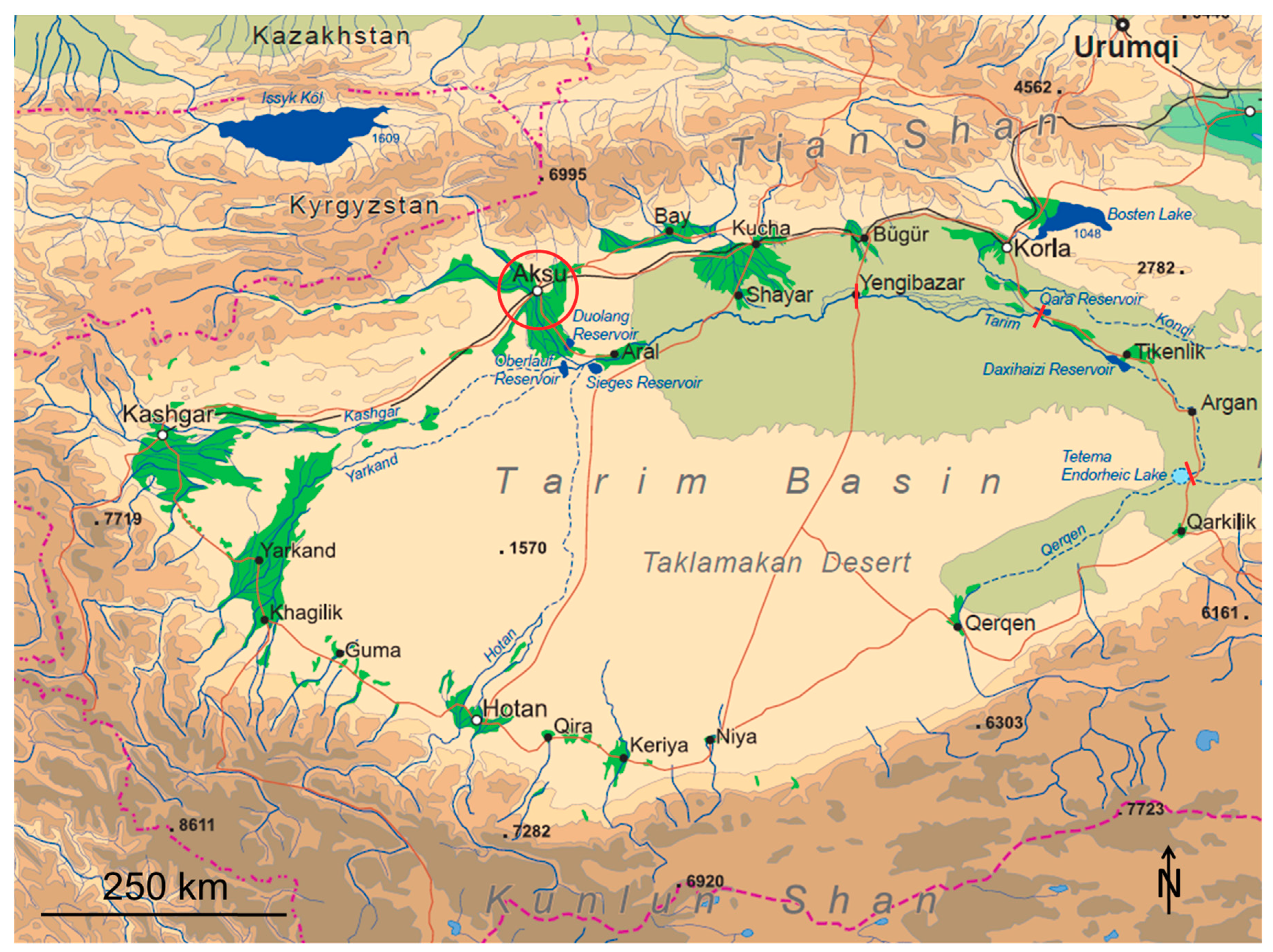
The Tarim Basin, situated in the west of the Xinjiang Uyghur Autonomous Region in Northwest China, is formed by the Taklimakan Desert, surrounded by the big mountain ranges of Tian Shan, Kunlun Shan and Karakorum from north, south and west. Its continental location, precipitation shadow from the surrounding mountain ranges, and high solar radiation result in a hyper-arid climate. Under these conditions with an annual potential evaporation of 1000 mm to 2000 mm and with an annual precipitation of less than 100 mm, the life of natural ecosystems as well as of human settlements depends to a high degree on river water [
15,
16,
17,
18]. Rivers are forming all along the fringes of the Taklimakan Desert wherever there is enough accumulation of melting water from glaciers and snow, and of precipitation in the adjacent mountain ranges. They usually sustain smaller or bigger oasis cities with surrounding irrigated agricultural systems, and finally dry up in the desert (cf.
Figure 1).
The longest river, the Tarim River, forms at Aral as a junction of Yarkant River, Hotan River, and Aksu River. It then flows over 1000 km eastward to the reservoir Daxihaizi where it ends in the desert [
21] (cf.
Figure 1). Due to a low gradient and high sediment loads, it meanders heavily, frequently changes its course, and splits up into a huge inland delta. Bordered by the slopes of Tian Shan in the north and the Taklimakan Desert in the south, its mobile flood plain forms a green corridor of about 600 km length and potentially up to 100 km width [
17].
The natural riparian vegetation along the Tarim River, the so-called Tugai vegetation, synonymously also called Tugai forests [
20], consists of different plant community types which spatially merge into each other according to water availability: Areas closest to the river or to recently flooded depressions contain mainly reed stands (
Phragmites australis and
Calamagrostis pseudophragmites) and young bushy Euphrates poplar stands (
Populus euphratica). Areas with medium water availability are covered with thick Tugai forests, composed of mainly Euphrates poplar, desert poplar (
Populus pruinosa) and oleasters (
Elaeagnus spp.), associated with shrubs and herbaceous species, such as tamarisks (
Tamarix spp.) and common reed (
Phragmites australis). In the drier areas, there are Tugai bushes, consistent of tamarisks and Euphrates poplars, mostly with sparse or no undergrowth. The adjoining semi-desert shows mostly tamarisk stands with some rare Euphrates poplar stands, the vegetation cover getting thinner and thinner [
17,
22,
23,
24,
25]. Locally, the Tugai vegetation along the Tarim River used to provide vital ecosystem services to Uyghur communities of fishers, hunters, herdsmen and farmers on which their culture is fully dependent [
26]. On a supra-regional scale, it serves as a barrier against wind and sand erosion that regulates dust storms and prevents the desert from spreading northwards [
17], where important settlements lie, such as the cities of Shayar, Yengibazar, Kucha, Bügür, and Korla, many smaller villages, and the connecting infrastructure. Globally, it serves an important role in biodiversity conservation, since the Tarim Basin represents one of the last refuge areas of Euphrates poplar stands, harbouring more than half (352,200 ha) of the worldwide remaining area of this rare type of floodplain forest [
17,
27]. In the hyper-arid local climate, Tugai forests provide habitats for a great number of animal and plant species, many of which are endangered, thus constituting important biodiversity hot-spots [
22,
28].
In the second half of the 20th century, large-scale land reclamation, especially for cotton production by the Xinjiang Production and Construction Corps, combined with the associated hydraulic engineering to secure the ever-growing need for irrigation water all along the Tarim River and its tributaries, have led to a dramatic shrinking of these forests, making the Tarim floodplain Xinjiang’s most seriously affected area of desertification [
17,
29,
30], jeopardising their original ecosystem services, and pushing traditional use forms towards extinction [
26]. The area of irrigated land has increased all over the Tarim Basin, from 706,000 ha in 1949, over 1,330,000 ha in 1980 and 1,412,000 ha in 1990 [
31], to 1,600,000 ha in 2010 [
32].
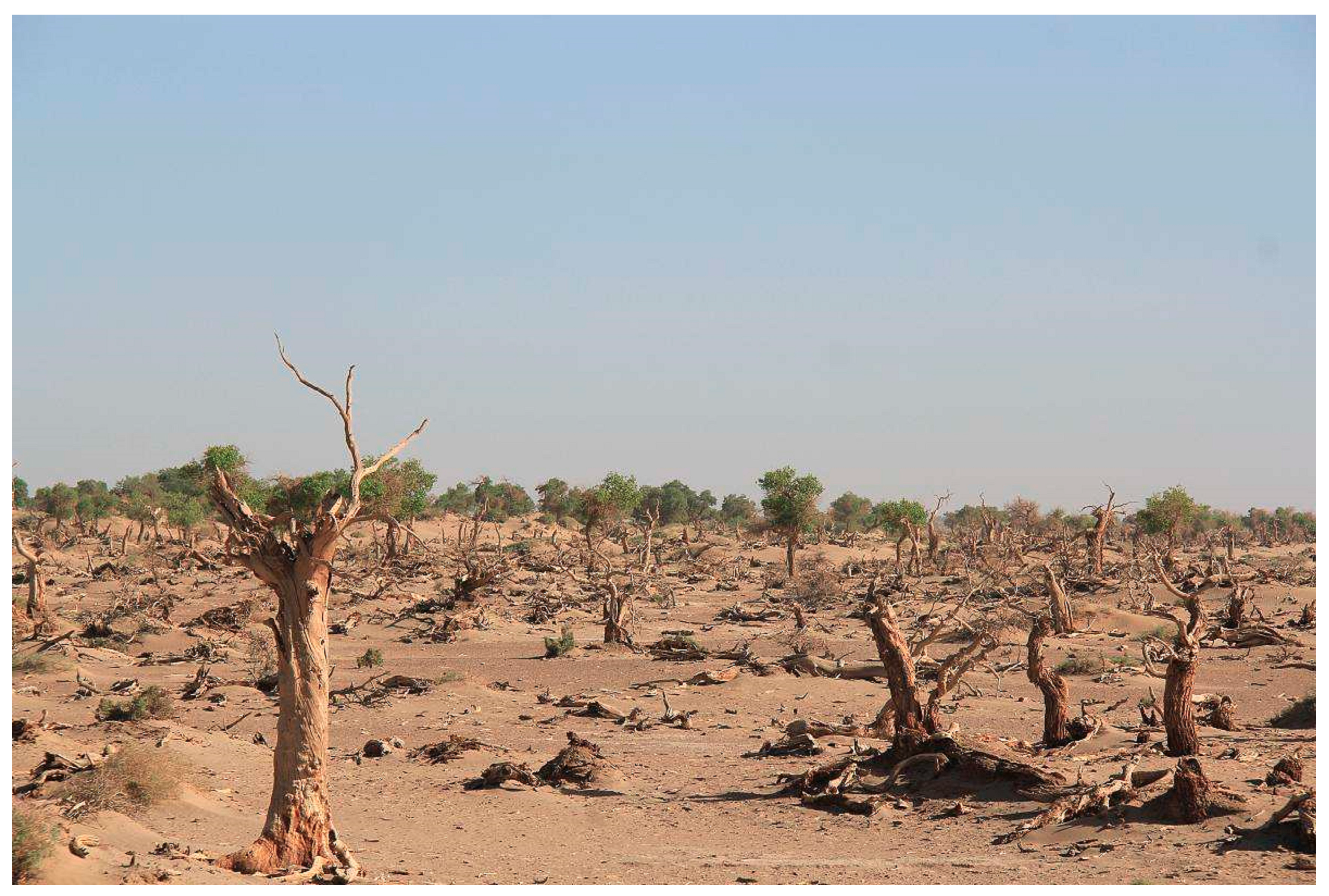
Before 1972, the river did not end at Daxihaizi but reached 320 km further down to the former terminal Detama Lake. This whole section dried up gradually after 1972 due to upstream water extraction [
17,
21]. Consequently, the vegetation died or deteriorated [
33]. Back in 1958, 54,000 ha of Euphrates poplar forests had been recorded in the lower reaches of Tarim River, of which merely 6700 ha (12%) had survived in the 1990s [
17]. Autochthonous Uyghur villages had to be resettled [
26]. The strategic National Highway 218 that follows the course of the Tarim River’s former lower reaches between Tikanlik and the former terminal Detama Lake is threatened by shifting sand dunes [
33].
Chinese authorities, instead of limiting the ongoing extension of irrigation agriculture, have been responding to these water shortages by a number of additional hydraulic engineering projects of which only two shall be named here: Water from the Bosten Lake is diverted to the lower reaches by new canal systems and pumping stations, in order to revitalise the dying Tugai forests in the lower reaches and to protect the strategic road [
34]. The upper and middle reaches of the Tarim River are controlled in their flow by protection measures along its river bed, and by installation of dikes in a total length of 1340 km [
34,
35]. This is intended to speed up its flow and bring more water to the dying lower reaches, while simultaneously ensuring water extraction for agriculture at the river side. Yet, preventing the Tarim River from meandering and inhibiting natural flooding will leave the Tugai forests in the adjacent floodplain to desiccation, thus further accelerating the ecological degradation [
22] (cf.
Figure 2).
Due to the fact of Tarim River being an inland river, the classical upstream-downstream conflict that also can be observed in other river basins in Central Asia [
16,
37,
38,
39], is especially pronounced in the case of the Tarim River—every drop of water consumed in the upper reaches is directly missing in the lower reaches.
1.1.2. Aksu City and the Kökyar Protection Forest
(The description of the situation in Aksu has been published partially in similar wordings in [
40].)
One of the upstream water consumers is the oasis city of Aksu, lying at the Aksu River, with an annual discharge of 3 billion m
3 of water or 77% of Tarim River’s overall water yield being its main tributary [
41]. The geographical position of Aksu City is close to Kyrgyzstan, on a long slope between the border mountain range of the Tian Shan in the north and the Taklimakan Desert in the south, at 41°10’ N and 80°15’ E, and at an altitude of 1100 m a.s.l. (above sea level). Its population reached 580,000 in the year 2012 [
42]. Due to its location on the Aksu River, Aksu is water-rich, which allowed for the development of irrigation agriculture, forming a huge river oasis in the west, east and south of Aksu City (ca. 1000 km², including Awat and Onsu County) [
43]. However, the surrounding deserts become very present, whenever the regular hot and dry north winds blow down from the Tian Shan, raising dust and sand from the barren areas north of the oasis and covering Aksu City in dust and sand storms (annual average of 11.5 sand storm days with visibility less than 1 km) [
2].
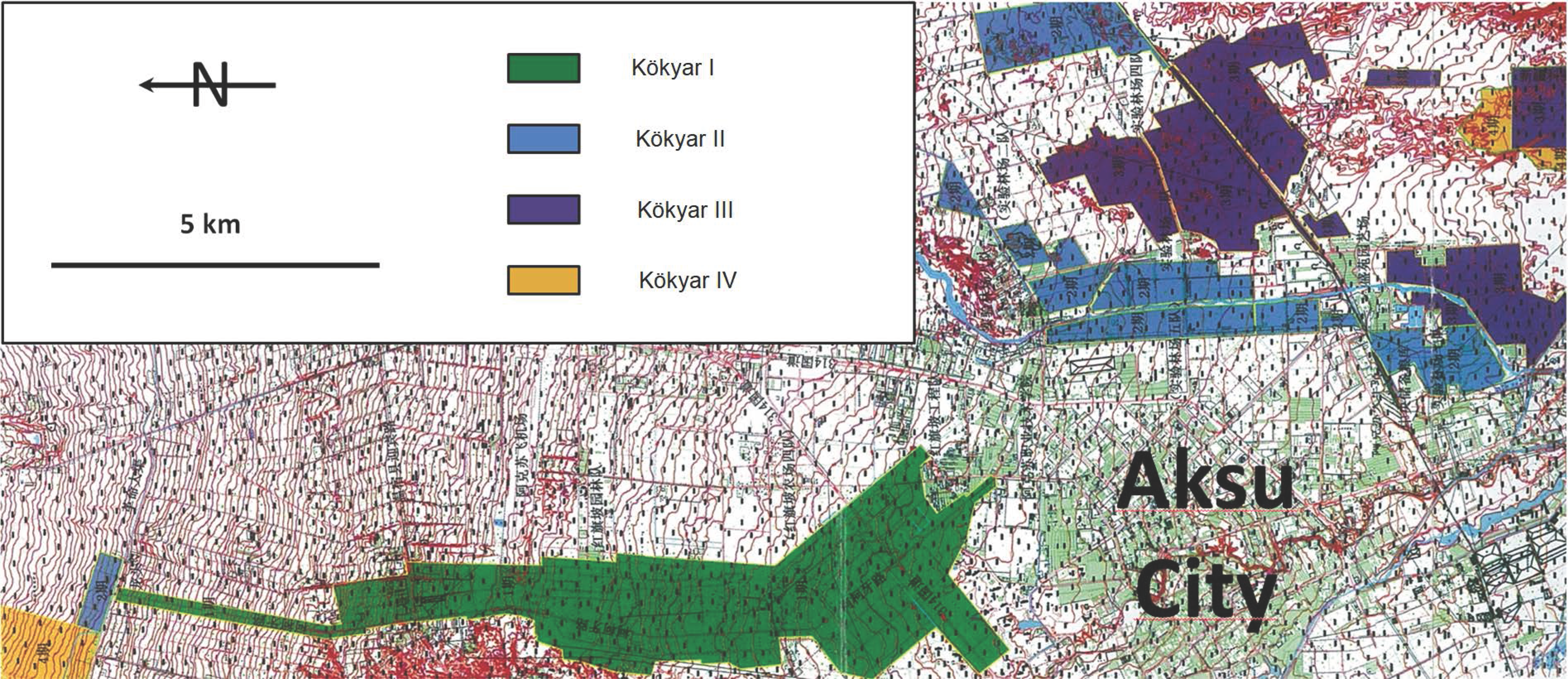
As a response to the dust problems, in the 1980s the local authorities decided to lay out a peri-urban shelterbelt plantation, called Kökyar Protection Forest. Work began in 1986 and was completed in 1990, the plantation then covering an area of 1308 ha [
2]. From 1990 onward, the project was extended by three more project periods, each of which converted more patches of desert land into forest plantations (cf.
Figure 3). The four project periods and their corresponding areas were then chronologically labelled Kökyar I to IV, while the complete title, Kökyar Protection Forest, usually refers to all four project areas together. According to local authorities, the total area of Kökyar I, II, and III covered 3842 ha by 2005 [
1,
3], while numbers for Kökyar IV are yet to be published. Due to the missing data for Kökyar IV, this paper will focus on the Kökyar Protection Forest only in the extent of Kökyar I, II, and III.
The Kökyar Protection Forest is designed as a raster of shelterbelt strips in which rectangular orchard plots are embedded. The shelterbelt strips consist mainly of white poplar (
Populus alba var. ‘Pyramidalis’), while the orchard plots are mainly planted with apple and pear. Jujube, walnut, and grapes and others play a minor role (Kökyar socio-economic household survey). The share of the shelterbelt strips in the plantation has dropped from 52% in Kökyar I to 42% in Kökyar II and to only 10% in Kökyar III, in favour of increasing orchard shares (comp.
Table 1). Context, history, site conditions, and socio-economic functioning of the Kökyar Protection Forest have been widely described by [
40].
The Kökyar Protection Forest is not unique but rather forms part of a series of such greening projects in different cities of the Tarim Basin, e.g., in Korla, Kashgar and Hotan [
43]. However, among them all, Kökyar is regarded as a kind of lighthouse project due to its vast dimensions and because it was realised under difficult conditions without the aid of the central government. An accompanying publicity effort, including the publication of books and documentaries as well as the erection of a large exhibition hall, further boosted its prominence [
1,
2,
3,
4]. In 1996, it was included in the “Global 500 Role of Honour for Environmental Achievement” of the United Nations Environmental Programme [
2,
3]. It is claimed as an afforestation project for combatting desertification, with multiple positive environmental, social, and economic effects (cf.
Figure 4). Environmentally, it is regarded as a means for achieving an ecological equilibrium, with the effects of dust and sand fixation, air purification, air humidification, etc. Socially, it is regarded as a guarantor for social sustainable development, with the effects of improvement of living conditions in Aksu, employment, patriotic and environmental education, increase of social coherence between cadres and the people, military and civilians, and between all ethnicities, etc. Economically, it is regarded as guarantor for sustainable economic development, with the effects of generation of rural incomes, and strengthening of the local economy [
1,
2,
3,
4]. Most of these claimed positive effects are attributable to the provisioning, regulating, and cultural ecosystem services of forests.
Yet, the Kökyar Protection Forest is an artificial forest plantation that depends fully on regular irrigation fed by river water. Since its irrigation water is diverted from the Tarim River’s main tributary Aksu River, every drop of water spent on the upstream Kökyar Protection Forest is directly missing in the downstream areas. By this, it contributes to the ongoing degradation and desiccation of the natural Tugai forests in the middle and lower reaches of the Tarim River, consequently reducing ecosystem services there. This makes clear that the ecosystem services at Aksu are not created out of thin air, but rather translocated from downstream.
2. Materials and Methods
Methods that were used to assess the Kökyar Protection Forest included a water use calculation, a literature review, a household survey, semi-structured interviews, field trips and stakeholder dialogues with relevant actors.
The water use calculation is the core argument of the paper. By comparing the water consumption of the Kökyar Protection Forest at Aksu with the water consumption of the natural Tugai forests at the middle and lower reaches of the Tarim River, it reveals the area of Tugai forests that are sacrificed for the Kökyar plantation. It was executed as an evapotranspiration calculation using the Penman-Monteith equation [
44,
45], which can provide a good estimation of long-term evapotranspiration but should not be understood as an exact assessment of actual evapotranspiration. Starting out from the evapotranspirated water amount is the most precise, since only that amount of water which is actually absorbed and consumed by plants and upper soil layers is accounted for, while the irrigation water approach would also falsely account for those amounts of water that trickle into deeper aquifers and are finally discharged back into the river. The Penman-Monteith calculation is based on 4 basic climate parameters and 1 vegetation-specific parameter which jointly control evapotranspiration. These are: solar radiance, temperature, relative humidity and wind speed, and the so-called crop coefficient.
The necessary climate data were taken from different sources. (Climate data of Kökyar: annual average sunshine duration from [
1]; monthly average temperature [
1], averaged between Aksu City and Onsu County Town; relative humidity from [
1], averaged between Aksu City and Onsu County Town; monthly average wind speed from [
2], averages of the years from 1987 to 1990. Climate data of the Tarim River’s middle and lower reaches, at Tikanlik: annual average sunshine duration taken from [
46]; monthly average temperature from [
47], averages of the years 1961 to 1990; monthly average relative humidity and monthly average wind speed from [
48], averages of the last 20 years.)
Crop coefficient data were adapted from three sources. (Orchards: adapted from [
45], data for: deciduous orchard, high latitudes, apples, no ground cover, killing frost. White poplar: adapted from [
49]. Euphrates poplar: adapted from [
50].) Crop coefficients for the frost months have been reduced from the 0.2 proposed as general values by [
45] down to 0.1, taking the extremely arid conditions of the specific locality into account. Penman-Monteith evapotranspiration calculations have to be treated carefully under conditions of dry climates, since the crop coefficients can result in overestimations of the real evapotranspiration in those cases where dry periods leave no water to be evaporated in the upper soil layers. In the case of this paper, however, the crop coefficients are applicable, because the Kökyar orchards are irrigated regularly and to a degree that guarantees maximal harvests, which implies that there is sufficient water in the upper soil layers all over the growing period; and the crop coefficient data for white poplar and Euphrates poplar were generated under water regimes similar to those in the present research area—by virtue of this fact, the coefficients already reflect the low water availability in upper soil layers.
As part of an ex-post analysis of the greening project we analysed the two volumes of the Kökyar annals [
1,
2] and other public documents that were openly available. Scientific literature on the Tarim Basin and the Kökyar plantation area in particular included articles both in Chinese and in international journals and books.
A household survey among small-scale tenant farmers aimed at assessing the viability of the greening project in economic terms. Socio-economic data (income from farming, annual costs, willingness to continue farming in coming years, etc.) was collected from 19 households living in the Kökyar I area. A more detailed description of the questions and results of this survey have been published in [
40].
Semi-structured interviews were conducted during field trips to the Tarim Basin and the Kökyar Protection Forest in particular. Interview partners included cotton farmers, representatives of the Aksu environmental administration, Kökyar Forest Bureau, as well as farmers and companies that are active in the Kökyar greening project. These interviews were documented and analysed for the key insights.
A series of stakeholder workshops and World Café-type sessions gave an opportunity to have a dialogue and reflection of different viewpoints among representatives of actors. Participants included the founder of the Kökyar greening project, representatives of the local municipal administration, youth movement and academics. A documentation of these dialogues, which were conducted mostly with upstream actors, can be found in [
51].
The multiple methods that were used for the paper helped us in gaining a comprehensive and systemic picture of the Kökyar Protection Forest and its relation to the river basin. Close interaction with relevant actors was an essential part of our transdisciplinary research approach [
52].
In the following we assess the sustainability of the greening project by looking at it through three lenses: the environmental, the social and the economic lenses. The division of sustainability into the three dimensions of economic, social and environmental sustainability goes back to the Brundtland report. Subsequent research has fostered the view of the three dimensions being nested within each other, i.e., the economy being a subsystem within society which, in turn, is a subsystem within the environment [
53]. This perception implies that the inner subsystems cannot exist sustainably without the corresponding outer systems, i.e., there cannot be a sustainable economy without a sustainable society, and there cannot be a sustainable society without a sustainable environment. Consequently, effects within the different dimensions cannot be simply offset against each other,
e.g., damages to the environment cannot be offset by economic benefits. Furthermore, ecosystem functioning is generally characterised by “extensive uncertainty, by irreversibility and by non-linearities that genenerate potentially large negative effects from ecosystem loss or degradation” [
54]. These risk factors appear especially pronounced in cases of fragile environments, such as the drylands in question, and in cases of already endangered ecosystem types and species, such as the Tugai vegetation. Under such conditions of unknown risks, the potential costs are presently not fathomable. Out of these reasons, we have to refrain from monetizing social and environmental costs and benefits and charge them up against each other and against the economic effects, as would be done in standard cost-benefit analysis. Instead, we will describe social and environmental effects qualitatively and treat all three dimensions separately, in order to avoid comparing incommensurable items. While this qualitative approach is expected to raise the level of information on the Kökyar Protection Forest considerably, it can of course not result in a net-benefit calculation. In the absence of a clean net benefit, decision-making will have to follow the precautionary principle [
54].
The criteria for assessing the sustainability of each of the three dimensions are as follows: Economic sustainability is evaluated along the criterion of the project’s net present value being greater or smaller than zero. Social sustainability is evaluated along the criterion of the project contributing to or impairing human wellbeing in terms of individual quality of life and social stability. Environmental sustainability is evaluated along the criterion of the project contributing to nature conservation or degrading the natural environment.
3. Results
3.1. Assessing the Environmental Sustainability of the Kökyar Protection Forest
The Kökyar Protection Forest is considered by existing literature as an afforestation project for combatting desertification and achieving an ecological equilibrium, with the effects of dust and sand fixation, air purification, air humidification, soil improvement etc. [
1,
2,
3]. In fact, the project has covered an area of 3842 ha with trees on a piece of land that was formerly devoid of vegetation or only sparsely covered with camelthorn (
Alhagi pseudalhagi). and other minor herbaceous species [
1,
2]. Also, this undeniably contributes to environmental safety for the citizens of Aksu due to the regulating ecosystem services [
40] and to local soil fertility [
55]. However the provision of ecosystem services for the protection of a nearby population has to be treated in the following chapters in the context of social and economic sustainability. And under the strict perspective of the natural environment, the bulldozing and terracing of a natural desert area, the construction of a dense road network, building of houses, and other infrastructure, and the consequent installation of an artificial plantation system with mainly non-native tree species that additionally is completely dependent on technical irrigation systems and maintenance measures [
1,
2], surely cannot be treated as an improvement of the natural environment. In fact, a natural ecosystem was exchanged by an artificial ecosystem, which implicates a deterioration of the natural environment. Fortunately, the desert ecosystem that was replaced by the artificial plantation is abundant in Xinjiang, and the area, as far as is known, was not of specific value from the perspective of nature conservation, i.e., no severe harm has been done to the natural environment
in situ.
Severe harm, however, has been done to the natural Tugai forests at the Tarim River’s lower and middle reaches. Evapotranspiration calculations show an annual water consumption of 997 mm for white poplar (
Populus alba var. ‘Pyramidalis’) and 943 mm for orchards of the Kökyar Protection Forest. While 75 mm of this annual water consumption is covered by local precipitation [
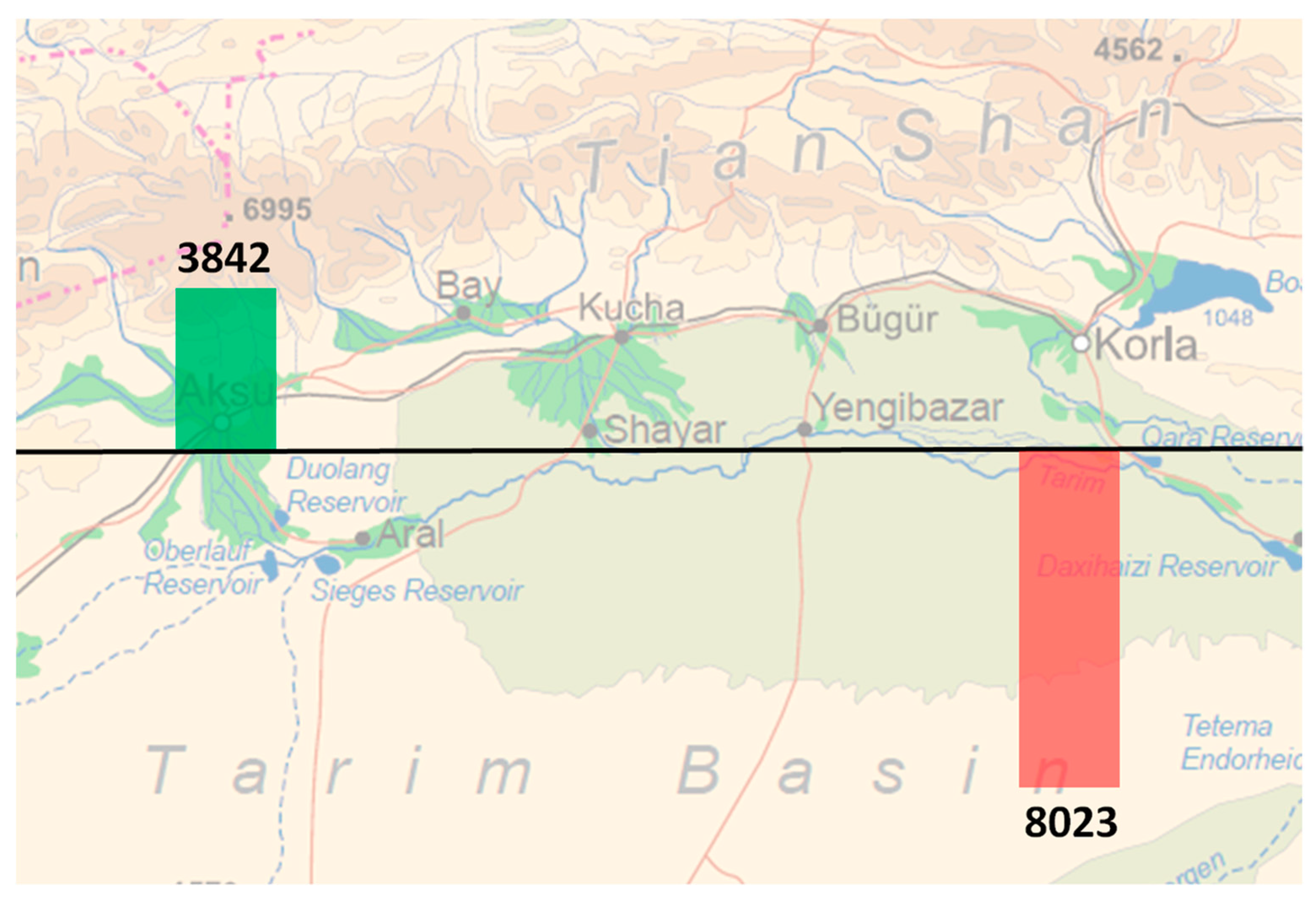
1], the difference of 922 mm for white poplar and 888 mm for orchards is attributable to irrigation. With an area of 1262 ha covered by white poplar, and an area of 2580 ha covered by orchards, the Kökyar Protection Forest thus consumes an amount of 34.519 million cubic meters of irrigation water. This is the amount of water the natural Tugai forests at the middle and lower reaches of the Tarim River are deprived of.
Since the natural vegetation is better adapted to the local hyper-arid conditions, the Tugai forests have far lower water consumption rates [
56] than the artificial plantations at Kökyar. Evapotranspiration calculations reveal an annual water consumption of only 480 mm for Euphrates poplar (
Populus euphratica). While 50 mm of this annual water consumption is covered by precipitation [
48], the difference of 430 mm has to be covered from flooding and groundwater supply of the Tarim River. Cutting the Tarim River discharge by 34.519 million cubic meters, as is done by the water consumption of Kökyar Protection Forest, thus translates into the desiccation and desertification of 8023 ha of Euphrates poplar forests at the Tarim River’s middle and lower reaches. Contrasting the upstream afforestation of 3842 ha at Kökyar with the downstream forest loss of 8023 ha shows a net forest loss of 4181 ha (comp.
Figure 5).
The Tarim Basin represents one of the last refuge areas of Euphrates poplar forests, one of the world’s rare biospheres [
17,
27]. Most animal species in the Tarim Basin, of which many are classified as endangered, rely on them and on the Tugai vegetation in general as a habitat [
17,
28,
56]. Diminishing this ecosystem by 8023 ha by upstream water extraction deteriorates the state of the natural environment considerably and aggravates the threat to the regional and global biodiversity. Single species and the ecosystem type as a whole are pushed one step closer towards extinction.
Under this light, the claim of Kökyar contributing to ecological equilibrium appears ridiculous—the precise contrary is the case: While the establishment of an artificial plantation system on a desert area close to Aksu does not represent any benefit for the natural environment, the degradation of the rare Euphrates poplar forest, caused by upstream water consumption, represents a significant deterioration. In the dimension of the natural environment, the Kökyar Protection Forest must be classified as unsustainable. However, it should be kept in mind that the greatest consumer of water is cotton production in this region.
3.2. Assessing the Social Sustainability of the Kökyar Protection Forest
The Kökyar Protection Forest is treated by prevalent literature as a guarantor for social sustainable development, with the effects of improvement of living conditions in Aksu, employment, increase of social coherence between cadres and the people, military and civilians, and between all ethnicities [
1,
2,
3,
4]. Some other claimed effects, such as patriotic and environmental education, will be excluded from consideration here.
The effect of improving the living conditions in Aksu is probably given. An improvement is perceived and described by local inhabitants [
40,
43]. Additionally, a data set from 1996 shows a decrease of annual windborne sand events from 11.4 before the establishment of Kökyar down to 4.3 since its establishment [
2]. However, the data does neither reveal the intensity and duration of each event nor the precise contribution of the Kökyar plantation to this reduction [
40]. The precise metrics of the protective effect therefore stay unknown. The reduction of the dust and sand impact on the citizens does not only imply an increase in comfort and convenience, but also an improvement of the health conditions in the city, since frequent dust and sand storms can cause lung diseases and other health issues [
57]. The provision of regulating ecosystem services for the 580,000 inhabitants of Akus City thus constitutes a step forward for the social sustainability of the city. However, as has been argued above, the regulating ecosystem services have not really been created from thin air but rather have been translocated from the Tarim River’s middle and lower reaches, because the afforestation of a certain area at Aksu entailed a forest loss in the downstream areas. This implies that downstream areas were deprived of exactly those regulating ecosystem services, leaving inhabitants of local farms and villages to a higher exposure of dust and sand storms, and consequently reducing their quality of life. Since the forest loss in the downstream areas is more than twice as big as the forest gain in the upstream area, a total reduction of overall regulating ecosystem functions can be assumed. But since the Kökyar Protection Forest is precisely located at a point where it most efficiently protects a big urban population, it probably provides its regulating ecosystem services to a far bigger number of individuals than the natural forests in the downstream areas with their relatively lower population density would have done.
Reducing unemployment and creating permanent jobs for formerly unemployed people increases social sustainability. The Kökyar annals claim that the plantation areas of Kökyar I and Kökyar II alone absorbed 3500 unemployed persons, recruiting mostly from free floating workers of the inner (Han-Chinese) provinces [
2]. This number is clearly an overstatement, since on the 623 ha of orchard area in Kökyar I, only 324 farming households got settled [
2] (estimates based on a Kökyar socio-economic household survey suggest slightly higher numbers). Extrapolating this density of 0.52 households per hectare to the orchard area of Kökyar II (578 ha) shows a potential of an estimated 301 households in Kökyar II, and 625 in Kökyar I and II altogether. Even if every household is calculated with 2 workers, the resulting 1250 workers of the farming households leave a huge gap to the claimed 3500 drawn from unemployment. Additional jobs may have been created in administration and technical management, yet they can by no means be assumed to fill this gap. Extrapolating the density of 0.52 households per hectare orchard area to Kökyar I, II and III would allow an estimation of 1340 households, or, if every household is calculated with 2 workers, 2680 work places created, plus a smaller number of jobs created in administration and technical management. While this without any doubt is a great social achievement, it is, again counterbalanced by adverse effects at the Tarim River’s middle and lower reaches. The natural Tugai vegetation there is traditionally used by autochthonous Uyghur dwellers as a grazing area for their livestock. Low intensity grazing can be regarded as a sustainable form of land use along the Tarim River [
58]. The desiccation of 8023 ha of Tugai forests, caused by Kökyar irrigation water extraction, deprives the herdsmen of the basis of their livelihoods and leads into unemployment, unless they can switch to agriculture or other economic activities. It further may lead into forced resettlement of entire villages, social dislocation, and destruction of traditional culture and lifestyle [
26]. However, since the downstream areas are sparsely populated and grazing areas per household are huge (456 ha per household in the average of a very small survey conducted at Iminchäk, Bügür County, by [
58]), the number of affected households should not exceed several dozens. Supra-regionally, the Tugai forests have a cultural significance for far more people, since their scenic beauty is well-known and appreciated all over China, as is expressed by their nomination on the Tentative List for the World Heritage Centre and UNESCO [
27]. The desiccation of 8023 ha of these forests thus also represents a certain cultural loss for a wider range of persons concerned, though in a less dramatic way than for the autochthonous inhabitants.
The Kökyar Protection Forest is claimed to increase social coherence. This claim refers to the joint obligatory afforestation work in which “all citizens, no matter which ethnicity, military and civilians” were called to take part [
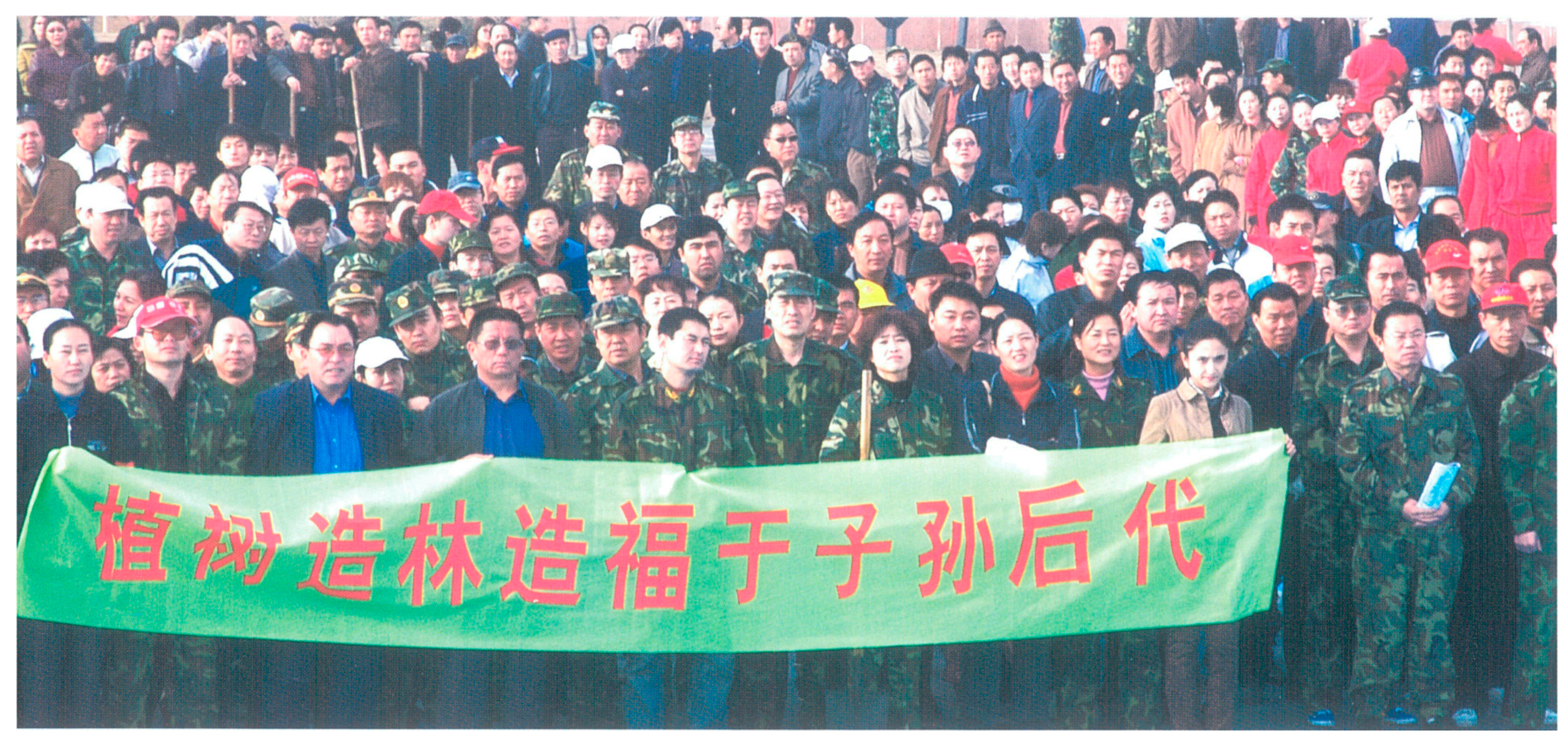
2]. Over the years, beginning from 1986, thousands and thousands of Aksu citizens had to participate in the afforestation effort [
1,
2,
40]. It had indeed been perceived as a joyful experience by some citizens of Aksu (random interviews with Aksu citizens) and might have fostered social coherence, yet, so far there are no surveys on the precise effects. On the other hand side, social coherence could be jeopardized by the fact that the losers in terms of lost income and potential unemployment are autochthonous Uyghur dwellers, while the winners are mostly Han-Chinese settlers—a socio-economic household survey conducted in Kökyar revealed that out of 19 interviewed households, 17 were Han-Chinese, and only 1 was Uyghur. If this share is representative for the whole Kökyar Protection Forest, it could be another evidence for structural discrimination of Uyghurs, adding to existing inequalities between the ethnicities [
59], and finally contributing to social unrest. Social unrest due to inequalities and ethnic tensions between Uyghurs and Han is a core problem of Xinjiang’s society [
60,
61].
Summing it up, living conditions of 580,000 inhabitants of Aksu City have been enhanced by the provision of additional regulating ecosystem services, especially the reduction of dust and sand storms, but at the cost of lost regulating ecosystem services for rural dwellers in the sparsely populated areas down the Tarim River and a consequent deterioration of their living conditions. Employment opportunities have been created for several thousand formerly unemployed people or migrant workers in and around the Kökyar orchards, yet mainly Han-Chinese settlers are benefitting of these jobs, while the livelihoods of downstream autochthonous Uyghur herdsmen are curtailed and their traditional lifestyles threatened. We can thus observe an overall increase of social benefits, but they are unevenly distributed, favouring the urban area to the rural area, and the Han-Chinese ethnicity to the Uyghur ethnicity. This uneven distribution adds to the focal problem of Xinjiang, the ethnic tensions between Han and Uyghurs. Therefore it is, despite the general social merits of the Kökyar Protection Forest, difficult to give a definitive judgement on its social sustainability.
3.3. Assessing the Economic Sustainability of the Kökyar Protection Forest
By earlier publications, all in Chinese language, the Kökyar Protection Forest is regarded as guarantor for sustainable economic development, with the effects of generation of rural incomes, and strengthening of the local economy [
1,
2,
3,
4]. The income situation in the Kökyar Protection Forest has been studied by [
40] in the area of Kökyar I. Gross income from small-scale leasehold fruit farming amounts to 78,704 CNY/ha in the long-term average, or, if extrapolated to the areas of Kökyar I, II, and III, 203.149 million CNY. Net income amounts to 47,376 CNY/ha, or 122.230 million CNY extrapolated for Kökyar I, II, and III in total. Thousands of orchard farmers enjoy a decent income through the establishment of the Kökyar Protection Forest. The precise amount of their annual incomes is hard to determine, since fruit harvests oscillate form year to year, and many farmers additionally work on Aksu City construction sites in the off-season (Kökyar socio-economic household survey). However, farming incomes per working day can be estimated at 263 CNY on the long-term average [
40]. The income situation must be satisfactory to them, since nearly all interviewed farming households were optimistic with regard to the future and declared to be willing to sign up for the next leasing period (Kökyar socio-economic household survey).
Additional incomes were created for jobs in the administration and technical management of the plantation system [
1,
2]. The governmental organisations managing the Kökyar Protection Forest can cover parts of their annual budgets from lease payments and irrigation fee payments of the farmers, and by the timber yields from white poplar in the shelterbelt strips which are fit for cutting. Still, their costs surpass these incomes, and they are dependent on regular governmental grants [
40].
A comprehensive analysis of all local monetary cost and benefit factors of the Kökyar I area revealed an annual financial net benefit for the local economy of 11.889 million CNY, resulting mainly from fruit production. This translates into an annual per-area benefit of 10,530 CNY/ha. The precise economic conditions of Kökyar II and III have not yet been researched, but since they have greater orchard shares than Kökyar I (cf.
Table 1), and since orchards are by far more profitable than shelterbelt strips, Kökyar II and III can be assumed to create even greater economic benefits than Kökyar I [
40]. Extrapolating the Kökyar I per-area benefit on the whole area of Kökyar I, II, and III would result in an annual net benefit of 40.456 million CNY, which most likely represents a considerable underestimation of the real net benefit. Establishment costs of Kökyar I ran up to 61,245 CNY/ha. The payback period can be roughly approximated at 20 years. Kökyar II and III had similar per-area investment costs, but probably have shorter payback periods due to their higher orchard shares and consequent higher profitability [
40].
Besides of these direct monetary effects, indirect monetary effects are to be expected due to the reduced exposure to dust and sand storms in the city of Aksu. Severe dust and sand storms used to stop all traffic in the city and disrupted public life, assumably also having negative impacts on the economic activities in the city [
4]. Any alleviation of this dust and sand storm situation can be assumed to have positive effects on the economy of Aksu City. Furthermore, a reduction of dust-related lung diseases also can be assumed to improve the balances of the public health systems.
Economic downsides of the Kökyar Protection Forest are, again, related to its irrigation water consumption and the consequent downstream forest loss. Uyghur herdsmen in the middle and lower reaches of the Tarim River who graze their livestock in the Tugai forests, create an income from selling excess animal offspring and mohair. Two publications on vegetation type cover and livestock density in the Tarim River’s middle reaches allow for a rough estimation of the economic value of these items [
25,
58]. The annual gross income from herding lies at approximately 44 CNY/ha. Multiplication by the forest area lost due to Kökyar water extraction shows that annual gross incomes from herding must have been cancelled in an extent of roughly 0.353 million CNY, by the establishment of the Kökyar plantation. Production costs have not been researched and net incomes are unknown. Yet, comparing the annual gross income from Kökyar fruit farming alone (at least 203.149 million CNY) with the annual gross income from herding in the corresponding Tugai areas (roughly 0.350 CNY) declassifies the latter as peanuts and shows that the Kökyar Protection Forest is by far superior in terms of economic productivity per unit of water.
Indirect economic losses can be caused by the deterioration of the regulating ecosystem services along the Tarim River. An increase in dust and sand storms can affect economic activities and increase health costs in its middle and lower reaches. However, the affected population is smaller and the affected economic activities are less profitable than in Aksu City. Sand drift blocking roads and slowing down or inhibiting traffic can cause additional economic losses, especially if they are of high relevance, such as in the case of the National Highway 218 at the lower reaches. Road protection measures also cause additional costs [
20]. In the long-term perspective, any contribution to the ongoing forest degradation and deforestation along the Tarim River’s middle reaches increases the risk of a complete breakdown of the ecosystem and its services, as it has happened in the lower reaches back in the 1970s [
17]. If the natural barrier function of the Tugai forests in the floodplain was critically impaired, the Taklimakan Desert could spread further northwards [
17], with unforeseeable consequences for cities, smaller settlements, and infrastructure.
In summary, the Kökyar Protection Forest created several thousand new income opportunities, and resulted in a considerable net benefit for the local economy by its provisioning ecosystem services, additionally enhancing the conditions of Aksu City as a business location, due to its regulating ecosystem services. The downsides along the Tarim River are, from the short-term economic point of view, comparably small. Apart from the increased abstract risk of a destabilized environment in the long-term perspective, the Kökyar Protection Forest thus appears to be sustainable within the economic dimension.
4. Discussion
The results discussion will be structured along the two research questions.
First research question: Is the Kökyar Protection Forest sustainable in the three dimensions of (a) environmental sustainability, (b) social sustainability and (c) economic sustainability?
The results regarding the sustainability of the Kökyar Protection Forest can be summarised as follows for each of the three single dimensions of sustainability: Within the economic dimension, Kökyar contributes to economic development, creating incomes for thousands of farmers and resulting in a net-benefit for the local economy, with only minor economic losses for the local economy in the downstream areas. It thus appears economically sustainable. In the social dimension, the results show a mixed record with a clear overall improvement of social conditions in terms of employment and enhanced living conditions, but also with a tendency to increase inequalities between Han and Uyghurs, thus potentially fueling the ethnic tensions between these two ethnicities and contributing to the biggest social problem of Xinjiang. Regarding the environmental dimension, the Kökyar plantation replaces a natural desert ecosystem by a completely artificial forest plantation, without any benefits for the natural environment. Due to its water consumption it simultaneously transforms double the size of its own area at the Tarim River’s middle and lower reaches, formerly covered with highly valuable natural riparian forest ecosystems, into desert. By this, it pushes an already highly threatened ecosystem type closer towards extinction and menaces global biodiversity. Within the environmental dimension, it has thus to be classified as unsustainable.
These findings underpin previous research results showing that afforestation in drylands often produces complex and large-scale social and natural impacts related to the opportunity costs of the applied water resources [
62].
According to the “Three-Nested-Dependencies Model” of sustainability, the economy is regarded to be nested in the society, and the society to be nested in the environment [
63]. This expresses the basic logic that an economy is only viable within sustainable society structures, and that a society is only viable if the natural environment is treated sustainably. According to this logic, an economic development that results in unsustainable use of the natural environment cannot be sustainable on the long run. This principle idea casts a shadow over the claimed economic sustainability of the Kökyar Protection Forest. Is an overall sustainability consequently excluded by the stated unsustainability in the environmental dimension?
In this specific case, the social and economic system that has been established in Kökyar, Aksu, is not directly embedded in the environmental system which it degrades, i.e., the Tugai forests along the Tarim River. In fact, the dramatic adverse environmental effects are so far apart, that the environmental impacts will probably not inhibit the social and economic prospering of Aksu in the short-term and medium-term.
The overall sustainability of the Kökyar Protection Forest can thus not be answered from the local perspective alone, but depends on the question whether or not its negative impact pushes the Tugai forests beyond their sustainable environmental viability within the wider region of the Tarim River catchment area. The environmental viability of the Tugai forests in the catchment area and their critical viable degree of interference and degradation can hardly be determined, due to uncertainty, non-linearity, and irreversibility, by which the internal functioning of ecosystems generally is characterised [
54]. However, the fact that the Tugai forests have already collapsed in the Tarim River’s lower ranges, and that expensive artificial measures such as large scale water diversion and massive embankment engineering are deemed necessary to revitalise them [
34,
35], gives strong indication that the ecosystem as a whole is already close to a tipping point. The redirection of water from other catchments will again have environmental consequences in this arid region.
Of course, compared to the vast areas and high water needs of the big cotton farms along the Tarim River and up its tributaries, the Kökyar irrigation water consumption alone causes only small losses of Tugai forest areas. Yet, under conditions of ongoing land reclamation and rising water consumption for agriculture, and under the absence of a central authority that effectively regulates water extraction, it adds to the general problem of water scarcity and desiccation of natural ecosystems and is thus part of the overall unsustainable water policy within the Tarim River catchment area, to say the least. A final judgement on the overall sustainability of the Kökyar Protection Forest can only be done ex post, once we know if the Tugai forests could cope with the added stress caused by the Kökyar water extraction. Under such conditions of uncertainty, decision-making should favour precaution [
54].
Second research question: Is the Kökyar Protection Forest an afforestation project or an agricultural land reclamation project?
The Kökyar Protection Forest is claimed to be an afforestation project for combatting desertification. However, the reverse is true. The comparative evapotranspiration calculations executed for the upstream Kökyar plantation and the downstream Tugai forests show that the upstream forest gain, in an extent of 3842 ha, is over-compensated by a downstream forest loss, in an extent of 8023 ha, resulting in a net forest loss of 4181 ha. The plantation thus should be labelled as a “net-deforestation” project that factually contributes to desertification. Such adverse effects are expectable wherever artificially introduced vegetation types have higher water consumption rates than the natural vegetation and an imbalance between water supply and water consumption is created [
64].
Furthermore, there is evidence for the Kökyar plantation rather aiming at agricultural productivity than at environmental protection. Firstly, as shown in the sustainability assessment presented in the results chapter, it brings harm to the natural environment, and it has both positive and negative effects on the social sphere, but it excels in the economic dimension, mainly due to fruit production. Secondly, an ecological restauration project would have needed to rely on native plant species with low water consumption and the potential of self-regulatory processes [
65]. Yet, for the Kökyar plantation mostly alien highly productive tree species with high water demand were chosen and arranged in a pattern that requires permanent management interventions and promises intensive economic exploitation. Thirdly, while in the area of the first project period, Kökyar I, the thriving for regulating ecosystem services is still recognisable by the high share of poplar shelterbelt strips with good windbreak properties, these poplar areas start shrinking in Kökyar II, and drop to only 10% in Kökyar III, in favour of increasing orchard shares (cf.
Table 1). Fourthly, the fourth project period, Kökyar IV, which is currently in development, continues on this pathway, sprawling deeper into the natural environment and further away from Aksu City that originally was to be protected, having a scheduled extent of nearly three times the area of Kökyar I, II, and III altogether (cf.
Table 1). These four points show a strong focus on agricultural production and a shrinking focus on the provision of regulating ecosystem services.
In sum, the Kökyar Protection Forest should not primarily be regarded as an afforestation project, since it creates a net forest loss and shows strong characteristics of an agricultural land reclamation project.
5. Conclusions
Also under the perception of Kökyar being primarily an agricultural project, it has undeniable merits in the social and the economic sphere which obviously encourage adopting idea and design for similar projects. In the environmental sphere however, it causes severe adverse effects in the present day, with unfathomable risks for the future, casting shadows on the future social and economic development as well. Due to the inherent uncertainty, irreversibility and non-linearity of ecosystem functioning, this trade-off between short-term socio-economic benefits and environmental costs cannot be evaluated properly, and decision-making should follow the precautionary principle [
54].
Practically, the precautionary principle could be applied, and all environmental downsides could be removed, by any means that would decouple the Kökyar Protection Forest from the destructive logic of ever-increasing water consumption and the resulting desiccation of the Tugai forests along the middle and lower reaches of the Tarim River: (A) Potential solutions could lie in the establishment of a central authority that effectively regulates and harmonises upstream and downstream water consumption and allocates sufficient water resources to the natural ecosystems. (B) In the absence of an effective central regulation of the catchment area, the local government of Aksu could locally counterbalance the Kökyar water consumption by taking other agricultural areas with less side benefits, e.g., cotton plantations, out of irrigation in an amount that compensates the Kökyar water consumption. (C) A similar effect could be achieved by substituting cotton by the cultivation of locally adapted more water efficient crops, such as jujube (
Ziziphus jujuba) as an orchard tree, and dogbane (
Apocynum pictum) as a fibre plant [
66,
67].
Potential future afforestation projects in the drylands of Central Asia should carefully consider the unintended side effects observed in this case study on the Kökyar Protection Forest, i.e., the downstream forest loss resulting from upstream afforestation, and the consequent translocation of ecosystem services.
Studying other allegedly environmental afforestation projects in South Xinjiang with regard to their water provenance and potential conflicts with the natural ecosystems could be worthwhile.


