Article

A Framework for Assessing the Impacts of Mining Development on Regional Water Resources in Colombia

1
Centre for Water in the Minerals Industry, Sustainable Minerals Institute, The University of Queensland, Brisbane QLD4072, Australia
2
Geosciences Department, University of Los Andes, Bogota 111711, Colombia
3
Environmental and Civil Engineering Department, University of Los Andes, Bogota 111711, Colombia
4
School of Mines, Universidad Nacional de Colombia, Medellin, Colombia
*
Author to whom correspondence should be addressed.
Water 2018, 10(3), 268; https://doi.org/10.3390/w10030268
Submission received: 24 January 2018 / Revised: 28 February 2018 / Accepted: 1 March 2018 / Published: 4 March 2018
(This article belongs to the Special Issue Water Stewardship in Mining Regions)

Abstract

:
Developing its large-scale mining industry is an economic priority for Colombia. However, national capacity to assess and manage the water resource impacts of mining is currently limited. This includes lack of baseline data, lack of suitable hydrological models and lack of frameworks for evaluating risks. Furthermore, public opposition to large scale mining is high and is a barrier to many proposed new mining projects mainly because of concerns about impacts on water resources. There are also concerns about impacts on the uplands that are important water sources, particularly the páramo ecosystem. This paper argues the case for a new framework for Strategic Assessment of Regional Water Impacts of Mining, aiming to support land use planning decisions by government for selected mining and prospective mining regions. The proposed framework is modelled on the Australian Government’s Bioregional Assessments program, converted into seven stages plus supporting activities that meet the Colombian development context. The seven stages are: (1) Contextual information; (2) Scenario definition; (3) Risk scoping; (4) Model development; (5) Risk analysis; (6) Database development; and (7) Dissemination by government to stakeholders including the general public. It is emphasised that the process and results should be transparent, the data and models publicly accessible, and dissemination aimed at all levels of expertise.

1. Introduction

Colombia is an example of a nation where mining makes a significant contribution to local and national economies [1]. Due to the abundant resources present in the ground, including coal, gold, nickel and platinum (Figure 1), there are good prospects for further development. However, the impacts of mining projects can include reduced access to good quality freshwater for other economic activities and/or biodiversity preservation [2,3,4]. The history of impacts caused by poorly managed mining combined with general public opposition to large scale mining have created strong public and political resistance to mining development [5,6].
For legal mine projects, mine companies conduct environmental impacts assessments that should provide evidence that impacts will be managed according to international best practice. This includes a general description of the project, definition and characterisation of areas of influence, description of the natural resources to be used, demanded and impacted, environmental assessment, and the description of the plan to manage and mitigate environmental impacts [8]. However, prior to the assessment of individual project proposals, national governments generally undertake strategic land use planning, which results in decisions about whether or not new mines, even those capable of employing best practice, are acceptable in a particular region [9]. This includes broad considerations, including employment, infrastructure, native communities and potentially conflicting land uses [9,10,11]; however, the potential impacts on water resources and related ecosystem services are often pivotal considerations. This is the case in Colombia, where water is at the centre of the debate over whether and where new large-scale mines should be opened [12].
This paper addresses the challenge of developing a sustainable mining industry for Colombia by proposing a framework for assessing the impacts of mines on regional water resources. If implemented in a region, the framework outputs would provide government and other stakeholder groups the scientific evidence needed to inform their viewpoints about mining development in that particular region, and a baseline from which to design a program of priority scientific research into mining impacts. This paper includes (i) a review of the Colombian context for decisions around mining development and assessing water impacts of mining; (ii) a description and discussion of the proposed framework; (iii) a comparison to Australia’s Bioregional Assessments [13], on which the proposed framework is modelled; and (iv) review of the practicality of applying the framework using an example in the Colombian coal mining regions of Cundinamarca and Boyacá.
The proposed framework focusses on the potential impacts of medium to large scale mines, including alluvial, open-pit and underground mines. The scope of the framework includes mining of coal, metal ores and all other minerals. Predicting the potential impacts of small scale mines on water resources, although also a major challenge in Colombia [14,15], is outside the scope of the present study. A neutral scientific view on mining impacts is taken, with the recognition that mining, done in the right place in the right way, with an acceptable level of risk to water resources, could be a legitimate and economically important industry for Colombia.

2. Mining in Colombia

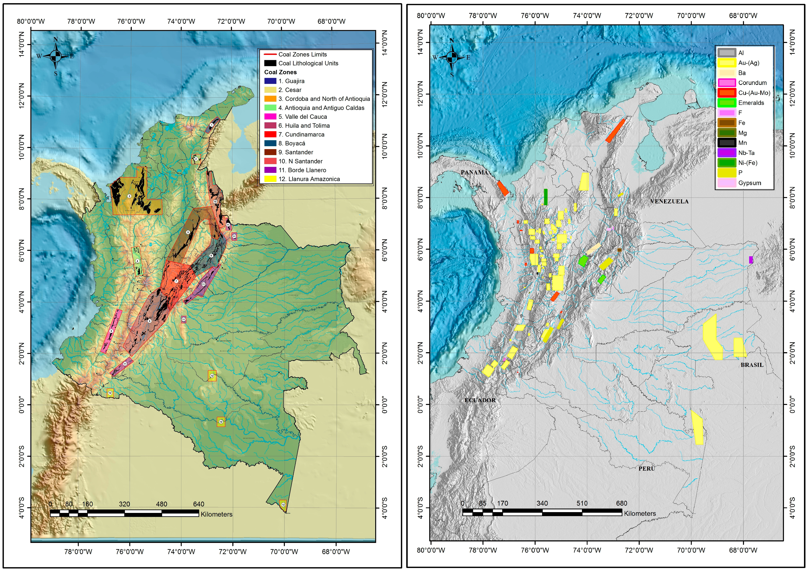
2.1. Mineral Production and Reserves

Mining contributes approximately 2% of Colombia’s national Gross Domestic Product [15]. Coal mining dominates and is focussed in the Guajira and Cesar regions (Figure 1), which jointly produce up to 80 million tons of (mainly thermal) coal per year. Other regions—Cundinamarca, Boyacá, Santander, Norte de Santander, Cordoba, Antioquia and Valle del Cauca (Figure 1)—jointly produce 6.3 million tons of (mainly metallurgic) coal. The Colombian government expects national coal production to increase by approximately 15% in the period 2017 to 2021. Mining of other minerals is smaller in terms of economic contribution. For example, in 2015 Colombia produced approximately 900 kt of iron, 37 kt of nickel, 60 t of gold, 10 t of silver, 861 kg of platinum and approximately 2 Mct of emeralds for export [16,17]. Production fluctuates from year to year, mainly in response to global demand and prices. Confirmed mineral reserves include gold, iron, copper and nickel [18,19], while less well quantified reserves of emeralds, clays, manganese, phosphates and other minerals also exist. The principal prospective mining regions are shown in Figure 1.

2.2. Regulation of Mines

Currently the Ministry of Mines and Energy through the Vice-Ministry of Mines is responsible for formulating governmental policies on the mining sector, supported by related entities. The National Agency of Mines (ANM) is responsible for certification, registration, technical support, promotion and supervision of mining titles. The Mining-Energy Planning Unit (UPME) is responsible for the planning of mining development, including producing and disseminating information to mining stakeholders. The Colombian Geological Survey (SGC) conducts scientific research on the mineral resources. Before beginning operations, mining companies need an environmental license issued by the Regional Autonomous Corporations for small to medium scale mining projects, or by the National Authority of Environmental Licenses for large scale mining projects.
An environmental license is mandatory for every mining project, often supplemented by discharge and extraction licenses. Additionally, the constitutional ‘popular query’ (Colombian Const. art. CIX) gives local communities the right to vote in favour or against a project [6]. When a mining project is voted against, although not necessarily preclusive, in practice it has proven difficult to continue.

2.3. Water-Related Challenges of Colombia’s Mining Industry

Globally, mining regions pose some special challenges for water impacts assessment [3,20,21,22]:
  • The longevity of the mine lifecycle (exploration, construction, mining, rehabilitation, closure), hence the need for long-term predictions of the mine’s interaction with the environment.
  • The intrusions into the groundwater system, in particular the potential for drawdowns in groundwater levels due to mine pit dewatering. This requires an advanced understanding of hydrogeology around the mine and how to model its interaction with the mine across multiple scales.
  • The potential release of contaminants (salts, metals and/or acids) from mine wastes due to the exposure of previously buried rocks to air and water.
  • The radical change to the surface landscape caused by mining can alter hydrological and sediment regimes and the ecosystem services they provide, through surface water-groundwater interactions, river diversions and other alluvial disturbances.
As well as these globally relevant challenges, Colombia has particular challenges associated with its biophysical and socio-political traits. Mainly, these are: (i) the variable and generally wet climate; (ii) the debate over protection of the páramo areas; and (iii) the polarised public opinions on mining.
Colombia is a generally wet country. Annual average rainfall values in the Pacific coastal regions that overlap with mining regions can reach 10,000 mm [23,24,25]. This creates management challenges associated with excess water, for example the prevention of flooding of mine pits, dam stability, erosion and containment of mine-affected water. Other regions are semi-arid, where mines have water deficits, requiring abstractions from aquifers or rivers that have the potential to affect water availability for traditional uses [26]. Land use change in many regions is dynamic including rapid development of agriculture and the development and abandonment of small scale mines [27]. This adds to the difficulty of predicting and monitoring the impacts of new, larger scale mines.
The value of ecosystem services provided by prospective mining regions also creates challenges both in mine planning and operational water management. The Amazonas and challenges of mining in that region are well-publicised [28,29,30]. Furthermore, also well-known are the ecosystem services provided by the páramos, the headwater wetlands from which about 70% of Colombia’s water supply originates [31,32]. While regions with high mineral reserves (Figure 1) overlap páramo areas, in February 2016 the Constitutional Court forbade mining in páramo using the páramo delimitation by [33]. However, many companies have contested this, mainly due to disputes about the definition of páramo and lack of consideration of existing mining projects, for example [34]. As well as potential intrusion of mining activity onto páramo, there are potential risks to its water supply value from air-borne dust and contaminants from mining and coking in nearby areas [35].
Colombia also has particular challenges related to the strong, polarised preconceptions on mining and its impacts on water. On the one hand, there is recognition that new large-scale mines are important for Colombia’s economic development, and it is argued that mining can take place if using established best practice approaches that minimise or neutralise adverse impacts [36]. On the other hand, there is deep distrust of the motivations of mining companies and distrust of the sector’s ability to operate effectively while having minimal adverse impacts [37]. This is more so in Colombia than in other countries due to the corruption, exploitation, pollution and illegal activity that has been strongly associated with the unregulated mining sector and is likely to persist for some time [38]. The conclusions from any impact assessment study, whether implying that mining development is conditionally appropriate or unconditionally inappropriate in a particular region, are likely to face high levels of scepticism and scrutiny of the credentials and motivations of the assessment. Furthermore, Article CIX of the Constitution empowers the public to block new mine projects. Hence, distrust of the mining sector is a more palpable barrier to development than in many countries.

2.4. The Need for a Guiding Framework

Although the problems of mercury emanating from small scale mines has been relatively well studied [2,39,40], overall there is a lack of evidence about the impacts of mines on water resources in Colombia. In the mining region of Boyacá, it was found that watercourses were polluted with mercury, lead, iron, magnesium, manganese and aluminium, with concentrations not meeting water quality standards [41]. Similarly, near the border of Boyacá and Cundinamarca, high concentrations of sulphates, sodium, potassium, magnesium and manganese have been measured [42]. While such studies contribute to understanding the pollutants that may be associated with mining, in general there is a lack or absence of publicly available hydrological and geochemical data needed to promote understanding of the existing and potential impacts. Research has been ad-hoc, rather than coordinated to develop scientific understanding and baseline data sets. This is partly due to conflict and security problems that have restricted monitoring, a problem alleviated by the peace agreements in 2016. The lack of data and models is also partly due to limitations in national capacity, which although good in water resources and environmental science, is low in terms of ability to apply these disciplines to predicting mining impacts [43]. This mirrors more general concerns about Colombia’s lack of capacity to monitor ecological change associated with rapid socio-economic development [44].
The lack of understanding about the impacts and potential impacts of mining, and how they can be managed, needs to be addressed as part of a strategic program of education, monitoring and research [43]. As part of this, there is a need for a framework that guides the development of baseline data sets and impact assessment models. The rest of this paper suggests such a framework, which we call Strategic Assessment of Regional Water Impacts of Mining (SARWIM).

3. Outlining a Framework for SARWIM in Colombia

3.1. Principles for Developing a Framework

Although the approach to SARWIM must account for the context of the specific mining region in question, guiding principles include:
  • It should be founded on good practice modelling procedures and data management protocols. An important part of this is recognition of uncertainty and the need to list key assumptions, and evaluate and report uncertainty in a transparent manner. It is usually convenient for a regional scale water impacts assessment to be conducted on river and/or groundwater basins with the view that physical impacts will be negligible beyond the basin boundaries (although in some cases off-shore impacts are also considered).
  • It should be risk-based. This includes prioritising the types of impacts considered based on expert consensus of the associated level risks; and relating the effort devoted to each risk to the perceived level of risk. This recognises that it is impossible to address all risks present.
  • It should not attempt to replace more detailed, local scale impacts assessment that should be encompassed in project environmental impact assessments. This involves the acceptance that local biophysical properties and processes, and site-specific mining methods and water management practices may not be accurately included in the regional scale analysis; and hence that the results indicate effects that are likely region-wide and not predictions of what will occur locally.
These principles are embodied into various strategic water and environment assessment guidance documents for the mining industry and other sectors, for example [45].

3.2. An International Benchmark

The Australian Bioregional Assessment program has been under development since 2013 by the Bureau of Meteorology, Commonwealth Scientific and Industrial Research Organisation and Geoscience Australia [13]. The program may be considered, globally, the most ambitious attempt to quantify the risks to regional water resources arising from mining and gas development. Based on earlier concepts of Bioregional Assessments [46], the Australian program is driven by the need to have scientifically defensible and publicly accessible data and models to guide national government oversight of regional planning decisions. Its objective is to analyse the risks associated with changes to water-dependent assets that arise in response to coal and coal seam gas mine development, and to provide transparent information to allow stakeholders to develop informed opinions about risks.
The Australian Bioregional Assessment program consists of five stages: (1) Developing a database and describing the regional context, mainly based on using existing data sources; (2) Preliminary analysis of the data; (3) Development of conceptual models including prioritisation of risk sources, scenario development, development and assessment of numerical models including uncertainty analysis, and defining the mining and gas project development scenarios to be examined; (4) Impacts analysis, usually including cumulative impacts of multiple mines and gas fields; (5) Risk evaluation, including the translation of predicted hydrological impacts and their uncertainties into economic and ecological risks. An important feature of the Australian Bioregional Assessments is the establishment of baseline data sets and models, where ‘baseline’ means the recognition that the data sets and models can and should be improved. Making the results, models and data available to the stakeholders, scientists and the public is a unique attempt to provide a transparent baseline upon which anyone may review, criticise and improve.
The rest of this paper explores how the Australian framework may be converted into a SARWIM suitable for the Colombian context.

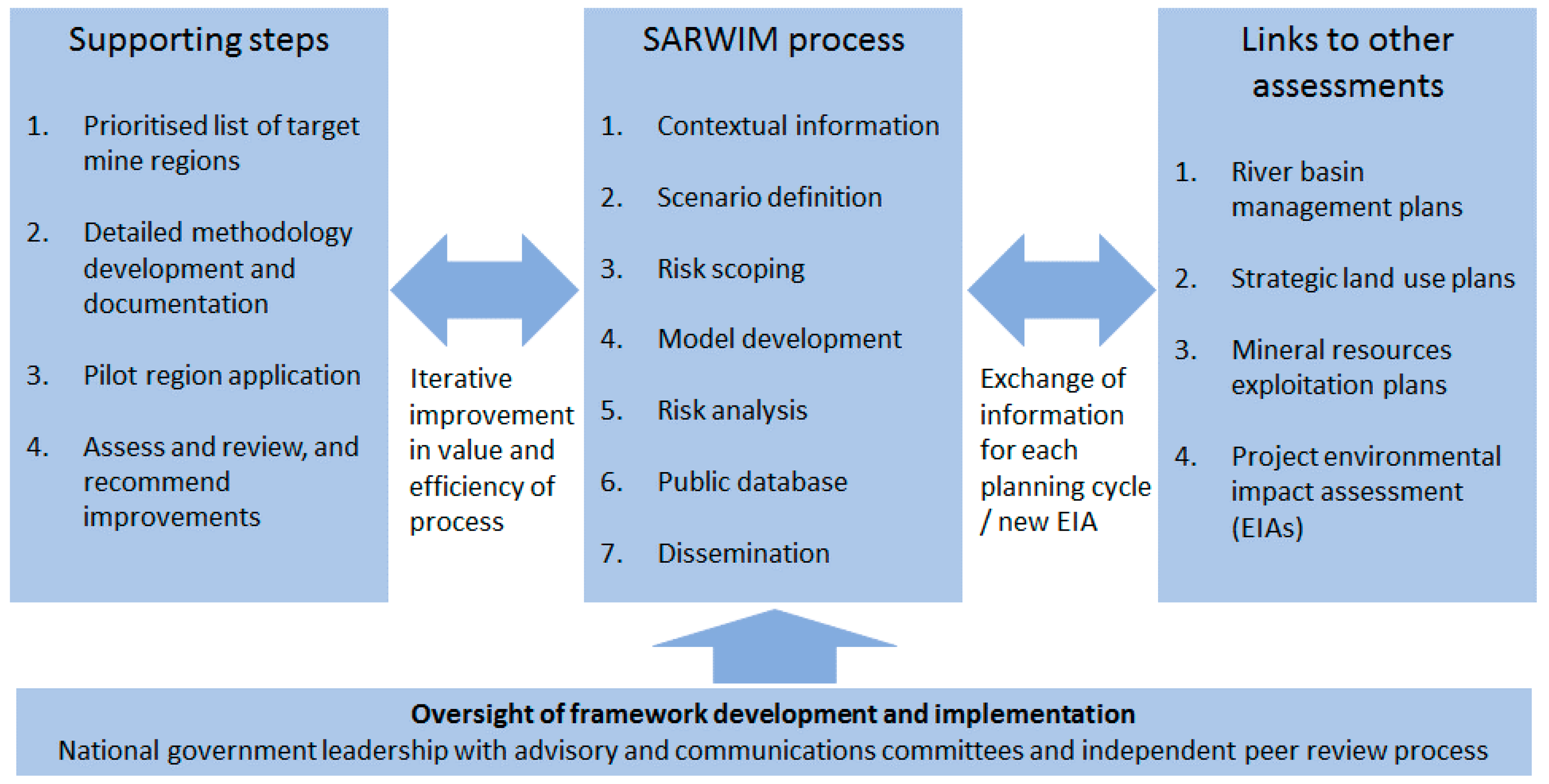
3.3. Seven Stages of SARWIM

We propose seven stages of impacts assessment and supporting activities listed in Table 1 and shown in Figure 2. These seven stages are adapted from [13] and aspects of the good practice environmental modelling principles from [47].
The aims and content of each of the seven stages are included in Table 1. Important elements, included in Stage 1, are the early assessment of context and data availability, developing scenarios of mining development (and potentially other important land and climate changes) and prioritisation of types of risks. These are critical because the scope of the impacts assessment and the approach used must be closely linked to the data and other resources available, and to the priority risks to be addressed in a particular region’s context. For example, even though a particular risk may be judged as present, it may be appropriate to omit it from the analysis, or assess it qualitatively instead of numerically, due to lack of supporting data or other (e.g., computational or human) resources. However, where priority risks are omitted it should be recommended that the necessary data and models be developed prior to a future round of assessments.
Although the seven stages in Table 1 are presented as sequential, in some cases it may be appropriate to return to previous stages. For example, the resources and data required to achieve satisfactory numerical modelling results may not become apparent until the model performance is assessed. There may be feedback from stakeholders after public dissemination that requires adjustments to the water-dependent assets considered, although it is intended that this be avoided by including a suitable range of experts in the panels used to prioritise the risks. In other cases, it may be efficient to run stages in parallel. In particular, the development of the database and dissemination activities, although presented as the last two stages, should run in parallel with all stages to facilitate data management and transparency.
The publicly available database is another important aspect of the proposed SARWIM framework. It is recommended that restrictions on access to the data sets and models used in the SARWIM should be minimised. This allows transparency regarding how the risks have been prioritised and assessed, and also makes the information available to build upon and improve, should any stakeholder have the desire and resources to do so. A potential obstacle is that the organisations providing the necessary data sets and models may do so under licenses that exclude open access. For such data sets and models, meta-data can be provided, including instructions on how to obtain the data or model.
Dissemination is the final stage, aiming to maximise the influence of the work by informing stakeholders, including land use planners, policy-makers, scientists and communities. A hierarchy of reports will satisfy the different needs of these audiences. At the highest level, full reports on each region will be published, supplemented by scientific papers and the method specifications. At the next level, more accessible summaries will be provided for each analysed region, which contain summaries of all six prior stages in the process. Finally, briefing documents will be prepared focusing on communicating key information to public and decision-makers. While the latter two documents will have the widest audience, this hierarchy allows different levels of insight and critical review, up to interrogating the underlying data sets and models.

3.4. Supporting Activities

The supporting activities that underpin the proposed framework are shown in Figure 2. This includes methodology documents. These do not aim to be prescriptive about the exact data sets and analysis methods to be used, which must be considered depending on each region’s context. Instead the methodology documents should specify what approach should be taken to identify the suitable methods, and may suggest methods. For example, they may specify a list of information that must be provided about each data set; stakeholder groups that should be consulted and included in risk prioritisation workshops; flow charts that specify the process for selecting a model; and requirements of model outputs such as a statement of uncertainty.
The prioritisation of regions for assessment must be made by the government ministry running the program, with advice from an expert steering committee. The priority regions are likely to be those with impending decisions regarding developing new mining on a large scale, or changing existing mining activity. The pilot region should represent such a region, but also be one where the complexity (land use, geology, etc.) and available data are not preclusive to conducting all seven stages. The completion of pilot studies will permit refinements to the methodology, and provide an example to guide subsequent SARWIM applications.
Capacity building is necessary to support the application of SARWIM. While the SARWIM should be developed in the short-term, using available national expertise and international partnerships where necessary, their effective application and integration with river basin planning will rely on engineering and environmental experts trained in mine water management. Significant opportunities for this capacity building come with the SARWIM process and outputs. The databases developed will provide a basis for tertiary education into impacts assessment as part of engineering and environmental science programs. The case studies provide an opportunity for post-graduate research, which, while not necessarily contributing to the outputs of the SARWIM, can address the scientific challenges encountered and develop the expertise base. The outputs, disseminated effectively, will provide education to the general public about regional scale mining impacts on water resources.

3.5. Links to Regional Land and Water Planning, and Mine Project Assessments

The potential links to other land and water use planning frameworks are shown in Figure 2. A question that must be addressed in designing a SARWIM program is “Should it be solely mining impacts that are explored or should scenarios involve other land use changes?” Restricting the analysis to mining development, with other land uses held constant at values for a selected baseline year, allows easier modelling and communication of the potential impacts of mining. However, that approach would not permit interactions of effects to be explored, for example encroachment of agriculture into páramo may reduce the ability of the catchment to absorb and dilute mine wastes [48]. Solely looking at mining also misses the opportunity to use the same models and databases to carry out a more integrated land use impacts assessment. It is assumed in this paper that the main issue of land use impacts on water resources in the target regions is mining. If this is not the case—if agricultural development or any other change is predicted to have major effects—then there may be a case to integrate one or more other types of changes into the scenarios used.
The interaction of mining and other land use changes may be managed through incorporating SARWIM into broader River Basin Management Plans, called in Colombia Planes de Ordenamiento y Manejo de Cuencas Hidricas (POMCA) [49,50]. These POMCAs have six phases (planning, diagnostic, prospective, formulation, execution, and evaluation). It is proposed that the SARWIM process should be done alongside River Basin Management Plans (where these exist) and ideally should share the same databases, scenarios, hydrological models, and involve many of the same stakeholders.
The interaction of a SARWIM with individual project impacts assessment also needs to be clarified. As previously noted, the SARWIM is not intended to replace project level environmental impact assessment. For example, based on the Australian experience, the grid scale of models is likely to be in the range 1 to 25 km2. This resolution is unlikely to adequately resolve the groundwater drawdowns, groundwater surface water interactions, and dilution of discharges near to mine projects. Therefore, the SARWIM results are most useful to estimate impacts of mines over regions larger than about 200 km2, where errors are smoothed out over multiple modelling grids and often more than one mine. Permissions for individual mines should be based on a more local scale environmental impact assessment. However, the SARWIM should utilise data regarding mine footprint, water use and emissions from available project assessments.

3.6. Process Oversight

The seven stages should be overseen by a suitable part of national government, who facilitate a program expert steering committee to direct the program of work, and who will appoint a science advisory committee to oversee quality of the science including an external peer review process (Figure 3).
As introduced earlier in this paper, public attitudes to the large-scale mining industry in Colombia are strongly polarised. To contribute to managing the polarisation of viewpoints, it is essential that the proposed framework—including the oversight arrangements, type of contractors appointed to undertake the analysis, funding sources, dissemination and access to the underlying data and models—be carefully designed and managed to counter as far as possible the argument that the process is biased towards or against mining development.

3.7. Discussion—Comparison of the Proposed Framework with the International Benchmark

The concept of the proposed SARWIM framework is based closely on the Australian Bioregional Assessments. These are aimed at coal resource development, including coal mines and coal seam gas (coal bed methane). This is because the prevailing regional planning questions involving cumulative impacts are in that realm, and there is limited scope for interaction of coal resource development with other forms of mining. In Colombia, the range of commodities with good prospects for large scale development is wider, with considerable scope for interaction between different types of mines. Colombia also has good long-term prospects for coal bed methane development, and ultimately there may be a case for including it in the scope. However, cumulative impacts of gas extraction alongside mining are not yet seen as a priority.
A characteristic of the Australian Bioregional Assessments is the focus on negative impacts. In addition, in our SARWIM proposal for Colombia, it is necessary to omit scenarios of positive impacts related to mine-specific activities such as providing new water supplies to affected communities, simply because these are too project-specific and unpredictable at the strategic planning stage. However, unlike in Australia, potential regional scale impacts in Colombia include changes to small scale and illegal mining. This includes potential assimilation of these mines into new, larger projects, and other support for implementing good practice supported by the new project. This is an important strategic planning consideration in Colombia particularly for sediment and contaminant management. It is important that including such scenarios is considered at Stage 2 of the process (Figure 3; Table 1). The potential additional complexity of scenarios means that a whole stage is dedicated to scenario definition unlike in the Australian case.
In application, there are likely to be some major differences between the Australian Bioregional Assessments and a Colombian version. The former is ambitious with respect to quantifying the ecological impacts of hydrological change, including the conversion of expert beliefs about connections between hydrology and ecological indicators into mathematical models, along with a formal model estimation procedure. This reflects the high priority given to ecological impacts of mining in Australia. When applied to Colombia, it is likely that greater effort will initially need to be directed at quantifying impacts on water-dependent assets with the most direct and strongest links to human health and well-being. Furthermore, the Australian Bioregional Assessments are conservative regarding predicting impacts of water quality changes, generally choosing to omit water quality risks on the basis that good practice mining should adequately manage these risks. With the history of contamination of water in Colombia due to poor water management, more explicit attention to water quality risks will be called for. Water quality issues to be addressed may include salinity, acid mine drainage, suspended solids and emissions of chemicals used in minerals processing. This significantly changes the priorities for data collection, assumptions necessary for scenario analysis and modelling from the Australian experience.

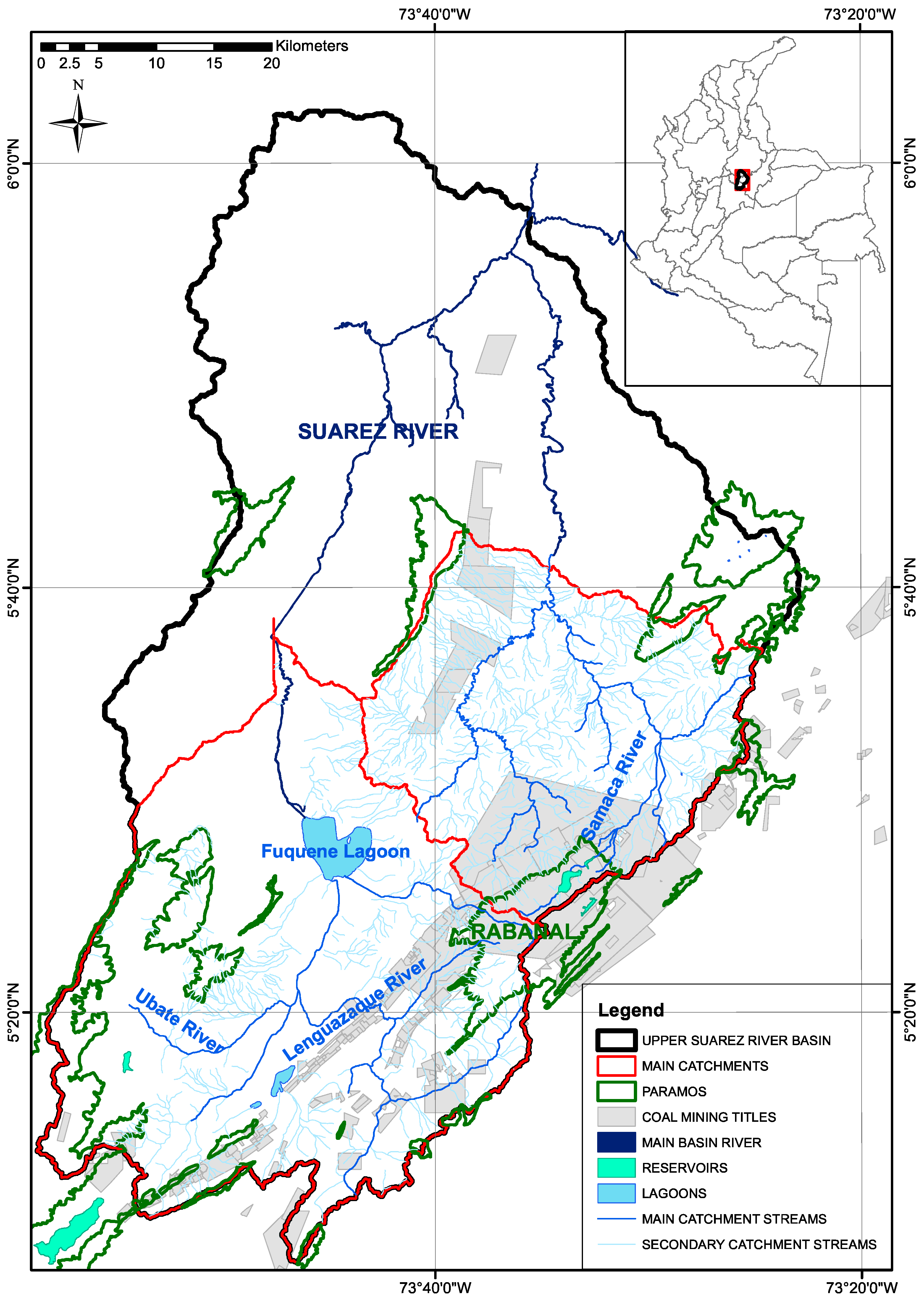
4. An Exploratory Case Study

To explore the availability of public data to support the completion of Stage 1 of the proposed framework we conducted a case study consisting of two neighbouring catchments, of the Samarca and Ubate Rivers, in the departments of Cundinamarca and Boyacá (Figure 3). Cundinamarca and Boyacá, after the Guajira and Cesar regions, have Colombia’s largest known coal reserves. The main economic activities in these catchments are coal mining, including extraction and coking activities, agriculture and the dairy industry. Land cover accounts for 67% of the total land area, páramo areas 16%, forests excluding páramo areas 11%, and other land covers 6% [51,52]. Between 1998 and 2006, the area of natural forests decreased by 27% and páramos by 50% to make way for agriculture [53]. In some areas, páramo areas are mixed with farming activities.
In Cundinamarca and Boyacá, 96% of existing water extraction licenses are for surface water extraction and 4% are for groundwater extraction. Groundwater is primarily used by the food industry, for mining activities and for irrigation; and surface water for energy generation, municipal aqueducts, and industrial activities including mining, cattle raising, and agriculture. Several reservoirs and lagoons, that are part of the upper Suarez River basin, have biodiversity and water supply value. This area was selected due to the social, land use, conservation and environmental conflicts centred around existing mining and potential for future mining.
The main categories of datasets needed to implement the proposed framework, along with the information that is known to be available, are shown in Table 2. This shows that for the case study, substantial data exist for all of the categories. However, Table 2 also notes several issues with data completeness, quality and access, which would need to be overcome prior to completing Stage 1 of the framework. This is likely to require further negotiations for data access, data purchase and statistical modelling to infill missing data. An issue, which is likely to be nationally relevant, is the lack of environmental data prior to mining. This means that either baseline conditions must be defined under existing (2017) land use or by hind-casting using numerical models.
The data limitations are being addressed within continuing projects by the Universidad de los Andes. This includes the use of remote sensing data that are increasingly suitable for mining impacts analysis [54]. However, for the development of data sets to support pilot SARWIMs, new collaborative, nationally coordinated collaborations between universities, government ministries and industry will be needed.

5. Conclusions

Colombia faces economic opportunity through development of its formalised mining sector. Mining, however, is necessarily intrusive on the environment, and opposition to further development is largely due to concerns regarding potential impacts of mining on freshwater availability, biodiversity and other hydrological ecosystem services. These concerns should be addressed by a hierarchy of planning and operational controls to manage impacts: strategic land use planning to identify regions that are suitable for mining; effective environmental impact assessments that identify where and how mines can be developed within these regions; good practice water management in mines that are permitted; and national capacity building to facilitate all these controls. This paper focussed on the former, proposing a framework for regional scale water impacts analysis as part of strategic land and water use planning for Colombia.
The proposed Strategic Assessment of Regional Water Impacts of Mining (SARWIM) framework for Colombia is modelled on the Australian Government’s Bioregional Assessments, extended to encompass all types of large scale mining. The SARWIM framework is a series of steps (Table 1) that progress towards characterising risks to water dependent assets due to existing and new mining activity. Implementation of the framework should be supported by training of staff who will implement the frameworks, methodology statements, pilot studies of key mining regions, evaluation and refinement of the steps, and prioritisation of further regions to be analysed. The proposed framework would provide an opportunity for a credible science base to inform decisions regarding mine region planning, including new mine development; and would provide data and models to support capacity building. Challenges to be overcome during pilot study implementations include: quality and completeness of data sets; access to data and models; identifying a suitably simple yet credible set of assumptions that make impact analysis practicable at regional scales while using available data; and achieving trust in the assessment process over multiple stakeholder groups. Despite the challenges, we strongly believe that experienced, creative and interdisciplinary teams can develop and implement the framework, and that this will contribute significantly to prospects for an economically, socially and environmentally acceptable mining industry in Colombia.
This paper has presented a scientific perspective on the way forward for addressing nationally pressing questions around water impacts of large scale mining. The paper provides a basis for discussion, refinement and extension of the framework proposal, followed by implementation by the national government, academic sector and mining companies. More urgently, the paper presents the need for a set of case studies to test and demonstrate the approach, along with nationally coordinated research to develop the baseline data sets and models.

Acknowledgments

This work was conducted as part of the project “Establishing a Centre of Excellence in Sustainable Mining in Bogota”. This project is supported by: the Australian Government through the Council on Latin American Relations (COALAR) of the Department of Foreign Affairs and Trade; the Vicerrectoría de Investigaciones, University of Los Andes; and the Australian Research Council through the Future Fellowship of Neil McIntyre, FT140100977.

Author Contributions

Neil McIntyre and Mario Fernando Angarita Vargas conceived and drafted the paper. Mario Fernando Angarita Vargas, Nicolas Fernandez Acosta, Luis Alejandro Camacho Botero, Jillian Pearse and Carme Huguet conducted the research to formulate the case study of Cundinamarca and Boyacá. These five authors and Oscar Jaime Restrepo Baena and Juan Ossa Moreno advised on the Colombian context and regulatory framework. Mario Fernando Angarita Vargas, Nicolas Fernandez Acosta and Juan Ossa Moreno conducted additional literature review. All authors edited the paper drafts.

Conflicts of Interest

The authors declare no conflict of interest.

References

  1. Krentz, A. Mining in Colombia. In Perspectives on Business and Economics; Volume 31: Colombia: From Crisis to Renewal; Lehigh University: Bethlehem, PA, USA; Available online: https://preserve.lehigh.edu/perspectives-v31/5 (accessed on 21 November 2019).
  2. Olivero, J.; Solano, B. Mercury in environmental samples from a waterbody contaminated by gold mining in Colombia, South America. Sci. Total Environ. 1998, 217, 83–89. [Google Scholar] [CrossRef]
  3. Younger, P.L.; Wolkersdorfer, C. Mining impacts on the fresh water environment: Technical and managerial guidelines for catchment scale management. Mine Water Environ. 2004, 23, s2–s80. [Google Scholar]
  4. Huertas, J.I.; Huertas, M.E.; Izquierdo, S.; González, E.D. Air quality impact assessment of multiple open pit coal mines in northern Colombia. J. Environ. Manag. 2012, 93, 121–129. [Google Scholar] [CrossRef] [PubMed]
  5. Vélez-Torres, I. Governmental extractivism in Colombia: Legislation, securitization and the local settings of mining control. Political Geogr. 2014, 38, 68–78. [Google Scholar] [CrossRef]
  6. Vittor, L. Indigenous people and resistance to mining projects. ReVista (Camb.) 2014, 13, 50–52. [Google Scholar]
  7. Servicio Geológico Colombiano. El Carbón Colombiano—Recursos, Reservas y Calidad, 2nd ed.; Publicación Geológica Especial 32; Servicio Geológico Colombiano: Bogotá, Colombia, 2012. [Google Scholar]
  8. Referencia Para la Elaboración del Estudio de Impacto Ambiental—EIA Proyectos de Explotación Minera. Available online: www.minambiente.gov.co/index.php/normativa/resoluciones (accessed on 30 December 2017).
  9. Jones, C.; Baker, M.; Carter, J.; Jay, S.; Short, M.; Wood, C. (Eds.) Strategic Environmental Assessment and Land Use Planning: An International Evaluation; Earthscan: London, UK, 2005. [Google Scholar]
  10. Hilson, G. An overview of land use conflicts in mining communities. Land Use Policy 2002, 19, 65–73. [Google Scholar] [CrossRef]
  11. Lechner, A.; McIntyre, N.; Witt, K.; Raymond, C.; Arnold, S.; Scott, M.; Rifkin, W. Challenges of integrated modelling in mining regions to address social, environmental and economic impacts. Environ. Model. Softw. 2017, 93, 268–281. [Google Scholar] [CrossRef]
  12. Cardoso, A. Behind the life cycle of coal: Socio-environmental liabilities of coal mining in Cesar, Colombia. Ecol. Econ. 2015, 120, 71–82. [Google Scholar] [CrossRef]
  13. Barrett, D.; Couch, C.; Metcalfe, D.; Lytton, L.; Adhikary, D.; Schmidt, R. Methodology for Bioregional Assessments of the Impacts of Coal Seam Gas and Coal Mining Development on Water Resources; A Report Prepared for the Independent Expert Scientific Committee on Coal Seam Gas and Large Coal Mining Development through the Department of the Environment; Office of Water Science: Canberra, Australia, 2013.
  14. Sarmiento, M.; Giraldo, B.H.; Ayala, H.; Urán, A.; Soto, A.C.; Martinez, L. Characteristics and challenges of Small scale Gold Mining in Colombia. In Small Scale Gold Mining in the Amazon; Cremers, L., Kolen, J., De Theije, M., Eds.; CEDLA: Amsterdam, The Netherlands, 2013; pp. 46–67. [Google Scholar]
  15. Bustamante, N.; Danoucaras, N.; McIntyre, N.; Díaz-Martínez, J.-C.; Restrepo-Baena, O.J. Revisión sobre mejora de la gestión del agua en la minería informal de oro en Colombia. Revista Facultad Ingenieria Universidad Antioquia 2016, 79, 174–185. [Google Scholar]
  16. Unidad de Planeación Minero Energética. Boletín Estadístico de Minería y Energía 2012–2016; Nuevas Ediciones S.A.: Bogotá, Colombia, 2016. [Google Scholar]
  17. Política Minera de Colombia: Bases Para la Minería del Futuro. Available online: www.minminas.gov.co/documents/10180/698204/Pol%C3%ADtica+Minera+de+Colombia+final.pdf/c7b3fcad-76da-41ca-8b11-2b82c0671320 (accessed on 21 November 2017).
  18. Invierta en Colombia. Available online: www.inviertaencolombia.com.co/Adjuntos/263_Sector%20Minero.pdf (accessed on 21 November 2017).
  19. Cuenta de Activos de Los Recursos Minerales y Energéticos, Unidades Físicas. Available online: www.dane.gov.co/files/investigaciones/pib/ambientales/cuentas_ambientales/cuenta_activos_mineria_energia/BL_Act_mineria_energia_2015_provisional.pdf (accessed on 18 January 2018).
  20. Younger, P.L. The longevity of minewater pollution: A basis for decision-making. Sci. Total Environ. 1997, 194–195, 457–466. [Google Scholar] [CrossRef]
  21. Amezaga, J.M.; Rötting, T.S.; Younger, P.L.; Nairn, R.W.; Noles, A.-J.; Oyarzún, R.; Quintanilla, J. A Rich Vein? Mining and the Pursuit of Sustainability. Environ. Sci. Technol. 2010, 45, 21–26. [Google Scholar] [CrossRef] [PubMed]
  22. Dold, B. Evolution of Acid Mine Drainage formation in sulphidic mine tailings. Minerals 2014, 4, 621–641. [Google Scholar] [CrossRef]
  23. Precipitacion Anual en Colombia. Available online: http://atlas.ideam.gov.co/basefiles/Precipitacion_Anual.pdf (accessed on 18 January 2018).
  24. Dinku, T.; Ruiz, F.; Connor, S.; Ceccato, P. Validation and Intercomparison of Satellite Rainfall Estimates over Colombia. J. Appl. Meteorol. Climatol. 2010, 49, 1004–1014. [Google Scholar] [CrossRef]
  25. Álvarez-Villa, O.D.; Vélez, J.I.; Poveda, G. Improved long-term mean annual rainfall fields for Colombia. Int. J. Climatol. 2011, 31, 2194–2212. [Google Scholar] [CrossRef]
  26. McIntyre, N.; Bulovic, N.; Cane, I.; McKenna, P. A multi-disciplinary approach to understanding the impacts of mines on traditional uses of water in Northern Mongolia. Sci. Total Environ. 2016, 557–558, 404–414. [Google Scholar] [CrossRef] [PubMed]
  27. Peterson, G.D.; Heemskerk, M. Deforestation and forest regeneration following small scale gold mining in the Amazon: The case of Suriname. Environ. Conserv. 2001, 28, 117–126. [Google Scholar] [CrossRef]
  28. Castilhos, Z.; Rodrigues-Filho, S.; Cesar, R.; Rodrigues, A.P.; Villas-Bôas, R.; De Jesus, I.; Lima, M.; Faial, K.; Miranda, A.; Brabo, E.; et al. Human exposure and risk assessment associated with mercury contamination in artisanal gold mining areas in the Brazilian Amazon. Environ. Sci. Pollut. Res. 2015, 22, 11255–11264. [Google Scholar] [CrossRef] [PubMed]
  29. Asner, G.P.; Llactayo, W.; Tupayachi, R.; Luna, E.R. Elevated rates of gold mining in the Amazon revealed through high-resolution monitoring. Proc. Natl. Acad. Sci. USA 2013, 110, 18454–18459. [Google Scholar] [CrossRef] [PubMed]
  30. Gibb, H.; O’leary, K.G. Mercury exposure and health impacts among individuals in the artisanal and small scale gold mining community: A comprehensive review. Environ. Health Perspect. 2014, 122, 667–672. [Google Scholar] [CrossRef] [PubMed]
  31. Cleef, A.M. The Vegetation of the Páramos of the Colombian Cordillera Oriental; Institute of Systematic Botany: Utrecht, The Netherlands, 1981. [Google Scholar]
  32. Cabrera, M.; Ramirez, W. Restauración Ecológica de Los Páramos de Colombia. Transformación y Herramientas Para su Conservación; Instituto de Investigación de Recursos Biológicos Alexander von Humboldt: Bogotá, Colombia, 2014. [Google Scholar]
  33. Baptiste, B.; Ruggiero, M.S. El Gran Libro de los Páramos; Proyecto Páramo Andino; Instituto de Investigación de Recursos Biológicos Alexander von Humboldt: Bogotá, Colombia, 2012. [Google Scholar]
  34. Sentencia T-361/17—Derecho De Participacion En Materia Ambiental En El Marco De La Expedicion De Resolucion Que Delimito Paramo De Santurban. Available online: www.corteconstitucional.gov.co/relatoria/2017/t-361-17.htm (accessed on 19 January 2018).
  35. Guerrero Useda, M.E.; Pineda Acevedo, V. Contaminación del suelo en la zona minera de Rasgatá Bajo (Tausa). Modelo conceptual. Ciencia e Ingeniería Neogranadina 2016, 26, 57–74. [Google Scholar] [CrossRef]
  36. Auty, R. Mining enclave to economic catalyst: Large mineral projects in developing countries. Brown J. World Aff. 2006, 13, 135–145. [Google Scholar]
  37. Gutiérrez-Gómez, L. Mining in Colombia: Tracing the harm of neoliberal policies and practices. In Environmental Crime in Latin America; Rodríguez Goyes, D., Mol, H., Brisman, A., South, N., Eds.; Springer: Berlin, Germany, 2017. [Google Scholar]
  38. Massé, F.; Le Billon, P. Gold mining in Colombia, post-war crime and the peace agreement with the FARC. Third World Themat. 2017, 1–19. [Google Scholar] [CrossRef]
  39. Hinton, J.J.; Veiga, M.M.; Veiga, A.T.C. Clean artisanal gold mining: A utopian approach? J. Clean. Prod. 2003, 11, 99–115. [Google Scholar] [CrossRef]
  40. Pinedo-Hernández, J.; Marrugo-Negrete, J.; Díez, S. Speciation and bioavailability of mercury in sediments impacted by gold mining in Colombia. Chemosphere 2015, 119, 1289–1295. [Google Scholar] [CrossRef] [PubMed]
  41. Agudelo-Calderon, C.; Quiroz-Arcentales, L.; García-Ubaque, J.; Robledo-Martinez, R.; García-Ubaque, C. Evaluación de condiciones ambientales: Aire, agua y suelos en áreas de actividad minera en Boyacá, Colombia. Revista de Salud Pública 2016, 18, 50–60. [Google Scholar] [CrossRef] [PubMed]
  42. Rojas, H.; Guerrero, D.; Vasquez, O.; Valencia, J. Aplicación del modelo Bohart y Adams en la remoción de mercurio de drenajes de minería por adsorción con carbón activado. Información Tecnológica 2012, 23, 31–32. [Google Scholar] [CrossRef]
  43. McIntyre, N.; Woodley, A.; Danoucaras, N.; Coles, N. Water management capacity building to support rapidly developing mining economies. Water Policy 2015, 17, 1191–1208. [Google Scholar] [CrossRef] [Green Version]
  44. Sierra, C.A.; Mahecha, M.; Poveda, G.; Álvarez-Dávila, E.; Gutierrez-Velez, V.H.; Reuf, B.; Feilhauer, H.; Anáya, J.; Armenteras, D.; Benavides, A.M.; et al. Monitoring ecological change during rapid socio-economic and political transitions: Colombian ecosystems in the post-conflict era. Environ. Sci. Policy 2017, 76, 40–49. [Google Scholar] [CrossRef]
  45. Kaveney, T.; Kerswell, A.; Buick, A. Cumulative Environmental Impact Assessment Industry Guide, an Industry Guide Prepared by the Minerals Council of Australia. 2015. Available online: www.minerals.org.au/file_upload/files/reports/Cumulative_Environmental_Impact_Assessment_Industry_Guide_FINAL.pdf (accessed on 18 January 2018).
  46. Johnson, K.N.; Swanson, F.; Herring, M.; Greene, S. Bioregional Assessments—Science at the Crossroads of Management and Policy; Island Press: Washington, DC, USA, 1999. [Google Scholar]
  47. Jakeman, A.J.; Letcher, R.A.; Norton, J.P. Ten iterative steps in development and evaluation of environmental models. Environ. Model. Softw. 2006, 21, 602–614. [Google Scholar] [CrossRef]
  48. Otero, J.; Figueroa, A.; Munoz, F.; Pena, M. Loss of soil and nutrients by surface runoff in two agro-ecosystems within an Andean paramo area. Ecol. Eng. 2011, 37, 2035–2043. [Google Scholar] [CrossRef]
  49. Blanco, J. Integrated water resource management in Colombia: Paralysis by analysis? Int. J. Water Resour. Dev. 2008, 24, 91–101. [Google Scholar] [CrossRef]
  50. Guia Tecnica Para la Formulación de Planes de Ordenación y Manejo de Cuencas Hidrográficas POMCAS. Available online: www.minambiente.gov.co/images/GestionIntegraldelRecursoHidrico/pdf/cuencas-hidrograficas/Guia-Tecnica-para-la-formulacion-de-planes-de-ordenacion-y-manejo-de-cuencas-hidrograficas-POMCAS.pdf (accessed on 4 January 2018).
  51. Convenio No. 13-13-014299CE de 2013, Entre el Instituto Von Hunmbolt, CORPOBOYACA y la Gobernación de Boyacá Para Realizar Los Estudios Técnicos Para la Delimitación de Paramos. Available online: http://www.boyaca.gov.co/ambiental/wp-includes/Documentos/CONVENIO%20NO.%2013-13-014299CE%20DE%202013,%20ENTRE%20EL%20INSTITUTO%20VON%20HUMBOLDT,%20CORPOBOYACA%20Y%20LA%20GOBERNACIN%20DE%20BOYAC%20PARA%20REALIZAR%20LOS%20ESTUDIOS%20TCNICOS%20PARA%20LA%20DELIMITACIN%20DE%20PARAMOS.pdf (accessed on 4 January 2018).
  52. Tercer Censo Agropecuario. Available online: https://www.dane.gov.co/files/CensoAgropecuario/entrega-definitiva/Boletin-1-Uso-del-suelo/1-Presentacion.pdf (accessed on 21 November 2017).
  53. Cobertura y Uso Del Suelo en Boyacá. Available online: www.boyaca.gov.co/ambiental/cobertura-y-uso-del-suelo-en-boyaca (accessed on 21 November 2017).
  54. Zawadzki, J.; Przeździecki, K.; Miatkowski, Z. Determining the area of influence of depression cone in the vicinity of lignite mine by means of triangle method and LANDSAT TM/ETM+ satellite images. J. Environ. Manag. 2016, 166, 605–614. [Google Scholar] [CrossRef] [PubMed]
Figure 1. The main regions of coal and mineral reserves in Colombia (adapted from [7]).
Water 10 00268 g001
Figure 2. Outline of the proposed framework for Strategic Assessment of Regional Water Impacts of Mining (SARWIM).
Water 10 00268 g002
Figure 3. Case study catchments.
Water 10 00268 g003
Table 1. Stages of a proposed Strategic Assessment of Regional Water Impacts of Mining for Colombian mining regions.
StageContentAimsNotes and Examples of Content
1. Contextual informationData register and quality assessmentDetermine degree of availability of potentially relevant data and their quality Statements of data type, source, likely cost, quality (extent, resolution, completeness, accuracy and precision), and potential relevance. List of non-available data that may be relevant. List of existing relevant Environmental Impact Assessment documents.
Water dependent asset registerIdentify which water resources may have significant value (direct or indirect economic or cultural value) Locations and uses of: Surface and groundwater extraction points (or river lengths, or areas); fisheries; recreational water; sites of special conservation value. It is expected that qualitative and imprecise descriptions may be necessary where water use is important but undocumented.
Mineral resources registerIdentify type and location of existing mines, abandoned mines and prospective minesMaps showing mine and resource locations. Summary of proposed mine plans and environmental impact assessments with regard to water use and discharge.
Context statementIdentify any other regional factors that may affect approach to risk prioritisationIdentification of previous water resource impacts studies, strategic land use plans and river basin management plans and their relevant outcomes.
2. Scenario definitionNon-mining baselinesSpecify non-mining inputs to models Climate, large scale land use (e.g., agriculture and gas development), land cover and water management (e.g., major dams) scenarios.
Mining baselines and scenariosSpecify existing mines, mine development and mine water use as inputs to models Mine surface footprints, underground mine sub-surface footprints, pit depths, water extraction volumes and location, water discharge volume and locations and water quality based on regulatory limits.
3. Risk scopingConceptual modelsIdentify the potential pathways between the mine and water-dependent assetsConceptual hydrogeological model with potential groundwater drawdown areas; conceptual model of groundwater-surface water interaction within potential drawdowns areas; surface water pathways (likely to be defined by surface water map and extraction and discharge locations).
Risk prioritisationIdentify risks to be modelled quantitatively; risks to be assessed qualitatively; risks that will not be further considered in the BAOutputs of working group discussions that have drawn up a long list of risks and assigned scores according to: likelihood (which includes how well the risk can be managed by the individual mine by employing good practice water management); and consequence.
Metrics of riskSpecify risk metrics (for those that will be modelled quantitatively)Based on ‘likelihood × consequence’ definition of risk. Likelihood will be an output of the model; consequence will be an economically or culturally meaningful measure of impact, such as ‘reduction in volumes of adequate quality water’, ‘reduction in river length suitable for bathing’ or ‘reduction in fish yield’.
4. Model developmentModel output specificationSpecify the model output variables needed to quantify risksHydrological, hydraulic and water quality outputs such as averages and quantiles of flow and contaminant concentrations; top-width of rivers.
Model selectionIdentify models suitable for predicting required outputs with available dataResource constraints may mean that the quantitative models used are limited to hydrological and water quality models; however, some simple hydro-ecological or hydro-economic functions may be necessary.Selection will include considering the output variables; extent and resolution (time and space) required and supportable by data and computer resources; the need for uncertainty analysis (since the risk metrics require a likelihood to be calculated for a given value of outputs variables).
Model calibrationTo estimate model parameter values and their uncertaintyThis should be documented clearly and ideally use automatic calibration methods so that (as far as possible) it is repeatable.
Model assessmentTo determine if the model is fit for purposeThe model should be assessed against the relevant variables in a historical period, which was not used for calibration and ideally includes mine development.
5. Risk analysisRisk quantificationTo quantify the level of risks to water-dependent assets arising from existing and future miningModel application to calculate the risks. All details (data, scenarios, the model and the risks) are documented under previous steps.
Risk qualificationTo state the level of risks to water-dependent assets arising from existing and future miningText statements on the degree of the non-quantifiable risks as agreed by expert working group.
6. Database developmentAll data used in the BATo allow data to be efficiently updated, accessed and used to run risk modelsOn-line freely available database of climate, hydrology, geology and soils, land cover, land use and topography. Contact information for data queries. Statement of conditions of data download.
All models used in the BATo allow models to be efficiently updated, accessed and used to model risksOn-line freely available model code, user guides and contact information.
7. DisseminationReporting and presentationsTo report outcomes to a range of audiencesHierarchy of reports: Summaries for public; Guides to on-line public database; Summaries for decision-makers; Technical reports for each region; Methodology reports covering all regions; Scientific publications; Presentations to stakeholder groups.
Table 2. Case study datasets and their limitations for conducting Stage 1 of the framework.
Categories of DataAvailable InformationSourceLimitations of Available Data
Water dependent asset registerWater concessions, offer and demandMunicipalities., environmental agencies, aqueduct companiesNo single, consistent register of water assets.
Mineral resources register/Coal development pathwayProduction and reserves of each mineral for each municipalityUPMEThere is no detail of extraction and production of each mine.
Database and location of legally obtained mining titlesANMNo technical detail of the activities performed in each mine. No technical detail on extraction methods and seams.
GeographyEconomic activitiesMunicipalitiesSometimes municipal plans are not updated.
Land use and soil dataMunicipalities, local environmental agenciesSometimes international satellite information is more updated and quicker to obtain.
Demographic mapsIGAC, DANEScattered information, census not updated.
GeologyGeological mapsSGCLimited geophysical data. Resolution is not good at the municipality scale.
Digital Elevation ModelsNASA SRTM, ASTER DEMSHigh resolution DEMS are not free.
HydrogeologyHydrogeological mapsSGC, Municipalities, local environmental agenciesInventories of groundwater wells are not always updated. Resolution is usually not optimal at the municipality scale.
Groundwater quality dataMunicipalities, local environmental agenciesVery limited information on groundwater quality. It depends on the regional resources.
Surface water hydrology and qualityClimate and hydrology daily data from 1970 to presentIDEAM, Local environmental agenciesClimate data are usually incomplete so a through consistency analysis is needed.
Surface water qualityIDEAM, Local environmental agenciesNo baseline of water quality before mining. Data usually only for main rivers. No detail of discharge loads and locations.
EcologyPáramo locations, protected areas, natural parks and ecosystemsMinistry of the Environment, local environ. agencies, universitiesScattered information.

