Bed-Load Transport in Two Different-Sized Mountain Catchments: Mlynne and Lososina Streams, Polish Carpathians


1
Institute of Structural Mechanics, Cracow University of Technology, 31-155 Kraków, Poland
2
Faculty of Environmental Engineering and Land Surveying, University of Agriculture in Krakow, 30-059 Krakow, Poland
*
Author to whom correspondence should be addressed.
Water 2019, 11(2), 272; https://doi.org/10.3390/w11020272
Submission received: 14 January 2019
/
Revised: 28 January 2019
/
Accepted: 30 January 2019
/
Published: 4 February 2019
(This article belongs to the Special Issue Water-Worked Bedload: Hydrodynamic and Mass Transport)
Abstract
:The prediction and calculation of the volume of gravel and/or sand transported down streams and rivers—called bed-load transport is one of the most difficult things for river engineers and designers because, in addition to field measurements, personnel involved in such activities need to be highly experienced. Bed-load transport treated by many engineers marginally or omitted and often receives only minor consideration from engineers or may be entirely disregarded simply because they do not know how to address the issue—in many cases, this is a fundamental problem in river management tasks such as: flood protection works; river bank protection works against erosion; building bridges and culverts; building water reservoirs and dams; checking dams and any other hydraulic structures. Thus, to share our experience in our paper, bed-load transport was calculated in two river/stream mountain catchments, which are different in terms of the characteristics of the catchment area and the level of river engineering works performed along the stream channel—both are tributaries of the Dunajec River and have similar Carpathian flysh geology. The studies were performed in the Mlyne stream and in the Lososina River in Polish Carpathians. Mlynne is one of the streams in the Gorce Mountains—it is prone to flash flooding events and has caused many problems with floods in the past. It flows partially in the natural river channel and partially in a trained river channel lined with concrete revetments. The stream bed load is accumulated in the reservoir upstream of the check dam. The Lososina River is one of the Polish Carpathian mountainous streams which crosses the south of the Beskid Wyspowy Mountains. It mostly has a gravel bed and it is flashy and experiences frequent flooding spring. At the mouth of the Lososina River, there is one of the largest Polish Carpathian artificial lakes—the Czchow lake. The Lososina mostly transports gravel as the bed load to the Czchow water reservoir where the sediment is deposited. In the early seventies, the Lososina was partly canalised, especially in places where passes inhabited areas. The paper compares the situation of bed-load transport in the Lososina River before and after engineering training works showing how much sediment is transported downstream along the river channel to the Czchow artificial lake. Also compared is the Mlynne bed load transport upstream and downstream from the check dam showing how much sediment might be transported and deposited in the reservoir upstream from the check dam and when one could expect this reservoir to be clogged.
1. Introduction
Bed-load transport measurements and its calculations in streams and rivers is of upmost importance in many technical, engineering and fluvial-associated activities but it is very difficult. It demands not only skills and knowledge but also scientists and designers with many years of personal experience in the field. It is not a question of the models used or the applied methodology—it is very often a question of how we ‘feel’ the river or the stream and how skilfully we can conduct field measurements. Even after careful calculations and field measurements when working with bed-load transport for the Tatra National Park in the Carpathians, we contacted some international colleagues to ensure that our predictions of bed-load transport were correct due to it being the first time that we performed bed-load transport calculations at such a scale. Moreover, we are using their literature [1,2] in this paper to further improve our understanding of sediment transport since it is either treated marginally by many engineers or may even be totally omitted, simply because they do not know how to deal with the issue of bed-load transport interpretation.
Sediment transport is in many cases a fundamental problem in river management tasks such as flood protection works, river bank protection works against erosion, building bridges and culverts and building water reservoirs, dams, check dams and any other hydraulic structures. This is our motivation for producing a paper in the hope that it promotes a better understanding of the bed-load transport phenomena. The highest priority problem in our paper is bed-load transport which might cause the clogging of water reservoirs built further downstream the river. Obviously, some check dams are built to trap sediment in upstream reservoirs but the question remains of whether it is a worthwhile expense time, money and effort to build them for the sake of flood protection or whether it is more appropriate to simply let the sediment move to the main river. The question is especially interesting when we try to compare small and huge water reservoirs in very similar fluvial and geological situations to those we have in our case, since we work in one large catchment of the Dunajec river in the Polish flysch Carpathian mountains; however, we are still considering two tributaries to the Dunajec which differ in the size of the sub-catchments and in terms of the size of water reservoirs built there.
The question of sediment transport and water reservoirs has arisen so often recently when considering whether it is worthwhile to deliberately breach dams and check dams and/or remove them and fill up water reservoirs with sediment thus rehabilitating rivers and rivers valleys [3,4,5,6,7,8]. The aim of this paper is to show the difference in bed-load transport in two different rivers which might provide valuable information for river management with regard to how to deal with hydraulic river infrastructure built in their catchments for the future including decisions relating to the removal of dams and water reservoirs.
Just to introduce a reader in the sediment transport phenomena one has to bear in mind that water and sediment in rivers has an enormous impact both on the environment and on people. Rivers very often change their cross sections and longitudinal profiles as a result of the process of sediment transport [9]. By moving, rolling, skipping or sliding downstream along the river channel, the sediment refers to the form of the bed load, which is transported to the river mouth [10,11,12,13]. The longitudinal profile is also shaped by the flowing water and sediment.
Generally, one can distinguish between two types of sediments in rivers: the bed load and the suspended load [9,14]. In mountain streams where the streambed consists mostly of gravel and coarse sands, the bed load is reported to constitute in some cases even up to 70 per cent of the total bed load [15]. Mountain stream gravel is very often both legally and illegally mined from riverbeds, which is disastrous for the fluvial state of rivers and for river ecology; furthermore, it causes the destruction of flood protection strategies, river revetments, bridges and all hydraulic structures [16,17,18,19,20]. This situation presents a major problem for all river managers. The bed load of the mountain streams in the Polish Carpathians has been the subject of many scientific studies in which hydraulic structures and river training problems are considered [21,22,23,24,25]. The problem caused by the movement of sediment is especially dangerous when we have low-head hydraulic structures built along streams or rivers [26,27,28,29,30,31,32]. Furthermore, it presents problems with river ecohydrology [33,34,35] and when the water reservoir for flood protection and for water storage is constructed on the river because the sediment trapped in the reservoir tends to fill it up since it is resulting in there being greatly reduced capacity for water [9,21,36,37]. This situation occurs on the Lososina River and is one of the subjects of this paper. To reduce this process (reducing the bed-load transport) many engineering works are undertaken—these are referred to as river-training works.
Some river-training works take the form of constructing check dams and some are simply the installation of river sills aimed at reducing the gradient of the river slope [36,37,38,39]. This situation applies to the Mlynne stream, which is also described in this paper. Both conditions of bed-load transport in the presented two cases are sources of valuable information for river managers dealing with sediment problems. The novel aspect of our paper is the presentation of two cases of bed-load transport which are analysed in two different-sized sub catchments of two rivers with artificial water reservoirs, which are both tributaries of a larger river—the Dunajec. The geology of the region is similar. The reader and the potential river manager should be acquainted with such research in order to have a sense of the scale of problem and to remember that only the careful and professional analysis of streams and rivers can assist in making decisions when bed-load transport information is needed. Thus, the conclusions presented in the article may enable them to decide what actions may be required to improve the hydromorphological conditions in the case of similar mountain streams.
2. Study Areas
2.1. The Mlynne Stream
The Mlynne catchment is part of the Western Carpathian Province, the Outer Western Carpathians sub province, the Outer Western Beskids macroregion and the Gorce Mesoregion. The Mlynne stream is left tributary of the Ochotnica stream (right Dunajec river tributary) [40]. On the lower reach (from the check dam to the mouth) the terrain elevation gradient is around 90 m and the average slope is 3.6 per cent. The average slope of the upper reach is 10.2 per cent and the stream valley development V (calculated according to [41]) is 0.364. The orographic index (λ) of 777.48 according to [42] classifies the Mlynne stream as a high-mountain watercourse and the Łochtin stability parameter (f) of 0.913 [43] defines the Mlynne stream riverbed as being vulnerable to erosion.
The whole Mlynne catchment area lies within the Gorce Mountains, built in the most part from Magura Set sedimentary rocks. The rocks of this set cover the largest area in Outer Western Flysch Carpathians and build the Zywiecki Beskid Mountains, the larger part of Medium Beskids, Insular Beskids, Sadecki Beskids and the part of Low Beskids. Sedimentary rocks are classed as so-called flysch here, consisting of alternating layers of sandstones, mud shales, pudding stones, mudstones and siltstones. The flysch is often accompanied by carbonate rocks, such as limestones, marls and dolomites, also found in the Gorce Mountains [40]. In the Mlynne stream valley, ensembles of thick- and thin-shoaled sandstones, shifted by greyish shales, are being exposed. Additionally, abundant rock verges occur in the Mlynne stream riverbed, especially in its upper reach. The mica sandstones and shales of the Magura layer dominate in that section. Physical characteristics of the Młynne stream is presented in Table 1.
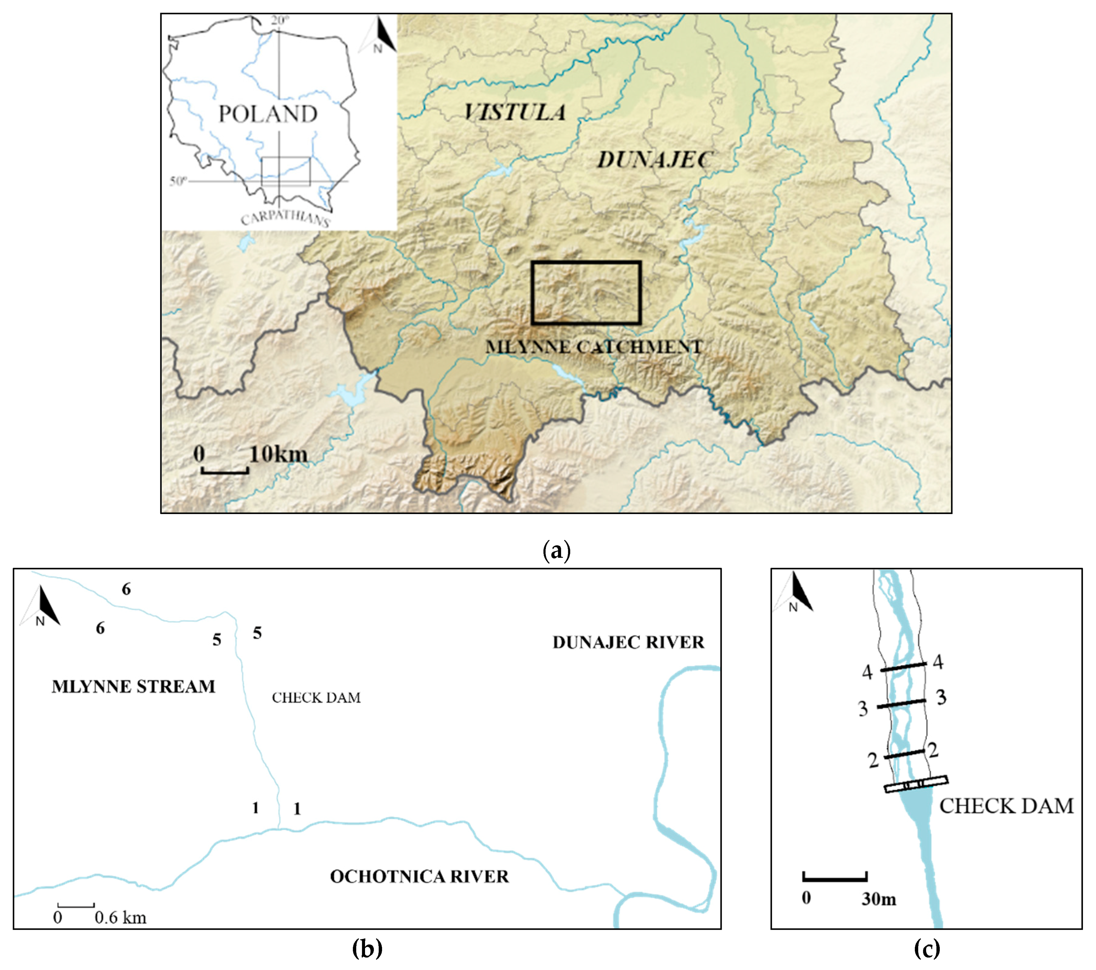
In the middle catchment area there are mainly Tertiary (Paleogene) shales and sub-Magura layer sandstones with the lens of Quaternary slide colluviums. Sparse alluvial settlements are also present in the Mlynne stream valley in the lower part of the catchment area [44]. The measurements were performed at km 0.0 (Mlynne outlet to Ochotnica—495.00 m above sea level) to km 7 + 500 (985.00 m above sea level). The Mlynne stream was divided into six measurement sections (Figure 1); in each section, the following test sections were determined: cross section 1-1 at km 0 + 150 (498.00 m above sea level called ‘bystrotok’); cross sections 2-2, 3-3, 4-4 at km 2 + 800 (at 85.00 m above sea level in the area of the reservoir behind the dam called ‘reservoir’—the sample from section 2-2 was taken from a small, stable sediment deposited just behind the notch of the check dam; the sample from section 3-3 was taken from the river channel in the vicinity of the mainstream stream channel at the check dam water reservoir; sample 4-4 was taken from the reservoir edge, from the inlet to the reservoir); section 5-5 at km 3 + 300 (610.00 m above sea level, the section located in the built-up area in the natural part of the channel called ‘school’); section 6-6 in km 4 + 300 (655.00 m above sea level) in a natural state called ‘Kotelniki’).
Here, we are only presenting bed-load transport calculations for cross sections 2-2 ‘check-dam reservoir,’ cross section 5-5 ‘school’ and 6-6 ‘Kotelniki’. This approach was chosen because we wanted to show the deposition in cross section 2-2 (in the water reservoir formed upstream of the check dam) and the difference in the sediment transport upstream of this place as we are dealing with natural and partly engineered cross sections upstream (5-5 and 6-6). In cross sections 3-3 and 4-4, we have taken sediment transport samples for grain-size reasons to have the average grain size curve for the whole water reservoir upstream of the check dam. Cross section 1-1 is downstream of the check dam and along the whole section (longitudinal profile from the check dam down to the estuary of the Mlynne) both river banks are lined with concrete and artificial boulders which creates a kind of rapid channel. Thus, we do not present bed-load transport values here (sediment is trapped upstream of this section); however, we performed some hydraulics measurements here that are not presented in this paper but which were helpful in understanding the whole regime of the stream; see Figure 1 for details. Exemplary natural as well as modified cross sections of the Młynne Stream are presented in Figure 2 and Figure 3 respectively.
2.2. The Lososina River
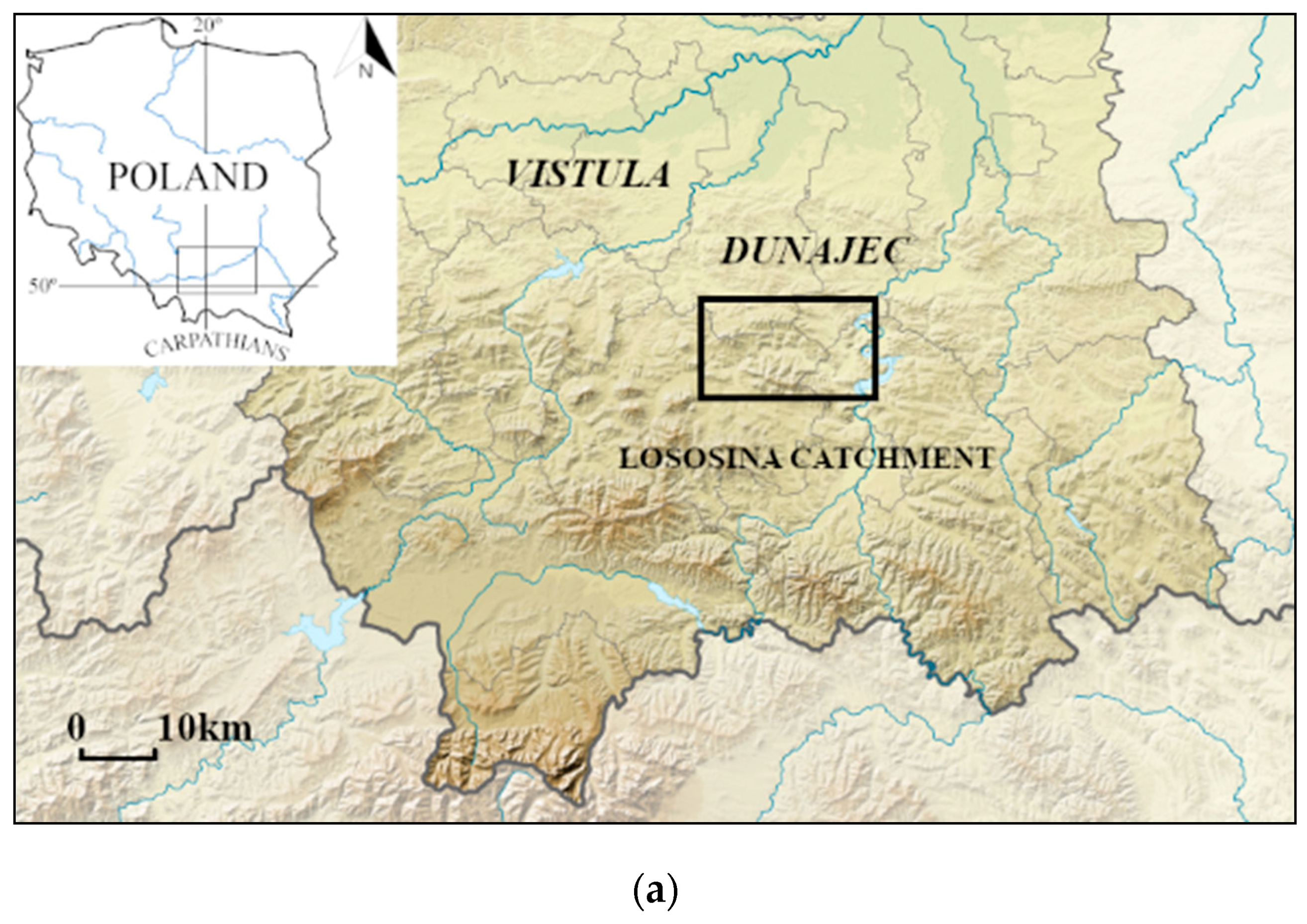
The Lososina River in the Polish part of the Carpathian Mountains (Figure 4) is situated in the Carpathian flysh. The stream is flashy and experiences frequent bed-load movement. Its streambed consists mostly of sandstone and mudstone bed-load pebbles and cobbles forming a framework, the interstices of which are filled by a matrix of finer sediment. Exemplary cross sections of the Lososina River are presented in Figure 5.
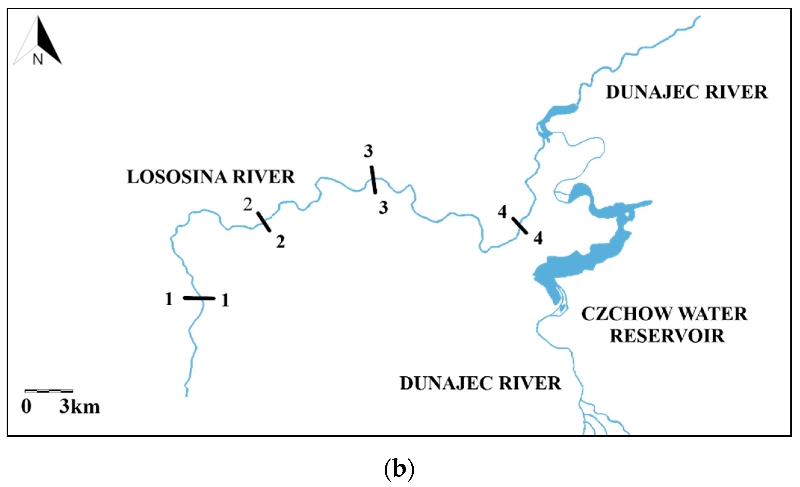
The suspended sediment load is small but contributes to channel morphology—this was taken into consideration during sediment calculations. Many gravel river bed-forms, such as point and middle bars, can be observed within the investigated Lososina River. Most gravel-bed forms can be observed on the riverbanks and within the river channel. After 1975, many river-training works were performed along the Lososina channel to prevent bank erosion and to reduce the channel slope. The river cross sections were trained by building drop-hydraulic structures (for the purpose of slope reduction) and by constructing gabions (stone-baskets along the banks to prevent bank erosion). Those works were aimed at reducing the bed-load transport along the Lososina and stopping its degradation, since the Czchów river reservoir was constructed at the river mouth. The basic hydrological characteristics and grainsize characteristics of the river are presented in Table 2 and Table 3. All numbers refer to the entire river channel between cross sections 1-1 and 4-4.
3. Methods
Bed-load transport for both the Lososina River and the Mlynne stream was calculated using Meyer-Petter Muller [45] formula:
where qi—unit bed-load transport [N s−1]; —water and sediment density (kg m−3); g—acceleration (m s−2); h—water depth (m); I—slope (-); fi—shields shear stress value (-); Δρ = ρr − ρw (kg m−3); di—sediment size (mm); percentage of the sediment fraction within the sediment probe, b—active channel width (m).
According to Michalik [9], the dimensionless shear stress parameter for Polish mountain streams was identified using radioisotope methods and is 0.033—this is taken for all calculations in this paper, although one has to remember that the original Meyer-Petter Muller [45] dimensionless shear stress was 0.047. Field survey and slopes measurements were performed with a TOPCON AT-G7 survey professional level device. The bedload transport value was calculated using the SandCalc 1 software application [46].
In order to understand the hydrological situation of the stream and rivers, some characteristic discharges are usually calculated—this sheds light on how considerable flood events are currently dealt with in river channels. One method used for this purpose is the calculation of T-year floods. As defined by Frost and Clark [47], the T-year flood is a discharge likely to be exceeded once in T-years on average. For example, the 100-year flood is also referred to as the 1% flood, since its annual exceedance probability is 1%. T-year flood values Q for the Mlynne stream estuary and the Lososina stream estuary were calculated using the Punzet method [48,49]—Table 1 and Table 2.
4. Results and Discussion
4.1. The Mlynne Stream
For the sake of clarity, firstly the results of measurements and calculations referring to the bed-load transport are presented in tables and graphs. Table 4 presents bed-load transport results in cross sections 2-2 ‘check-dam reservoir’, cross section 5-5 ‘school’ as well as for 6-6 ‘Kotelniki’.
The bed load transport in all the analysed cross sections of the Mlynne stream is small. Its range is 53.5249 × 10⁻⁵–166.3035 × 10⁻⁵ (kg s−1 m−1), while in other Polish Carpathian streams investigated by Michalik [22], the measured sediment transport where the radioisotope methods were used was, in the Wisłoka Stream: 183.5489 × 10⁻⁵–1488.7857 × 10−5 (kg s−1 m−1), in the Raba Stream: 611.8297 × 10⁻⁵–7138.0135 × 10−5 (kg s−1 m−1) and in the Dunajec River: 3161.1203 × 10−5–3467.0351 × 10−5 (kg s−1 m−1). North American streams with a flow regime similar to that of the Mlynne, such as East Fork in Wyoming, Snake River in Idaho and Mountain Creek in South California, are characterised by higher transport values of: 1019.7162 × 10−5–7138.0135 × 10−5 (kg s−1 m−1), 1019.7162 × 10−5–10197.1621 × 10−5 (kg s−1 m−1) and 50.9858 × 10⁻⁵–1019.7162 × 10−5 (kg s−1 m−1), respectively [11]. Such a small amount of sediment transported might suggest that the necessity of the check dam built in the stream is questionable [36]. It could transpire that rehabilitation works, which could be planned in that catchment take into consideration removing the existing dam with no harm for the sediment budget and in line with stream restoration works advice at present in Polish Carpathians [33,34,35].
4.2. The Lososina River
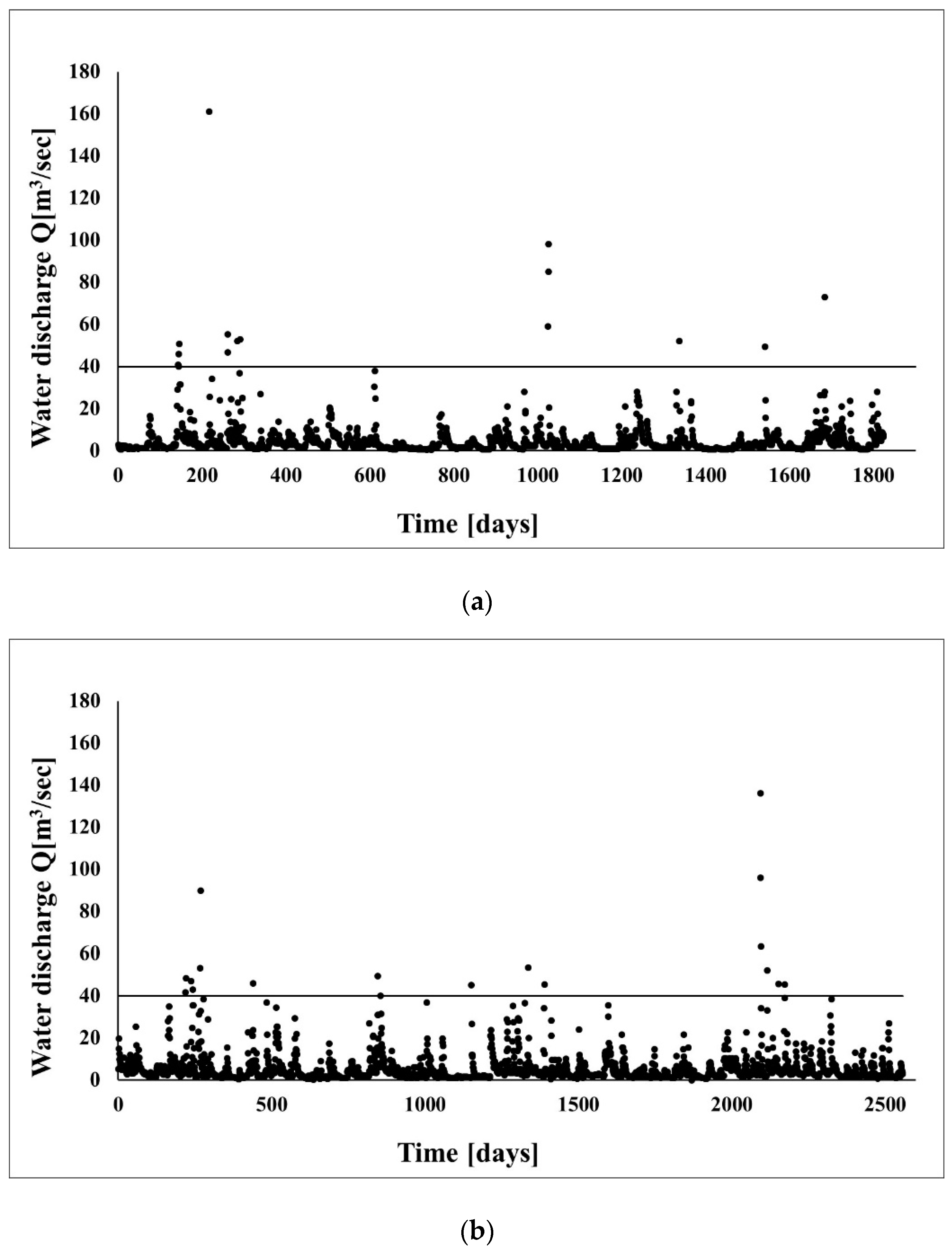
Again, all obtained results are presented in tables and in graphs for the benefit of clarity. Table 5 and Table 6 show the sediment transport data for Lososina before and after river-training works [50,51,52,53,54]. Table 7 presents changes of the unit bed-load transport results for the Lososina River after regulation. Figure 6 presents the hydrological events before and after river-training works at the Lososina used in the TransCalc computer model to calculate the sediment budget along the Lososina.
As can be observed, despite the decreasing of sediment dimensions within the river-trained cross sections, the shear stress values there also decreased; consequently, the unit bed-load volume decreased as well. The most important parameter here, which determines the value of the decreased shear stresses and the bed load, is reduced slope by river training [37,39]. Here, in the 4-4 cross section, the largest decrease of bed-load transport was identified—this was the main aim of the river-training works. Due to river engineering works, the change of the bed-load transport along the Lososina river in the analysed cross sections was as follows: along cross section 1-1, the unit bed load q was larger before the river training at around 1.8121 kg s−1 m−1 (aggradations after river-training works), along cross section 2-2 the unit bed-load q was also larger before the river training of about 16.5302 kg s−1 m−1 (aggradations after river-training works). Along cross section 3-3, the unit bed load q was larger after river training of about 4.5341 kg s−1 m−1 (degradation of the river bed) and finally, along cross section 4-4, the unit bed load q was larger before the river training of about q = 17.9028 kg s−1 m−1. Along the whole river, the unit bed load q was bigger before the river training of about q = 13.3687 kg s−1 m−1, in other words, the river training reduced the bed-load transport of that value. The river training works performed along the Lososina river changed the bed-load transport conditions along its entire length [29,38,55,56].
For both analysed catchments—looking at numbers—one is supposed to find some similarities or dissimilarities and find the problems, which occur in that case in river channels. As we might observed in the Mlynne stream, the bed load transport is low. As we also observed in the field, people from the surrounding terrain who live within the Mlynne catchment remove sediment from the water reservoir upstream of the Mlynne dam after floods and use it for building purposes as well as for strengthening their private land with gravel and clay, depend if they do it on roads or on agriculture fields. Basically, they remove the sediment and in this way, they enlarge the water reservoir volume so it is ready for the sediment from the next flood. This raises the question of whether removing the check dam might be possible because of the low bed-load transport rate. The answer is complicated since downstream of the check dam, there is a road parallel to the engineered stream and if the check dam is removed, sooner or later the road would be covered with sediment. However, one might consider enlarging the river bed downstream of the check dam and when removing it along that area, the Mlynne might to start to be a braided channel again. From a river-management point of view, such a situation is possible but difficult to force upon the local community.
The strengths of the presented approach is that we are gaining knowledge and it may lead us to the identification of easier tools for river management in the future. The weaknesses of the approach are that, although we have increased our understanding of the problems, we cannot force rivers and streams to be braided again because of the local community living in the villages; furthermore, it is difficult to propose the removal of dams as flood protection is traditionally associated with solid hydraulic structures such as dams. Thus, as far as river management is concerned, we need to wait for a really large flood event which could destroy the Mlynne check dam and we might never rebuild it, safe in the knowledge that sediment transport here is low.
In terms of the Lososina, we surprisingly see a good situation of sediment budget after the wisely designed river engineering works. The sediment transported to the Lososina water reservoir is relatively low—this gives the likelihood of the longevity of this water reservoir. In both cases, our study was performed with the specific geology of the Carpathians so one has to bear in mind the limitation of this study to Flysh Mountains. However, the general conclusions are useful for all river management works and might be used for numerical models to improve the performance estimating bed load transport.
5. Conclusions
For both analysed the catchments, the final conclusions are as follows:
- During the floods, the Mlynne Stream transports, in comparison with other mountain streams, there is a lower bed load (53.5249 × 10⁻⁵–166.303 × 10⁻⁵ kg s−1 m−1). This might be connected with the catchment area as well as with the channel slope.
- Since the bed-load transport for the Mlynne is marginal, the need for the existence of the check dam is questionable and in the future it could be possible to deconstruct and remove it. Such a practice would be in line with the rehabilitation works started on the Carpathian streams which are already leading to the reconstruction of braided gravel mountain streams.
- Because of reducing the river slope of the longitudinal profile of the Lososina when it was river trained, the shear stress values decreased. As a consequence of this, the unit bed-load volume decreased. This indicates the importance of the slope of a river channel for sediment movement when managing rivers. It might be reached by, for example, a series of hydraulic structures across the river channel.
- The Lososina river training reduced the bed-load transport by a value of q = 13.3687 kg s−1 m−1. In terms of the water reservoir and its clogging, this is useful information in terms of river management practices because the reservoir is a source of drinking water for the region.
- The study was performed to assist river and mountain stream managers and urban-village planners to understand how important it is to include bed-load transport in designing calculations when dealing with any river channel problems. The next step of such research could be an analysis of the hydrological situation after removing the check dam from the stream and/or introducing a new philosophy of river rehabilitation works to the region where the sediment is low whilst at the same time, giving due consideration to flood protection aims. In all cases, knowledge of the sediment budget is eternally helpful.
Author Contributions
Conceptualization, A.R.-P., B.R.-P., K.P. and P.K.; Methodology, A.R.-P., B.R.-P. and P.K.; Investigation, A.R.-P., B.R.-P. and K.P.; Resources, A.R.-P. and B.R.-P.; Writing-Original Draft Preparation, A.R.-P., B.R.-P., P.K. and K.P.; Writing-Review & Editing, A.R.-P. and P.K.; Visualization, A.R.-P. and P.K.; Supervision, A.R.-P.
Funding
This research was financed by the Ministry of Science and Higher Education of the Republic of Poland: 1. Cracow University of Technology, Faculty of Civil Engineering: L4/106/2018/DS, L4/107/2018/DS and L4/585/2018/DS-M.
Conflicts of Interest
The authors declare no conflict of interest.
References
- Galia, T.; Hradecký, J. Estimation of bedload transport in headwater streams using a numerical model (Moravskoslezké Beskydy Mts, Czech Republic). Acta Univ. Carol. Geogr. 2014, 49, 21–31. [Google Scholar] [CrossRef] [Green Version]
- Church, M.; Hassan, M.A. Size and distance of travel of unconstrained clasts on a streambed. Water Resour. Res. 1992, 28, 299–303. [Google Scholar] [CrossRef]
- Bednarek, A.T. Undamming rivers: A review of the ecological impacts of dam removal. Environ. Manag. 2001, 27, 803–814. [Google Scholar] [CrossRef]
- Stanley, E.H.; Doyle, M.W. Trading off: The ecological effects of dam removal. Front. Ecol. Environ. 2003, 1, 15–22. [Google Scholar] [CrossRef]
- Lane, S.N. Acting, predicting and intervening in a sociohydrological world. Hydrol. Earth Syst. Sci. 2014, 18, 927–952. [Google Scholar] [CrossRef]
- Fox, C.A.; Magilligan, F.J.; Sneddon, C.S. “You kill the dam, you are killing a part of me”: Dam removal and the environmental politics of river restoration. Geoforum 2016, 70, 93–104. [Google Scholar] [CrossRef] [Green Version]
- Magilligan, F.J.; Graber, B.E.; Nislow, K.H.; Chipman, J.W.; Sneddon, C.S.; Fox, C.A. River restoration by dam removal: Enhancing connectivity at watershed scales. Elem. Sci. Anthr. 2016, 4. [Google Scholar] [CrossRef]
- Bellmore, R.J.; Duda, J.J.; Craig, L.S.; Greene, S.L.; Torgersen, C.E.; Collins, M.J.; Vittum, K. Status and trends of dam removal research in United States. Wirel. Water 2017, 4. [Google Scholar] [CrossRef]
- Yang, C.T. Sediment Transport: Theory and Practice; McGraw-Hill: New York, NY, USA, 1996; ISBN 10 0079122655. [Google Scholar]
- Church, M.A.; McLean, D.G.; Wolcot, J.F. River Bed Gravels: Sampling and Analysis. In Sediment Transport in Gravel-Bed Rivers; Throne, C.R., Bathurst, J.C., Hey, R.D., Eds.; John Wiley and Sons: London, UK, 1987; pp. 43–87. [Google Scholar]
- Gomez, B.; Church, M. A Catalogue of Equilibrium Bedload Transport Data for Coarse Sand and Gravel-Bed Channels; University of British Columbia: Vancouver, BC, Canada, 1988. [Google Scholar]
- Carling, P.A. Bedload transport in two gravel-bedded streams. Earth Surf. Process. Landf. 1987, 14, 27–39. [Google Scholar] [CrossRef]
- Mrokowska, M.M.; Rowiński, P.M.; Książek, L.; Strużyński, A.; Wyrębek, M.; Radecki-Pawlik, A. Laboratory studies on bedload transport under unsteady flow conditions. J. Hydrol. Hydromech. 2018, 66, 23–31. [Google Scholar] [CrossRef] [Green Version]
- Dey, S. Fluvial Hydrodynamics: Hydrodynamic and Sediment Transport Phenomena; Springer: Berlin, Germany, 2014; ISBN 978-3-642-19062-9. [Google Scholar]
- Selby, M.J. Earth’s Changing Surface: An Introduction to Geomorphology; Oxford University Press: London, UK, 1985; ISBN 10 9780198232513. [Google Scholar]
- Radecki-Pawlik, A. Pobór żwiru i otoczaków z dna potoków górskich (in Polish). Aura—Ochr. Środowiska 2002, 3, 17–19. [Google Scholar]
- Wyżga, B.; Hajdukiewicz, H.; Radecki-Pawlik, A.; Zawiejska, J. Eksploatacja osadów z koryt rzek górskich—skutki środowiskowe i procedury oceny (in Polish). Gospod. Wodna 2010, 6, 243–249. [Google Scholar]
- Lehotský, M.; Frandofer, M.; Novotný, J.; Rusnák, M.; Szmańda, J.B. Geomorphic/Sedimentary Responses of Rivers to Floods: Case Studies from Slovakia. In Geomorphological Impacts of Extreme Weather. Case Studies from Central and Eastern Europe; Lóczy, D., Ed.; Springer: Dordrecht, The Netherlands, 2013; pp. 37–52. [Google Scholar]
- Lehotský, M.; Kidová, A.; Rusnák, M. Slovensko-anglické názvoslovie morfológie vodných tokov. Geomorphol. Slovaca Et Bohem. 2015, 15, 1–63. Available online: http://www.asg.sav.sk/gfsb/v0151/GSeB_1_2015.pdf (accessed on 2 February 2019).
- Kondolf, G.M. Hungry water: Effects of dams and gravel mining on river channel. Environ. Manag. 1997, 21, 533–551. [Google Scholar] [CrossRef]
- Gladki, H. Discussion of “Determination of Sand Roughness for Fixed Beds”. J. Hydraul. Res. 1975, 13, 221–222. [Google Scholar] [CrossRef]
- Michalik, A. Bed-Load Transport Investigations in Some Polish Carpathians Rivers. Ph.D. Thesis, University of Agricultural in Krakow, Krakow, Poland, 1990. (In Polish). [Google Scholar]
- Radecki-Pawlik, A. Point bars development and sediment structure in the Skawica Creek in Polish Carpathians. International conference on transport and sedimentation of solid particles. Zesz. Nauk. Ar We Wrocławiu 2000, 320, 113–120. [Google Scholar]
- Mikuś, P.; Wyżga, B.; Radecki-Pawlik, A.; Zawiejska, J.; Amirowicz, A.; Oglęcki, P. Environment-friendly reduction of flood risk and infrastructure damage in a mountain river: Case study of the Czarny Dunajec. Geomorphology 2015, 272, 43–54. [Google Scholar] [CrossRef]
- Hajdukiewicz, H.; Wyżga, B.; Amirowicz, A.; Oglęcki, P.; Radecki-Pawlik, A.; Zawiejska, J.; Mikuś, P. Ecological state of a mountain river before and after a large flood: Implications for river status assessment. Sci. Total Environ. 2018, 610–611, 244–257. [Google Scholar] [CrossRef]
- Pagliara, S.; Radecki-Pawlik, A.; Palermo, M.; Plesiński, K. Block ramps in curved rivers: Morphology analysis and prototype data supported design criteria for mild bed slopes. River Res. Appl. 2017, 33, 427–437. [Google Scholar] [CrossRef]
- Pagliara, S.; Radecki-Pawlik, A.; Palermo, N.; Plesiński, K. A Preliminary Study of field scour morphology downstream of block ramps located at river bends. In Proceedings of the 7th IAHR International Symposium on Hydraulic Structures, Aachen, Germany, 15–18 May 2018; Bung, D., Tullis, B., Eds.; Utah State University: Logan, UT, USA, 2018. [Google Scholar]
- Sattar, A.M.A.; Plesiński, K.; Radecki-Pawlik, A.; Gharabaghi, B. Scour depth model for grade-control structures. J. Hydroinform. 2018, 20, 117–133. [Google Scholar] [CrossRef]
- Plesiński, K.; Radecki-Pawlik, A.; Wyżga, B. Sediment Transport Processes Related to the Operation of a Rapid Hydraulic Structure (Boulder Ramp) in a Mountain Stream Channel: A Polish Carpathian Example. In Sediment Metters; Heininger, P., Cullmann, J., Eds.; Springer: Koblenz, Germany, 2015; pp. 39–58. [Google Scholar]
- Plesiński, K.; Pachla, F.; Radecki-Pawlik, A.; Tatara, T.; Radecki-Pawlik, B. Numerical 2D simulation of morphological phenomena of a block ramp in Poniczanka Stream: Polish Carpathians. In Proceedings of the 7th IAHR International Symposium on Hydraulic Structures, Aachen, Germany, 15–18 May 2018; Bung, D., Tullis, B., Eds.; Utah State University: Logan, UT, USA, 2018. [Google Scholar]
- Radecki-Pawlik, A.; Plesiński, K.; Radecki-Pawlik, B.; Kuboń, P.; Manson, R. Hydrodynamic parameters in a flood impacted boulder block ramp: Krzczonówska mountain stream, Polish Carpathians. J. Mt. Sci. 2018, 15, 2335–2346. [Google Scholar] [CrossRef]
- Kałuża, T.; Radecki-Pawlik, A.; Szoszkiewicz, K.; Plesiński, K.; Radecki-Pawlik, B.; Laks, I. Plant basket hydraulic structures (PBHS) as a new river restoration measure. Sci. Total Environ. 2018, 627, 245–255. [Google Scholar] [CrossRef] [PubMed]
- Wyżga, B.; Oglęcki, P.; Radecki-Pawlik, A.; Skalski, T.; Zawiejska, J. Hydromorphological complexity as a driver of the diversity of benthic invertebrate communities in the Czarny Dunajec River, Polish Carpathians. Hydrobiologia 2012, 696, 29–46. [Google Scholar] [CrossRef]
- Wyżga, B.; Oglęcki, P.; Hajdukiewicz, H.; Zawiejska, J.; Radecki-Pawlik, A.; Skalski, T.; Mikuś, P. Interpretation of the invertebrate-based BMWP–PL index in a gravel-bed river: Insight from the Polish Carpathians. Hydrobiologia 2013, 712, 71–88. [Google Scholar] [CrossRef]
- Wyżga, B.; Amirowicz, A.; Oglęcki, P.; Hajdukiewicz, H.; Radecki-Pawlik, A.; Zawiejska, J.; Mikuś, P. Response of fish and benthic invertebrate communities to constrained channel conditions in a mountain river: Case study of the Biała, Polish Carpathians. Limnologica 2014, 46, 58–69. [Google Scholar] [CrossRef]
- Agoramoorthy, G.; Minna, J.H. Small size, big potential: Check dams for sustainable development. Environ. Sci. Policy Sustain. Dev. 2008, 50, 22–35. [Google Scholar] [CrossRef]
- Conesa-Garcia, C.; Lenzi, M.A. Check Dams, Morphological Adjustments and Erosion Control in Torrential Streams; Nova Science Publishers: New York, NY, USA, 2010; ISBN 978-1-61761-749-2. [Google Scholar]
- Renganayaki, P.; Elango, L. A review on managed aquifer recharge by check dams: A case study near Chennai, India. Int. J. Res. Eng. Technol. 2013, 2, 416–423. [Google Scholar] [CrossRef]
- Castillo, C.; Pérez, R.; Gómez, J.A. A conceptual model of check dam hydraulics for gully control: Efficiency, optimal spacing and relation with step-pools. Hydrol. Earth Syst. Sci. 2014, 18, 1705–1721. [Google Scholar] [CrossRef]
- Bucala, A.; Radecki-Pawlik, A. Wpływ regulacji technicznej na zmiany morfologii górskiej potoku: Potok Jamne, Gorce, The influence of hydrotechnical structures on morphological changes of Jamne stream channels in the Gorce Mountains, Polish Carpathians. Acta Sci. Pol. Form. Circumiectus 2011, 10, 3–16. [Google Scholar]
- Horton, R.E. Erosional development of streams and their drainage basins; hydrophysical approach to quantitative morphology. Bull. Geol. Soc. Am. 1945, 56, 275–370. [Google Scholar] [CrossRef]
- Kajetanowicz, Z. Untersuchungsmethoden der Sinkstoffbewegung in den Flüssen Südpolens. In Proceedings of the VI Baltische Hydrologische Konferenz, Berlin, Germany, August 1938; Volume 19D, p. 19. [Google Scholar]
- Chalov, S.; Golosov, V.; Tsyplenkov, A.; Theuring, P.; Zakerinejad, R.; Märker, M.; Samokhin, M.A. Toolbox for sediment budget research in small catchments. Geogr. Environ. Sustain. 2017, 10, 43–68. [Google Scholar] [CrossRef]
- Radecki-Pawlik, A.; Bucała, A.; Plesiński, K.; Oglęcki, P. Ecohydrological conditions in two catchments in the Gorce Mountains: Jaszcze and Jamne streams—Western Polish Carpathians. Ecohydrol. Hydrobiol. 2014, 14, 229–242. [Google Scholar] [CrossRef]
- Meyer-Peter, E.; Mueller, R. Formulas for bedload transport. In Proceedings of the II Congress IAHR 1948, Stockholm, Sweden, 7 June 1948; pp. 39–64. [Google Scholar]
- Wallingford University the SandCalc1_1 Software; Wallingford University: Wallingford, UK, 1996.
- Frost, J.; Clarke, R.T. Estimating the T-tear flood by the extension of records of partial duration series. Hydrol. Sci. J. 1972, 17, 209–217. [Google Scholar] [CrossRef]
- Punzet, J. Empiryczny system ocen charakterystycznych przepływów rzek i potoków w karpackiej części dorzecza Wisły (in Polish). Wiadomości Inst. Meteorol. I Gospod. Wodnej 1981, 7, 31–40. [Google Scholar]
- Radecki-Pawlik, A. Woda-v. 2. 0—A simple hydrological computer model to calculate the T-year flood. Hydrological processes in the catchment. Cracow University of Technology. In Proceedings of the International Conference 1995, Cracow, Poland, 26–28 October 1995. [Google Scholar]
- Florkowski, J.; Adamek, D. Wielozadaniowy zbiornik retencyjny Młynne na rz. Łososinie (in Polish), the multi-role storage reservoir Mlynne on the river Lososina. Gospod. Wodna 2004, 5, 197–203. [Google Scholar]
- HYDROPROJEKT Designing Office. Studium do Założeń Kompleksowych Gospodarki Wodnej w Dorzeczu Łososiny; CBS i PBW Hydroprojekt: Kraków, Poland, 1953. (In Polish) [Google Scholar]
- HYDROPROJEKT Designing Office. Założenia Gospodarki Wodnej Dorzecza Dunajca; CUGW, CBS i PBW Hydroprojekt: Kraków, Poland, 1961. (In Polish) [Google Scholar]
- Kaszowski, L.; Kotarba, A. Wpływ Katastrofalnych Wezbrań na Przebieg Procesów Fluwialnych; Prace Geograficzne Instytutu Geografii PAN: Warszawa, Poland, 1970. (In Polish) [Google Scholar]
- Gorczyca, E. Przekształcanie Stoków Fliszowych Przez Procesy Masowe Podczas Katastrofalnych Opadów (Dorzecze Łososiny); Wydawnictwo Uniwersytetu Jagiellońskiego: Cracow, Poland, 2005; ISBN 83-233-1957-X. (In Polish) [Google Scholar]
- Shvidchenko, A.B.; Kopaliani, Z.D. Hydraulic modeling of bed load transport in gravel-bed Laba River. J. Hydraul. Eng. 1998, 124, 778–785. [Google Scholar] [CrossRef]
- Lisle, T.E.; Nelson, J.M.; Pitlick, J.; Madej, M.A.; Barket, B.L. Variability of bed mobility in natural, gravel-bed channels and adjustments to sediment load at local and reach scales. Water Resour. Res. 2000, 36, 3743–3755. [Google Scholar] [CrossRef] [Green Version]
Figure 1.
Location of the Mlynne Stream catchment (a); the chosen research cross sections and research reach (b); check dam cross sections details (c).
Figure 1.
Location of the Mlynne Stream catchment (a); the chosen research cross sections and research reach (b); check dam cross sections details (c).

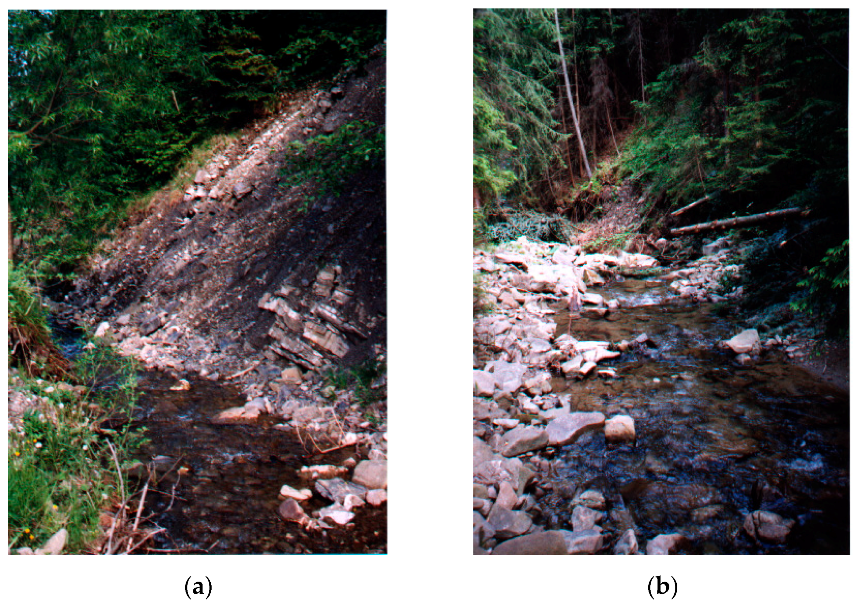
Figure 2.
Mlynne stream—natural cross sections. (a) upper part not engineered; (b) source part.

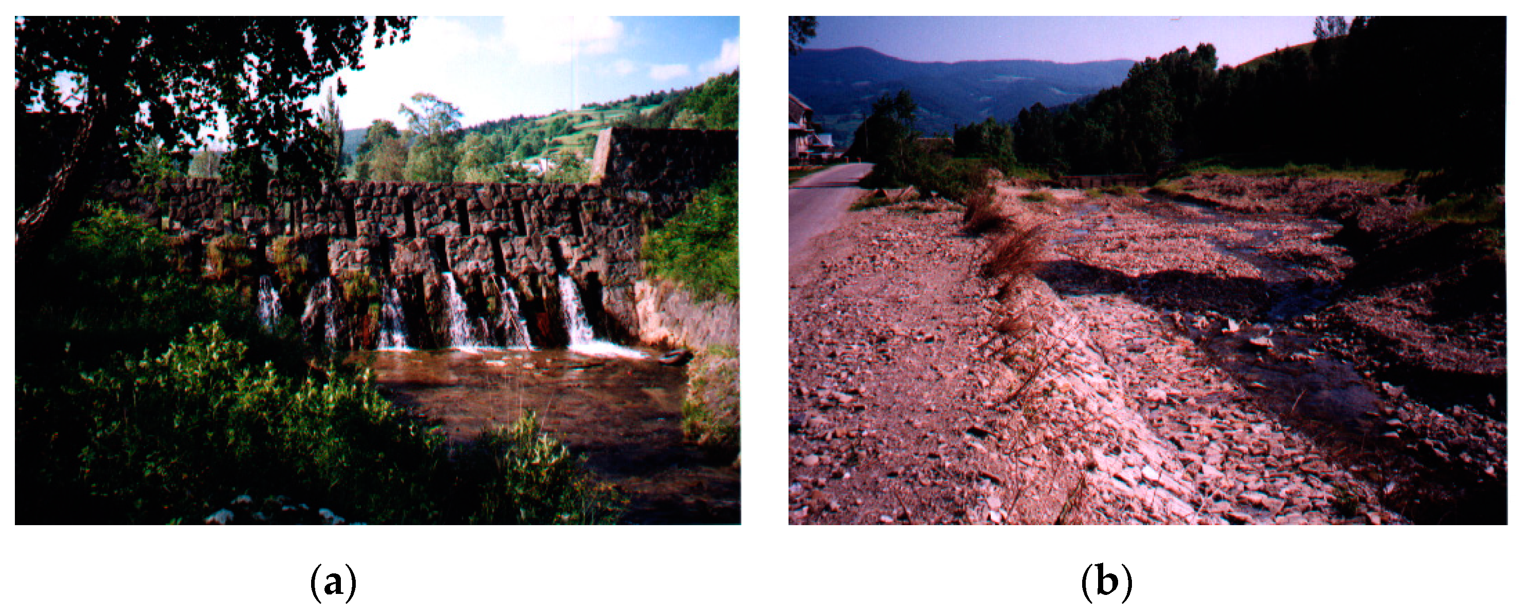
Figure 3.
Mlynne stream—cross sections modified with check dam and water reservoir upstream of the check dam. (a) check-dam; (b) check-dam reservoir with coarse sediment; (c) down stream of a check-dam; (d) fine sediment in a check-dam reservoir.
Figure 3.
Mlynne stream—cross sections modified with check dam and water reservoir upstream of the check dam. (a) check-dam; (b) check-dam reservoir with coarse sediment; (c) down stream of a check-dam; (d) fine sediment in a check-dam reservoir.


Figure 4.
Catchment study region of the Lososina River (a) with a detailed sketch of the research reach (b).
Figure 4.
Catchment study region of the Lososina River (a) with a detailed sketch of the research reach (b).


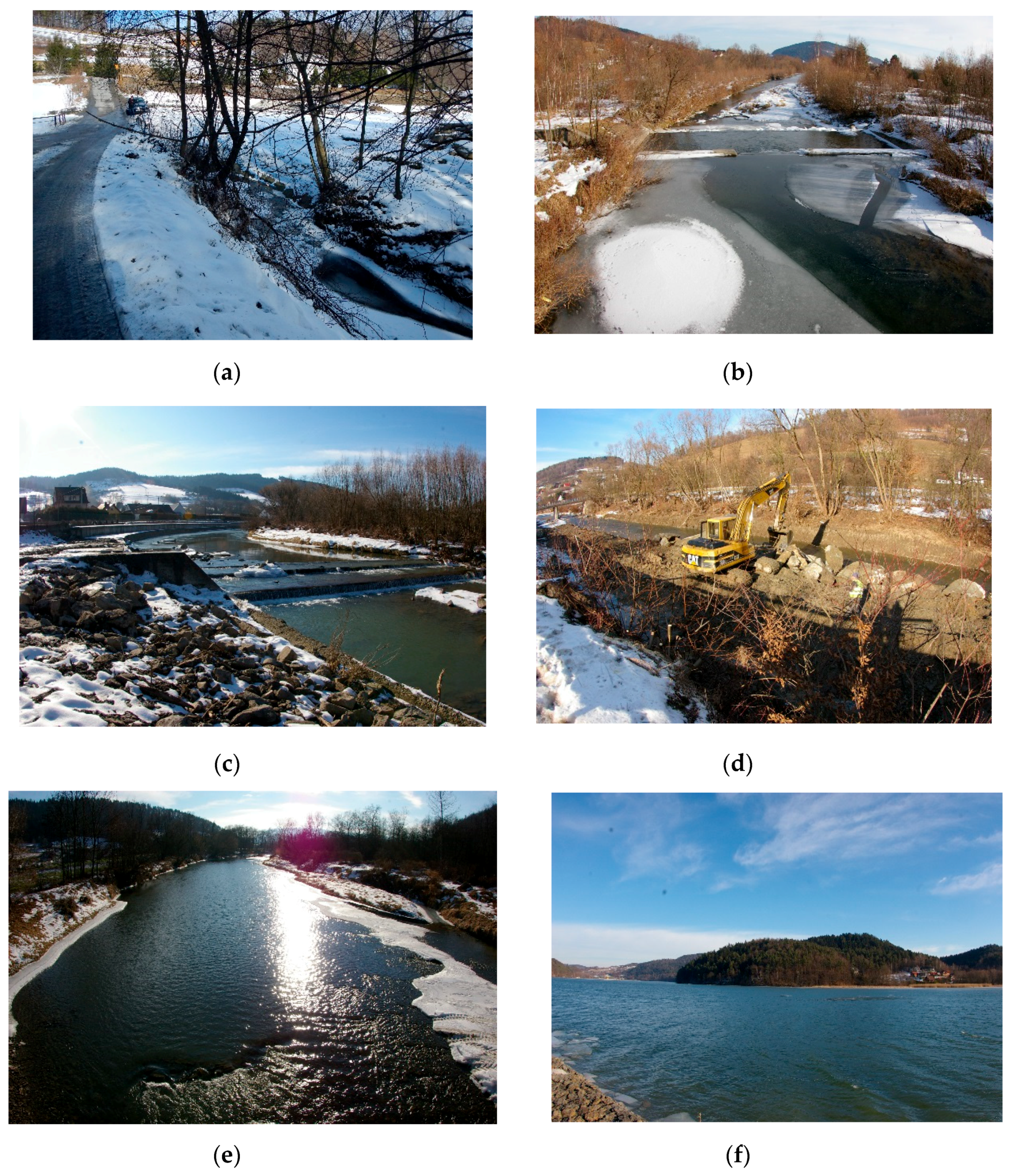
Figure 5.
The Lososina River—different cross sections along the river reach. (a) source part in Dobra; (b) engineered part in Podplomien; (c) engineered part in Tymbark; (d) river training works in Laskowa; (e) natural part in Lososina; (f) water reservoir Czchow.
Figure 5.
The Lososina River—different cross sections along the river reach. (a) source part in Dobra; (b) engineered part in Podplomien; (c) engineered part in Tymbark; (d) river training works in Laskowa; (e) natural part in Lososina; (f) water reservoir Czchow.

Figure 6.
Water discharge levels for the Lososina river with the threshold line (the beginning of motion for the sediment) above which the bed-load transport was calculated before (a) and after (b) the river-training works performed in 1975. The horizontal lines are showing the discharge value above which bedload transport occurs.


Table 1.
Physical characteristics of investigated sites the Mlynne Stream.
| Variables | The Mlynne Stream |
|---|---|
| precipitation (mm) | 850 |
| catchment area (km2) | 7.3 |
| max. catchment area altitude (m a.s.l.) | 985.00 |
| min. catchment area altitude (m a.s.l.) | 495.00 |
| channel gradient (average within study area) (-) | 0.022 |
| max. stream length (km) | 7.50 |
| T-year flood Q50% (m3·s−1) | 7.70 |
| T-year flood Q5% (m3·s−1) | 40.4 |
| d16 (mm) | 7 |
| d50 (mm) | 39 |
| d84 (mm) | 94 |
| d90 (mm) | 102 |
Table 2.
Physical characteristics of investigated sites—the Lososina River.
| Variables | The Lososina River |
|---|---|
| precipitation (mm) | 896 |
| catchment area (km2) | 410 |
| max. catchment area altitude (m a.s.l.) | 760.00 |
| min. catchment area altitude (m a.s.l.) | 241.00 |
| channel gradient (average within study area) (-) | 0.011 |
| max. stream length L (km) | 49.00 |
| discharge Q50% (m3 s−1)/flood Q50% | 48.63 |
| discharge Q5% (m3 s−1)/flood Q3% | 196.41 |
Table 3.
Characteristic grain size for the Lososina River before and after river-training works.
| Sampled Cross Section | Before River-Training Works | After River-Training Works | ||||||
|---|---|---|---|---|---|---|---|---|
| Sediment Diameter (mm) | Sediment Diameter (mm) | |||||||
| d16 | d50 | d84 | d90 | d16 | d50 | d84 | d90 | |
| 1-1 | 7 | 28 | 83 | 88 | 7 | 30 | 85 | 90 |
| 2-2 | 10 | 30 | 70 | 76 | 6 | 22 | 65 | 70 |
| 3-3 | 12 | 40 | 90 | 95 | 10 | 35 | 88 | 90 |
| 4-4 | 10 | 30 | 58 | 67 | 11 | 22 | 50 | 65 |
Table 4.
Unit bed-load transport measured in sampling cross sections: 2-2 ‘check-dam reservoir’; 5-5 ‘school’ and 6-6 ‘Kotelniki’.
Table 4.
Unit bed-load transport measured in sampling cross sections: 2-2 ‘check-dam reservoir’; 5-5 ‘school’ and 6-6 ‘Kotelniki’.
| Unit Bedload Transport (kg s−1 m−1) | |||||
|---|---|---|---|---|---|
| Water Depth h (m) | Sampling Cross Section 2-2 | Depth h (m) | Sampling Cross Section 5-5 | Depth h(m) | Sampling Cross Section 6-6 |
| 0.10 | 0.643 | 0.10 | no bed-load transport | 0.10 | no bed-load transport |
| 0.30 | 1.338 | 0.30 | no bed-load transport | 0.30 | no bed-load transport |
| 0.50 | 1.880 | 0.50 | 20.7308 × 10⁻⁵ | 0.50 | 7.4031 × 10⁻⁵ |
| 0.70 | 2.303 | 0.70 | 48.1816 × 10⁻⁵ | 0.70 | 2.6798 × 10⁻⁵ |
| 0.90 | 2.028 | 0.90 | 161.1152 × 10⁻⁵ | 0.90 | 54.4528 × 10⁻⁵ |
| 1.20 | 2.878 | 1.20 | 165.7039 × 10⁻⁵ | 1.20 | 101.7977 × 10⁻⁵ |
| Total | 53.5249 × 10⁻⁵ | Total | 395.7315 × 10⁻⁵ | Total | 166.3035 × 10⁻⁵ |
Table 5.
Unit bed-load transport at the Lososina River—prior to the training works.
| Water Depth h (m) | Sampling Cross Section 1-1 | Sampling Cross Section 2-2 | Sampling Cross Section 3-3 | Sampling Cross Section 4-4 | ||||
|---|---|---|---|---|---|---|---|---|
| d50 = 28 (mm) | d50 = 28 (mm) | d50 = 28 (mm) | d50 = 28 (mm) | |||||
| Shear Stress τ (N m−2) | Transport (kg s−1 m−1) | Shear Stress τ (N m−2) | Transport (kg s−1 m−1) | Shear Stress τ (N m−2) | Transport (kg s−1 m−1) | Shear Stress τ (N m−2) | Transport (kg s−1 m−1) | |
| 0.6 | no bed-load transport | no bed-load transport | no bed-load transport | no bed-load transport | ||||
| 0.7 | 21.39 | 0.0112 | ||||||
| 0.8 | 23.24 | 0.1439 | ||||||
| 0.9 | 28.07 | 0.7892 | ||||||
| 1.0 | 29.28 | 0.9990 | ||||||
| 1.1 | 32.38 | 1.6059 | ||||||
| 1.2 | 34.67 | 2.1094 | ||||||
| 1.3 | 43.76 | 4.5236 | 25.78 | 0.2520 | ||||
| 1.4 | max. depth in cross section 1. 3 (m) | 28.24 | 0.5793 | 33.47 | 0.2764 | 22.65 | 0.0037 | |
| 1.5 | 32.28 | 1.2797 | 39.36 | 1.2034 | 27.42 | 0.4600 | ||
| 1.6 | 35.60 | 1.9796 | 49.38 | 3.5642 | 32.57 | 1.3383 | ||
| 1.7 | 41.33 | 3.4106 | 52.34 | 4.4070 | 38.09 | 2.5705 | ||
| 1.8 | 43.98 | 4.1499 | 55.38 | 5.3318 | 43.98 | 4.1499 | ||
| 1.9 | 50.23 | 6.0818 | 58.49 | 6.3414 | 50.23 | 6.0818 | ||
| 2.0 | 53.09 | 7.0490 | 61.69 | 7.4332 | 53.09 | 7.0490 | ||
Table 6.
Unit bed-load transport at the Lososina River—after the training works.
| Water Depth h (m) | Sampling Cross Section 1-1 | Sampling Cross Section 2-2 | Sampling Cross Section 3-3 | Sampling Cross Section 4-4 | ||||
|---|---|---|---|---|---|---|---|---|
| d50 = 28 (mm) | d50 = 28 (mm) | d50 = 28 (mm) | d50 = 28 (mm) | |||||
| Shear Stress τ (N m−2) | Transport (kg s−1 m−1) | Shear Stress τ (N m−2) | Transport (kg s−1 m−1) | Shear Stress τ (N m−2) | Transport (kg s−1 m−1) | Shear Stress τ (N m−2) | Transport (kg s−1 m−1) | |
| 0.8 | no bed-load transport | no bed-load transport | no bed-load transport | no bed-load transport | ||||
| 0.9 | 22.85 | 0.0103 | ||||||
| 1.0 | 27.78 | 0.5177 | 28.43 | 0.1389 | ||||
| 1.1 | 33.03 | 1.4284 | 30.68 | 0.3956 | ||||
| 1.2 | 35.36 | 1.9266 | 31.77 | 0.5475 | ||||
| 1.3 | 44.63 | 4.3380 | 32.28 | 0.6246 | 17.36 | 0.0352 | ||
| 1.4 | max. depth in cross section 1. 3 (m) | 33.46 | 0.8136 | 18.27 | 0.1010 | |||
| 1.5 | 44.77 | 3.3258 | 19.21 | 0.1892 | ||||
| 1.6 | 17.80 | 0.0639 | 47.54 | 4.0969 | 19.95 | 0.2708 | ||
| 1.7 | 24.21 | 0.8960 | 50.38 | 4.9422 | 20.94 | 0.3935 | ||
| 1.8 | 26.26 | 1.2720 | 53.31 | 5.8671 | 21.95 | 0.5340 | ||
| 1.9 | 28.38 | 1.7092 | 56.30 | 6.8662 | 25.29 | 1.0897 | ||
| 2.0 | 30.57 | 2.1995 | 59.38 | 7.9420 | 25.72 | 1.1708 | ||
Table 7.
Budget of the unit bed-load transport—the Lososina River.
| Unit Bed−Load Transport (kg s−1 m−1) | |||||||
|---|---|---|---|---|---|---|---|
| Depth h (m) | Sampling Cross Section 1-1 | Depthh (m) | Sampling Cross Section 2-2 | Depthh (m) | Sampling Cross Section 3-3 | Depthh (m) | Sampling Cross Section 4-4 |
| 0.9 | 0.7788 | 1.6 | 1.9157 | 1.5 | −2.1200 | 1.4 | −0.0973 |
| 1.0 | 0.4873 | 1.7 | 2.5146 | 1.6 | −0.3100 | 1.5 | 0.2708 |
| 1.1 | 0.1776 | 1.8 | 2.8779 | 1.7 | −0.5353 | 1.6 | 1.0674 |
| 1.2 | 0.1829 | 1.9 | 4.3725 | 1.8 | −0.5353 | 1.7 | 2.1770 |
| 1.3 | 0.1855 | 2.0 | 4.8495 | 1.9 | −0.5247 | 1.8 | 3.6146 |
| - | - | - | - | 2.0 | −0.5088 | 1.9 | 4.9921 |
| - | - | - | - | - | - | 2.0 | 5.8782 |
| Total | 1.8121 | Total | 16.5302 | Total | −4.5341 | Total | 17.9028 |
© 2019 by the authors. Licensee MDPI, Basel, Switzerland. This article is an open access article distributed under the terms and conditions of the Creative Commons Attribution (CC BY) license (http://creativecommons.org/licenses/by/4.0/).
Share and Cite
MDPI and ACS Style
Radecki-Pawlik, A.; Kuboń, P.; Radecki-Pawlik, B.; Plesiński, K. Bed-Load Transport in Two Different-Sized Mountain Catchments: Mlynne and Lososina Streams, Polish Carpathians. Water 2019, 11, 272. https://doi.org/10.3390/w11020272
AMA Style
Radecki-Pawlik A, Kuboń P, Radecki-Pawlik B, Plesiński K. Bed-Load Transport in Two Different-Sized Mountain Catchments: Mlynne and Lososina Streams, Polish Carpathians. Water. 2019; 11(2):272. https://doi.org/10.3390/w11020272
Chicago/Turabian StyleRadecki-Pawlik, Artur, Piotr Kuboń, Bartosz Radecki-Pawlik, and Karol Plesiński. 2019. "Bed-Load Transport in Two Different-Sized Mountain Catchments: Mlynne and Lososina Streams, Polish Carpathians" Water 11, no. 2: 272. https://doi.org/10.3390/w11020272
Note that from the first issue of 2016, this journal uses article numbers instead of page numbers. See further details here.