Analysis of Irrigation Canal System Characteristics in Heilongjiang Province and the Influence on Irrigation Water Use Efficiency


1
School of Water Conservancy and Civil Engineering, Northeast Agricultural University, Harbin 150030, China
2
The Key Lab of High Efficient Utilization in Agricultural Water Resources of Ministry of Agriculture of China, Harbin 150030, China
3
Heilongjiang Provincial Key Laboratory of Water Resources and Water Conservancy Engineering in Cold Region, Northeast Agricultural University, Harbin 150030, China
*
Author to whom correspondence should be addressed.
Water 2018, 10(8), 1101; https://doi.org/10.3390/w10081101
Submission received: 24 July 2018
/
Revised: 16 August 2018
/
Accepted: 16 August 2018
/
Published: 18 August 2018
(This article belongs to the Section Water Resources Management, Policy and Governance)
Abstract
:Irrigation water use efficiency is a primary evaluation index that links economic production development with the efficient use of water resources. Canal water conveyance is an important part of irrigation, and the distribution characteristics of canal systems have an important influence on irrigation water use efficiency. In this paper, 75 irrigated districts in Heilongjiang Province in 2015 were selected as the study objects. The main, branch, lateral, and sublateral canals were graded into first-, second-, third-, and fourth-order classes, respectively. The irrigation districts were divided into three classes, that is, four-order, three-order, and two-order, according to the canal orders that the irrigation districts contained. The canal system framework was described by Horton’s law. The fractal dimension of the canal system was calculated based on the bifurcation ratio and length ratio of the canals. The relationships between fractal dimensions and irrigation water use efficiency were evaluated. The results showed that the irrigation water use efficiency of the four-order and three-order irrigation districts initially increased and then decreased with increases in the fractal dimension (D). In the irrigation districts, an irrigation water use efficiency of more than 10 × 103 hm2 and less than 0.67 × 10³ hm2 was proportional to the increase in the fractal dimension, whereas the opposite result was found for districts with (0.67–10) × 103 hm2. The irrigation water use efficiency of the four-order and two-order irrigation districts with less than 3.3 × 10³ hm2 had the greatest potential to increase the water use efficiency. Therefore, canal system reconstruction suggestions for different irrigation districts were provided. The results have important theoretical significance and practical value for the improvement of irrigation construction and the promotion of irrigation water efficiency planning.
1. Introduction
The internationally accepted term for the effective utilization of irrigation water is “irrigation efficiency” and is divided into the following three parts by the International Commission on Irrigation and Drainage (ICID); namely, water delivery efficiency, water distribution efficiency, and field irrigation efficiency [1]. In China, the term “irrigation water use efficiency” (IWUE) is commonly used and is defined by the Chinese “technical terminology for rural water conservancy” as the ratio between the amount of water that can be used by the crop and the total amount of water diverted from canals [2]. This concept is similar to water delivery efficiency [3]. The factors affecting the efficiency of irrigation water use are complex and diverse, and research on various influencing factors has achieved many results [4,5,6,7]. A canal is the waterway that connect irrigation water sources and irrigated land. As a represented static factor, canal characteristics play a fundamental role in the IWUE, and the IWUE varies greatly under different conditions [8]. The canal is the main project to undertake the function of irrigation water use and water distribution. The engineering status and distribution characteristics of canals have direct effects on the IWUE in irrigation districts. Many scholars have also realized the importance of channel research [9,10,11,12,13,14].
However, previous canal studies have focused only on canal lining methods and seepage prevention materials; thus, the influence of the structure of the canal system on the water distribution and conveyance has been neglected. Few studies have investigated the correlation between the complexity of canal networks and IWUE. Irrigation canal systems similar to the artificial road, water channel, pipeline, and other network systems are based on the laws of nature, thus giving full play to subjective initiatives. These systems have many similarities with fractal systems (such as water systems) formed by self-organization in nature. They are objective reflections of the laws of nature and the characteristics of fractal systems. The principle of fractals has many applications in water system research [15,16,17]. Among several methods for analyzing fractals, Horton’s laws have been widely applied, and they consist of several numerical ratios and represent a theoretical method for analyzing the characteristics of river network geometry. Considerable research has been conducted in this field, and a number of results have been obtained [18,19,20]. Kim and Jung [21] presented an analysis of the geometric properties of drainage structures using Horton’s law and determined a valid range in which scale invariance of the channel network remains the same. Moussa [22] proposed new indices independent of threshold area that have similar properties to the Horton–Strahler ratios. Mantilla et al. [23] extended generalized Horton’s laws to test embedding algorithms for topological river networks. Later, many scholars applied Horton’s law to other fields. Zhang et al. [24] established a model based on the correlation of flooding frequency and fractal dimension to investigate the effect of rapid urbanization-induced changes in river geomorphology on the local flood frequency in Hangzhou. Yang et al. [25] analyzed river network system changes and their impacts on storage and flood control capacity under rapid urbanization. Stankiewicz and Wit [26] reported the correlation between Horton’s ratio of stream numbers and the mean source stream slope.
Heilongjiang Province is located on the Songnen Plain and the Sanjiang Plain. As a large agricultural province, Heilongjiang is an important grain commodity base in China. The changes in the four seasons in Heilongjiang Province are noticeable, and winters are cold. Research on irrigation districts in Heilongjiang Province is of great significance for the study of high-latitude irrigation areas. For many years, the IWUE in this province has been lower than the national average [27,28]. Increasing the efficiency of irrigation water requires the joint development of irrigation districts across the whole province. Therefore, variations in the IWUE in different irrigation districts of Heilongjiang Province must analyzed, and the main constraints to achieving equilibrium growth of the IWUE must be determined. Previous studies on the factors that influence the IWUE in Heilongjiang Province did not consider the effects of canal system complexity. Therefore, this paper took Heilongjiang Province, an important commodity grain production base in China, as the research object. We used the Horton fractal method to analyze the complexity of the canal system in the irrigation districts. On this basis, IWUE variations in various irrigation districts in Heilongjiang Province were summarized in terms of fractal dimension, and the reasons for the variations were analyzed. Then, we calculated the potential to increase the IWUE after canal transformation in different irrigation districts and provided canal system reconstruction suggestions for different irrigation districts. This step will provide a theoretical basis for improving the efficiency of agricultural water utilization and improving irrigation construction in Heilongjiang Province.
2. Materials and Methods
2.1. Study Area
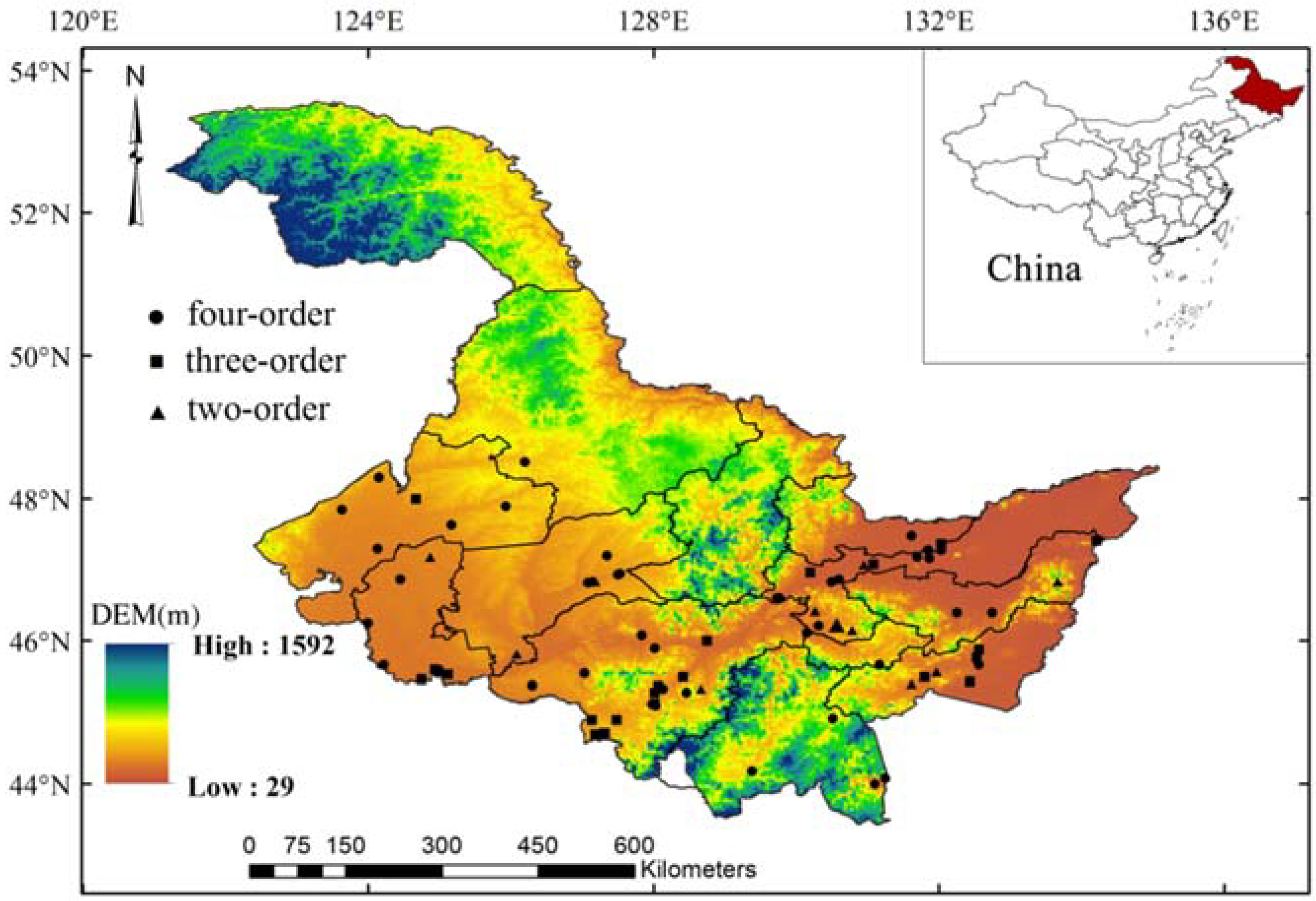
The study region, Heilongjiang Province, is located in the northeastern part of China between 121°13′–135°06′ E and 43°26′′–53°34′′ N (Figure 1). The topography of this province is characterized by mountains to the north and east that surround the central great plains. The Songnen Plain to the west and the Sanjiang Plain to the northeast are two of the most important regions of agricultural production in China [29]. The climate ranges from humid to semi-humid, and the average precipitation is approximately 540 mm/year, with the growing season precipitation (May–September) accounting for 80–90% of the yearly rainfall. Heilongjiang Province has 15.94 million hectares of arable land, which ranks second highest in China, and the per capita arable land is three times the country average. The food crops grown here are mainly rice, maize, and soybean, which cover more than 90% of the total sown area. Water is essential for agricultural development and food production. Although China’s water resources are abundant, the per capita water availability is only 2039.2 m3, which is less than a quarter of the global level, and the per capita water availability in Heilongjiang Province is 2129.8 m3, which is near the average for the country. The water demands of grain production seriously restrict the distribution of water resources to other industries in Heilongjiang Province.
2.2. Data and Methods
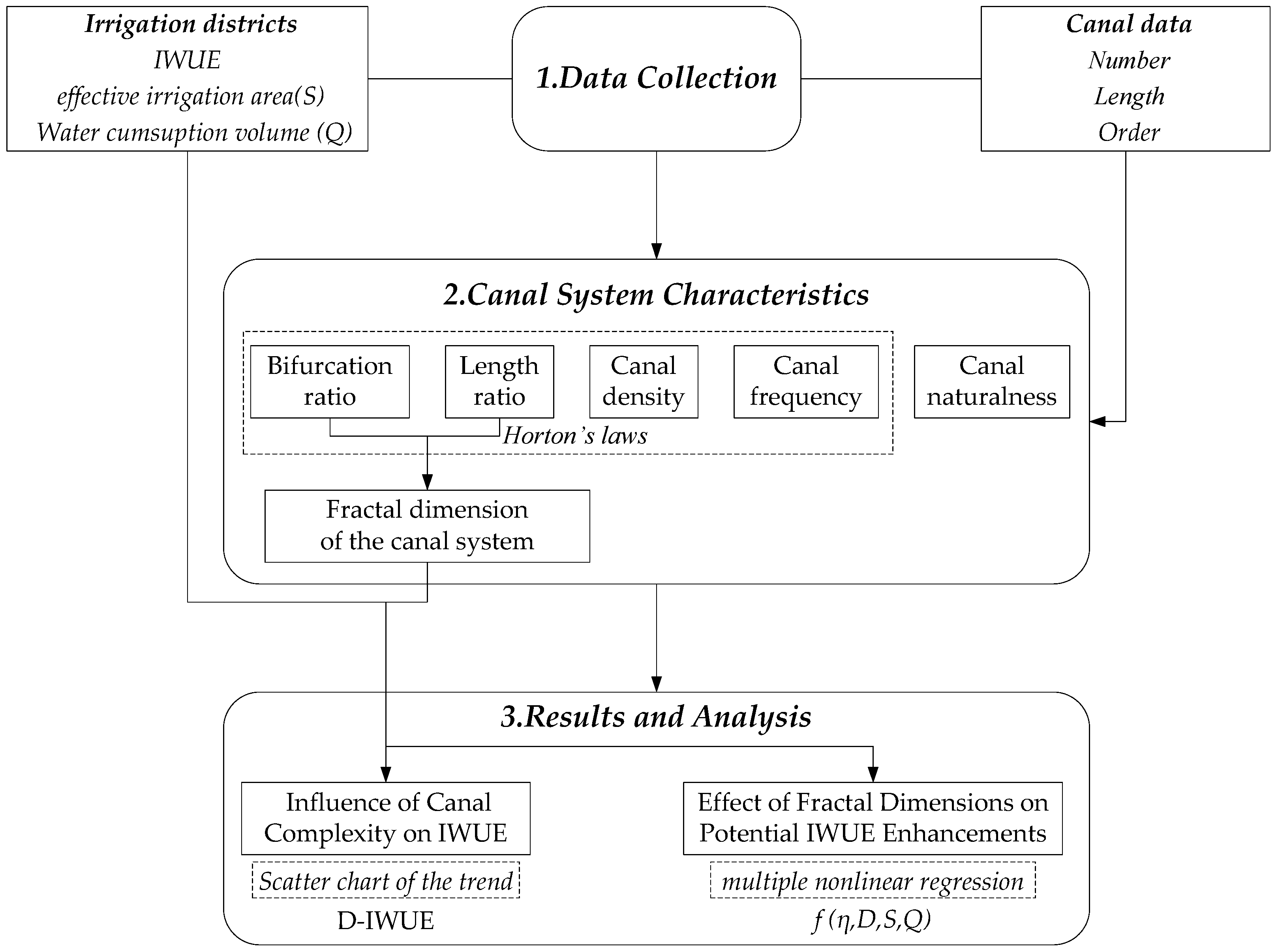
In this study, data on the irrigation districts in 2015 were obtained via investigations, the collection of a summary of previous calculation results for the effective utilization coefficient of irrigation water in the Heilongjiang irrigation area, and information from the Heilongjiang irrigation information website. According to the water diversion water delivery sequence, the canal system is divided into the main canal, branch canal, lateral canal, and sublateral canal in China. Referring to Horton’s law for river system order classification [30], the main canal, branch canal, lateral canal, and sublateral canal were converted to first-, second-, third- and, fourth-order classes, respectively. The annual data of 115 sample irrigation districts in Heilongjiang Province in 2015 were used to statistically classify the canal structure. Based on the canal order, 115 irrigation districts were initially divided into five categories: four, three, two, one, and none. To ensure the uniqueness and reliability of the statistical data, we first removed well-irrigation districts with areas of only a few to several tens of hectares. We also removed irrigation districts that presented unconventional canal systems (single structures, one-order water conveyance canals) because of the influence of the small area or close proximity to the water source. Three types of irrigation districts were retained, and factors such as the location, the irrigation scale, the water diversion method, the irrigation engineering availability, and the canal structure were compared, and then each category was further screened. The screening principle was as follows: the number of channels per level was higher than that of the upper level; the difference between the actual irrigation area and the effective irrigation area was small; the spatial distribution of samples was uniform; the rate of irrigation engineering availability was over 50%, and the irrigation water diversion method was artesian diversion. Screening was performed to minimize the interference of other factors on the results, and 75 large-, medium-, and small-sized sample irrigation districts were retained for analysis. To verify the reliability of the data, the stratified sampling method [31,32] was used to investigate each sorting of the screening irrigation districts. After performing the stratified sampling survey, the collected data were generally consistent with the actual situation of the irrigation district; thus, the method had strong reliability. A well-known homogeneity test (standard normal homogeneity test (SNHT)) was also applied to verify the homogeneity of the IWUE samples [33,34]. The SNHT value was within the standard range of the homogeneity test. The diagram of methodology is illustrated in Figure 2.
The spatial distribution is shown in Figure 1. Irrigation districts with all orders of channels are four-order irrigation districts. The irrigation districts with three of these orders are three-order irrigation districts, and those with only two orders of irrigation districts are two-order irrigation districts.
2.2.1. Method for Calculating the IWUE
In China, the “head to tail” test method is commonly used to measure the IWUE, and it is shown in Equation (1). The “head to tail” method was used to measure the net irrigation water use and gross irrigation water use. The “head” test was used to measure the amount of irrigation water diverted from the water source, and the “tail” test was used to measure the water that reaches fields.
where Vf is the volume of water that reaches the farm or field, in m3; and Vt is the volume of water diverted from the source, in m3.
2.2.2. Observed Regularities in Stream Network Structure
Horton’s “law of stream numbers” states that Nω, the number of streams of order ω, decreases geometrically with the stream order as follows [30]:
where Ω is the order of the network’s main stream and Rb is the “bifurcation ratio”. Horton’s “law of stream lengths” holds that Lω, the mean length of streams of each order, increases geometrically with stream order as follows:
where L1 is the mean length of the first-order tributaries and RL is termed the “length ratio”. The antilog of the absolute value of the straight slope obtained on the ω-lgNω and ω-lgLω coordinates (ω is abscissa) denotes the values of Rb and Rl, respectively.
where Rx is the canal structural parameter (x = b, l) and kx corresponds to the slope of the regression line in the ω-lgNω and ω-lgLω plots. Rb is the ratio of the total number of adjacent channels, and it generally ranges from 3–5; and Rl is the ratio of adjacent channel length, and it generally ranges from 1.5–3 [30].
Based on Horton’s law, La Barbera and Rosso [35] proposed the following equation for the river network fractal dimension:
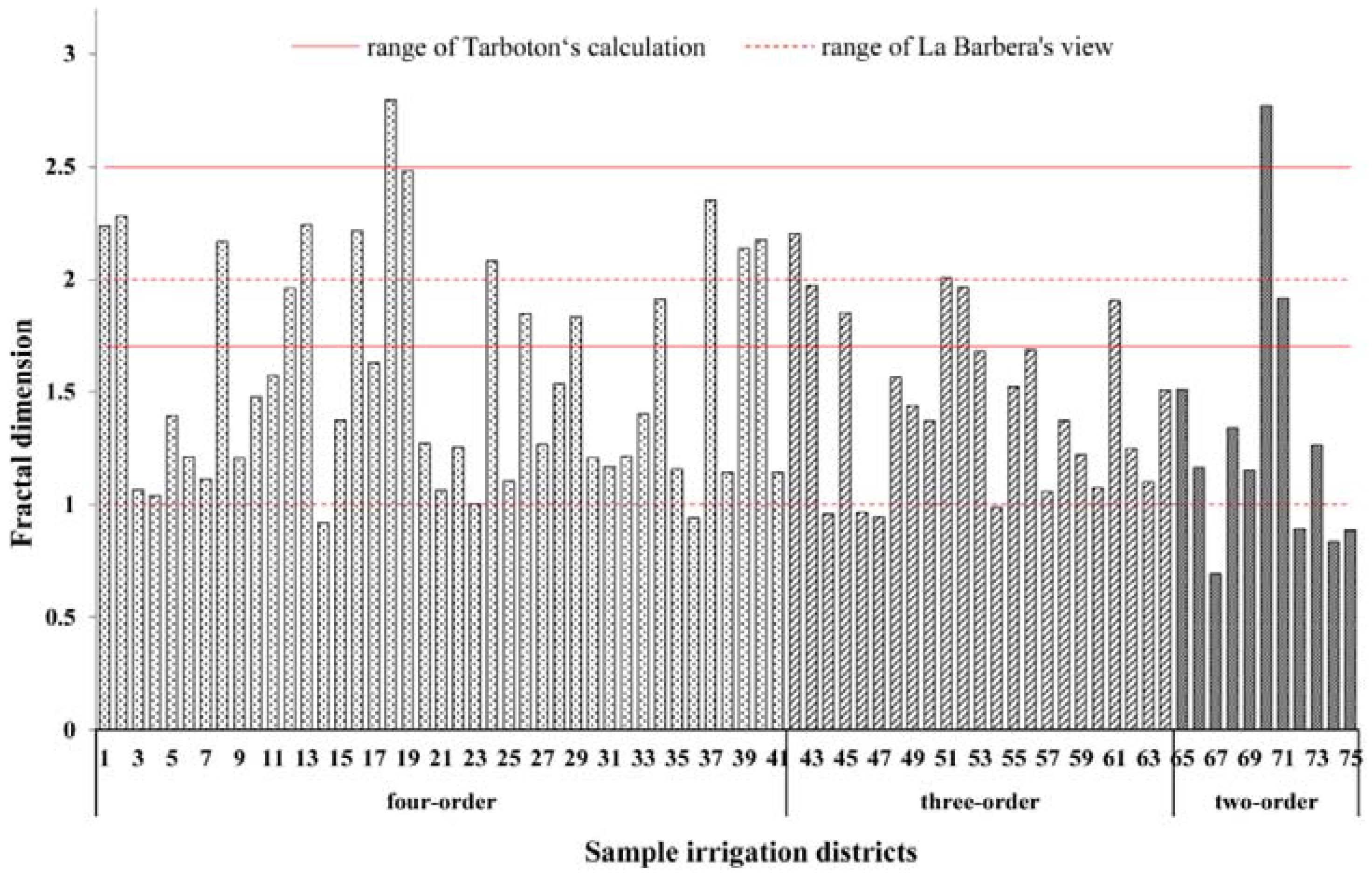
Equation (5) indicates a scaling behavior of the channel network in which channel segments in the form of a line organize a type of network structure to fully drain a basin in the form of a plane by a bifurcation process, which is a space-filling process of channel networks. The fractal dimension D calculated by Tarboton et al. [36] was between 1.7 and 2.5. However, La Barbera et al. [37] believed that water systems with a fractal dimension between 1 and 2 was most consistent with the natural conditions, and the average value was 1.6–1.7.
2.2.3. Calculation of the Complexity of Canal Structure
When applying the relevant laws of river networks to canal network research, the parameters of the river are all replaced by canal parameters. In addition, the eigenvalues of canal structures can also be expressed via drainage density [38], stream frequency, and river naturalness. When the three eigenvalues are applied to canal networks, they are called canal density, canal frequency, and canal naturalness.
Canal Density
Drainage density (Dd) measures how much of an area is occupied by streams, that is, how well-developed a drainage system is [39]. In our study, drainage density yields information on canal development. Thus, canal density (Cd) is calculated as follows:
where L is the accumulated canal length, in km; and A is the network area, in km2.
Canal Frequency
Stream frequency (Fs) is the ratio between the total number of streams (N) over a given area [40]. In our case, the canal frequency (Cf) is calculated as follows:
where N is the accumulated number of canals and A is the network area, in km2.
Canal Naturalness
Based on a comprehensive consideration of the length of the river network and the level of branches, Yang et al. [40] proposed another index that describes the structure of river network drainage systems, the river naturalness (Rc). The equation for canal naturalness (Cn) was rewritten as follows:
where Ω is the order of the network’s main canal; L is the accumulated canal length, in km; and Lg is the length of the main canal, in km.
In this research, the naturalness of the canal structure reflects the development degree of the number and length of canals. A higher value indicates more abundant canal systems and more developed branch canals.
2.3. Investigation
To verify the theoretical results, we conducted field investigation. We selected one with larger fractal dimension and one with smaller fractal dimension in each of the ordered irrigation districts. The investigation included the structure of the canal system of the irrigation districts, the filling extent of the canal system to the irrigation field, and the ability to meet the irrigation needs.
3. Results
3.1. Complexity of the Distribution Structure of the Canal Systems
According to Equations (2)–(8), the characteristic values of various canal-level types of irrigation districts were calculated. To clarify the results, the average values were used for the analysis as shown in Table 1.
The following results were observed: (1) The canal characteristics of canal density, canal frequency, and canal naturalness in the four-order irrigation districts were the highest among the three types of districts, and they were many times higher than the three-order and two-order irrigation areas, indicating that the canal structure of four-order irrigation areas was the most complex. The canal density of the four-order irrigation districts was lower than that of the other two types, indicating that although the number of canals in the four-order irrigation districts was large, the total length of the canal system was shorter. The length ratio and bifurcation ratio of the four-order irrigation districts were within the general range of the Horton’s law. Within the general range, it was indicated that the canal system conforms to the fractal rules of water systems. Thus, four-order canal irrigation areas were generally consistent with a natural self-organizing optimization structure. Under this structure, irrigation water can be effectively distributed to fields. (2) The average effective irrigation area of the three-order irrigation areas, which was primarily intermediate, was slightly lower than that of the four-order irrigation area. The bifurcation ratio was the highest among the three types, and the length ratio was intermediate. In certain three-order irrigation districts, the bifurcation ratio or length ratio exceeded the general value range of Horton’s laws. The higher branching ratio is a result of the large difference between the number of channels in each grade, with a small number of main channels and a large number of sublateral canals. The irrigation system of the three-order irrigation districts was dominated by short and medium-length canals with many more branches. The length ratio was relatively high because a longer main canal was observed in the irrigation district, whereas the lateral canal and sublateral canals for water distribution were shorter. (3) The two-order irrigation districts are mainly small-scale districts. Their length ratio was the highest among the three types of irrigation areas, indicating that this type of irrigation district was dominated by long-distance water conveyance channels with few branches.
Lower level canals extend as the irrigation area increases. Although the canal extension can transport irrigation water to more distal areas in the field, the IWUE will decrease as the canals are extended. The average canal density of the four-order irrigation districts was the largest, although the average IWUE was the lowest. The characteristics of the canal system led to water loss, including canal seepage loss and conveyance water surface evaporation loss. Therefore, canal seepage loss accounted for most of the canal water loss. The length of the canal system, the soil quality of the canal bed, and the canal antiseepage measures were related to seepage loss. Longer canal systems corresponded to more leakage and evaporation losses.
3.2. Analysis of the Fractal Dimension of Canal System in Irrigation Districts
According to Equation (5), the dimensions of each irrigation district are shown in Figure 3. The dimension values of the sampled irrigation districts were concentrated between 1 and 2.5, which was within the regular range of the fractal values of Horton’s laws. Ten irrigated areas have a fractal dimension below 1, and Equation (5) shows that the bifurcation ratio is smaller than the length ratio. The bifurcation ratios in this type of irrigated area were on the upper boundary of the general range. Most irrigation areas with fractal dimensions less than 1 had a larger scale, and although the length of the canal system was long, the area was large; therefore, the number of channels in the unit area of the irrigation area was small. As a result, the canal system cannot effectively fill the irrigation area, thus making the fractal dimension smaller. Two irrigation systems had a dimension value higher than the upper limit of 2.5: the Hongwei Irrigation District and the Bayi Irrigation District. Among these districts, the bifurcation ratio of Hongwei Irrigation District is as high as 11.347, the length ratio was only 2.38, the number of sublateral canals was 11 times that of lateral canals, and the length of sublateral canals was only 4 times that of lateral canals. In the process of constructing channels, too much emphasis was placed on quantity, and excavation to a suitable length was not observed. Artificially excavated canals are different from natural river channels, and artificial construction engineering means that the canal system does not have a self-similar structure as observed for natural river networks. This feature resulted in situations where the fractal dimension was too high or too low. The values of the canal fractal dimensions for more than half of the studied irrigation districts were 1.0–1.5. The literature review and field investigation showed that within a reasonable range, a greater fractal dimension of the canal system corresponds to better development of the canal structure [14,41,42]. Therefore, the canal structure still needs to be further optimized.
3.3. Influence of Canal Complexity on the Irrigation Water Use Efficiency
3.3.1. Variation in Irrigation Districts with Different Canal Orders
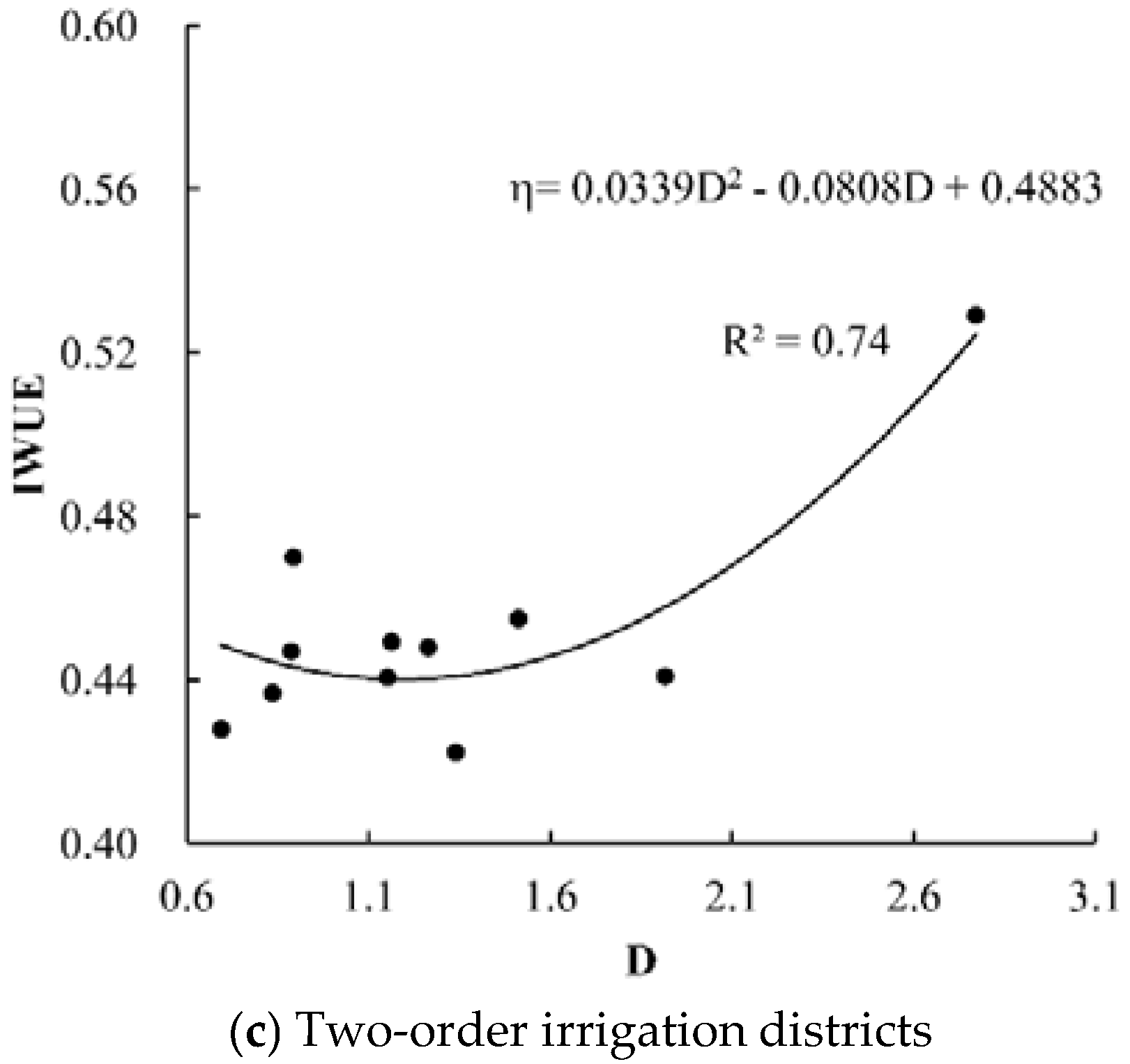
The canal water use efficiency has a direct effect on the IWUE. It is closely related to the canal length, complexity, lining rate, and soil texture. The fractal dimension characterizes the canal parameters and can reflect the rationality of the conveyance of the canal system water from a different perspective. Improving the IWUE by finding the best fractal dimension D, which is based on the branch ratio and length ratio, is of great theoretical and practical significance. The correlation between the IWUE and D in the irrigation districts with different canal orders was analyzed. As shown in Figure 4, the general trend of the changes in the IWUE in Heilongjiang irrigation districts was analyzed.
The relationship between the IWUE and fractal dimension D can be seen in Figure 4: (1) the four-order fitting curve was a large-opening parabola with a trend change point. As the D value increased, the IWUE showed an overall trend of initially decreasing and then increasing. (2) The fitting trend line of the IWUE and D values in the three-order irrigation districts had no obvious morphological characteristics, and the overall shape was a parabola with a smaller opening. Similar to the four-order canal irrigation districts, the IWUE of the three-order irrigation districts initially decreased and then increased as the fractal dimension increased, and the growth trend was more obvious than that of the four-order districts. The canal frequencies of the three-order and four-order canals should not be too high, and the length of the branch canal system should be appropriately extended. (3) The number of two-order canals in the sample irrigation districts was small; therefore, the distribution of points showed a higher correlation (R2 = 0.7413) and the IWUE increased as the D value increased. When the canal system had less grading and a simple channel structure, increasing the bifurcation ratio of the canal system increased the efficiency of the irrigation water delivery to the field, which will be conducive to the improving the IWUE.
In the three-order and four-order irrigation districts, the IWUE decreased with a certain interval as D increased. Considering the influence of the irrigation area, further analysis of this phenomenon will be conducted.
3.3.2. Variation in Irrigation Districts with Different Areas
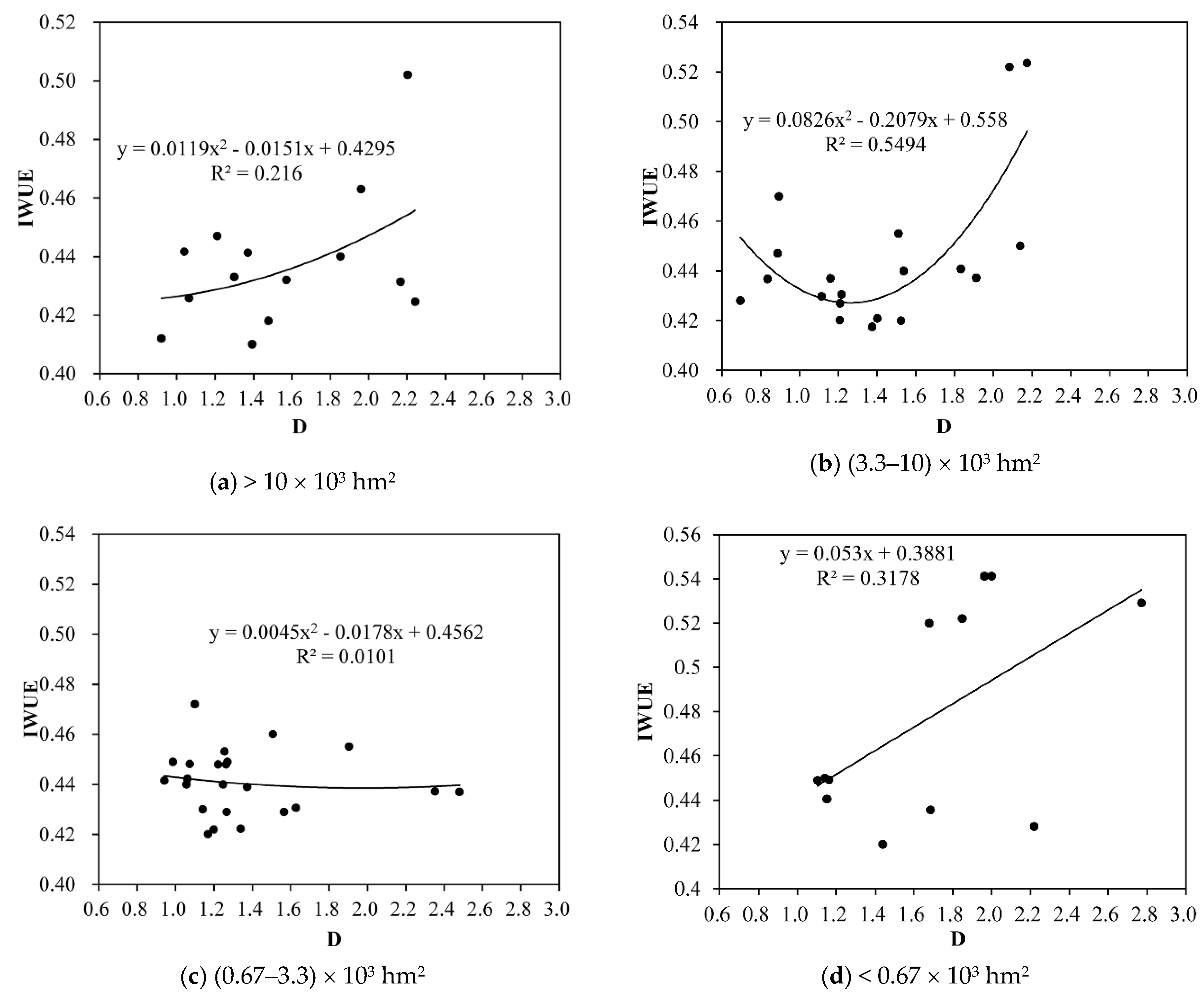
According to the rules of the irrigation district-scale divisions in China, irrigation districts are divided into large irrigation areas (more than 2 × 10⁴ hm2), medium irrigation areas ((0.67–3.3) × 103 hm2, (3.3–10) × 103 hm2, (10–20) × 103 hm2), and small irrigation areas (less than 0.67 × 10³ hm2). The three- or four-grade irrigation areas are divided into four groups according to the above division method. Because fewer large-scale irrigation districts were observed in the study area, areas between 2 × 10⁴ hm2 and (10–20) × 103 hm2 were merged into areas >10 × 103 hm2, as shown in Figure 5.
As shown in Figure 5, in the three- and four-grade irrigation areas, (1) the IWUE of the irrigation districts with an area of more than 10 × 103 hm2 generally increased as the fractal dimension increased, which showed that increasing the complexity of the canal system can increase the IWUE. Combined with Equation (5) above, increasing the fractal dimension can be achieved by increasing the bifurcation ratio and decreasing the length ratio. Properly lengthening the bifurcation canal system and increasing the number of canal systems so that the canal system can fully fill the irrigation area, and the diverted irrigation water can be more efficiently transported to the fields. (2) A high correlation was observed between the IWUE and D in the (3.3–10) × 103 hm2 irrigation district (R2 = 0.5494), which indicated that the correlation between the D value for the medium-scale irrigation district and the IWUE was stronger and variations in the values of D had a great influence on the IWUE. Two singular points were observed, and the fitting curve showed a significant decrease before and after the increase; however, most of the data showed a trend in which the IWUE decreased along with D. The data showed that certain water conveyance channels were relatively redundant in these irrigation areas. When the canal length meets the irrigation demand, more refined canal systems may cause more leakage and evaporation losses. At this time, the IWUE can be improved by transforming the canal systems by changing long canals into short canals and increasing the impermeability rate to enhance the water transport capacity. (3) Clear morphological characteristics were not observed for the curve fitted for the (0.67–3.3) × 103 hm2 area, the overall performance decreased, and the fractal dimension was concentrated between 1.0 and 1.4. The lower complexity of the canal system was sufficient to meet the irrigation needs of the crops; thus, increasing the numbers of the canals was relatively redundant for such smaller irrigation areas. (4) A clear trend was not observed for the curve for the IWUE and D of irrigation districts with areas below 0.67 × 10³ hm2. Because of the smaller area, the distribution of irrigation channels may have a lower impact on the IWUE.
4. Discussion
The analysis found a relatively high IWUE in irrigation districts under different canal order and area classifications; thus, a relatively optimal distribution of the canal system structure for water supply was observed. To obtain the influence of the change in fractal dimension on the IWUE of each irrigation district, the area of the irrigation districts should be combined for specific calculations.
Effect of Fractal Dimensions on Potential IWUE Enhancements
The irrigated effective area and irrigation water consumption of each irrigation area exhibited little differences between years. To intuitively understand the effect of changes in D on the IWUE, other influencing factors were excluded, and only the fractal dimension (D), water consumption volume (Q), effective irrigation area (S), and IWUE of the sample irrigation districts were used to fit the formula. The single-value points were excluded, and the data on 50 irrigation districts were retained. Then, the multiple nonlinear regression method in SPSS 19.0 was applied, and after many iterations, the fitting formulae were as follows:
The correlation coefficient obtained by model fitting was 0.6, and the test of significance was F = 66.97. Referring to the table of F test critical values, when α = 0.05 and the degrees of freedom were n = 48, the critical value of F was 2.798 (66.97 > 2.798). The correlation coefficient between the IWUE and variables was significant. Because the fitting formula curve was a parabola that opens upwards, the IWUE will decrease as the fractal dimension increases. The minimum value of the curve obtained by mathematical derivation was 0.73. If we do not consider other engineering influencing factors, after the fractal dimension reached 0.73, a positive correlation was observed between the IWUE and the change in fractal dimension.
The increasing potential of the IWUE represents the change value resulting from increasing the fractal dimension of the irrigation canal system. An increased IWUE potential means that the fractal dimension is considered the main factor, other influencing factors are considered, and the influence degree of the canal system after the transformation of the canal system is described. The calculation formula is as follows:
where Δη is the change in the value of IWUE, f(x) is a fitting formula for IWUE and its influencing factors, n is the change in fractal dimension, and x1…xn are other influencing factors.
To analyze the influence of the canal structure transformation on the IWUE, the fractal dimension was increased and other variables were held unchanged. Equations (9) and (10) are combined to obtain the value of the enhancement potential of the IWUE under conditions in which the canal fractal dimension increases.
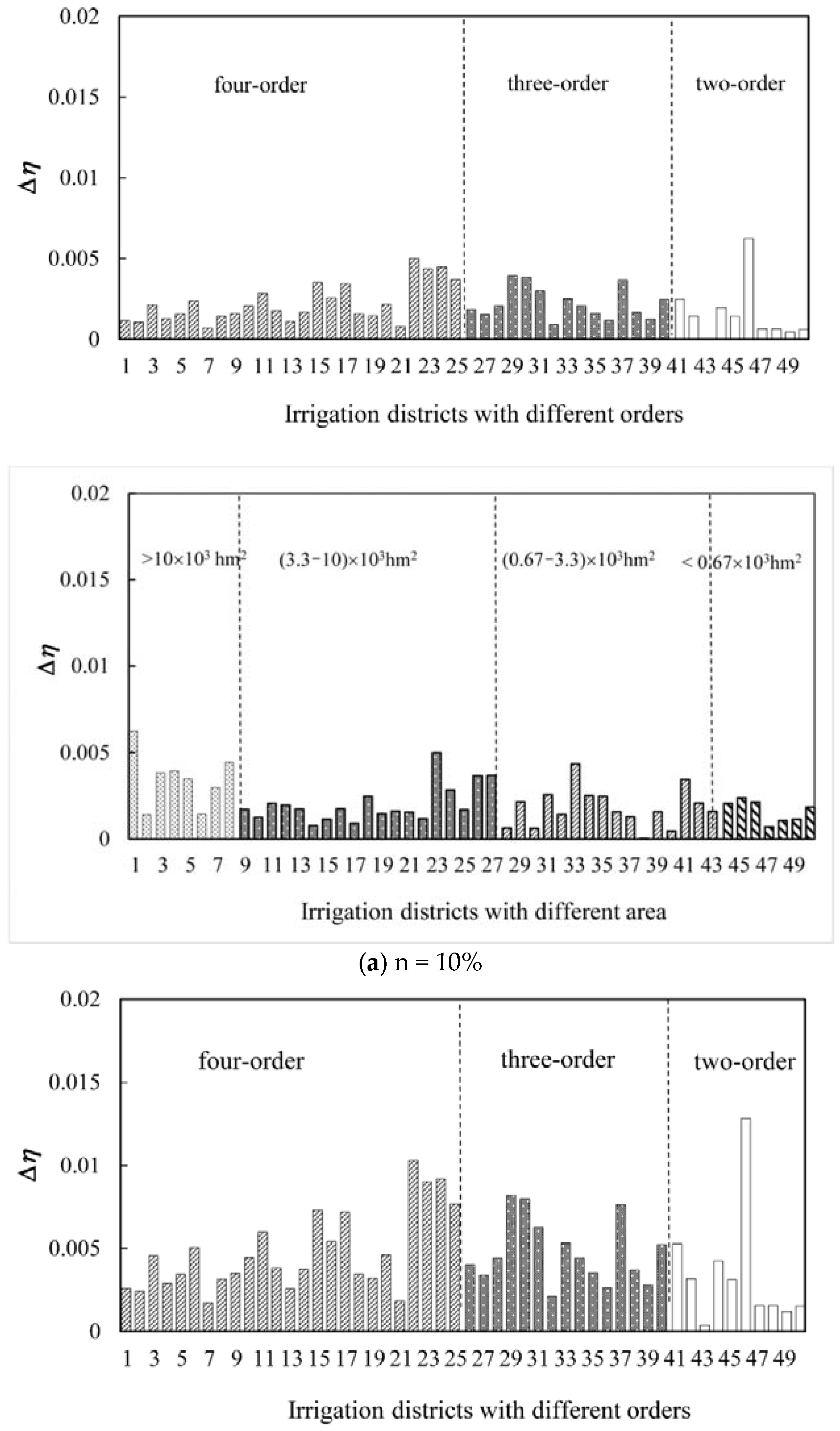
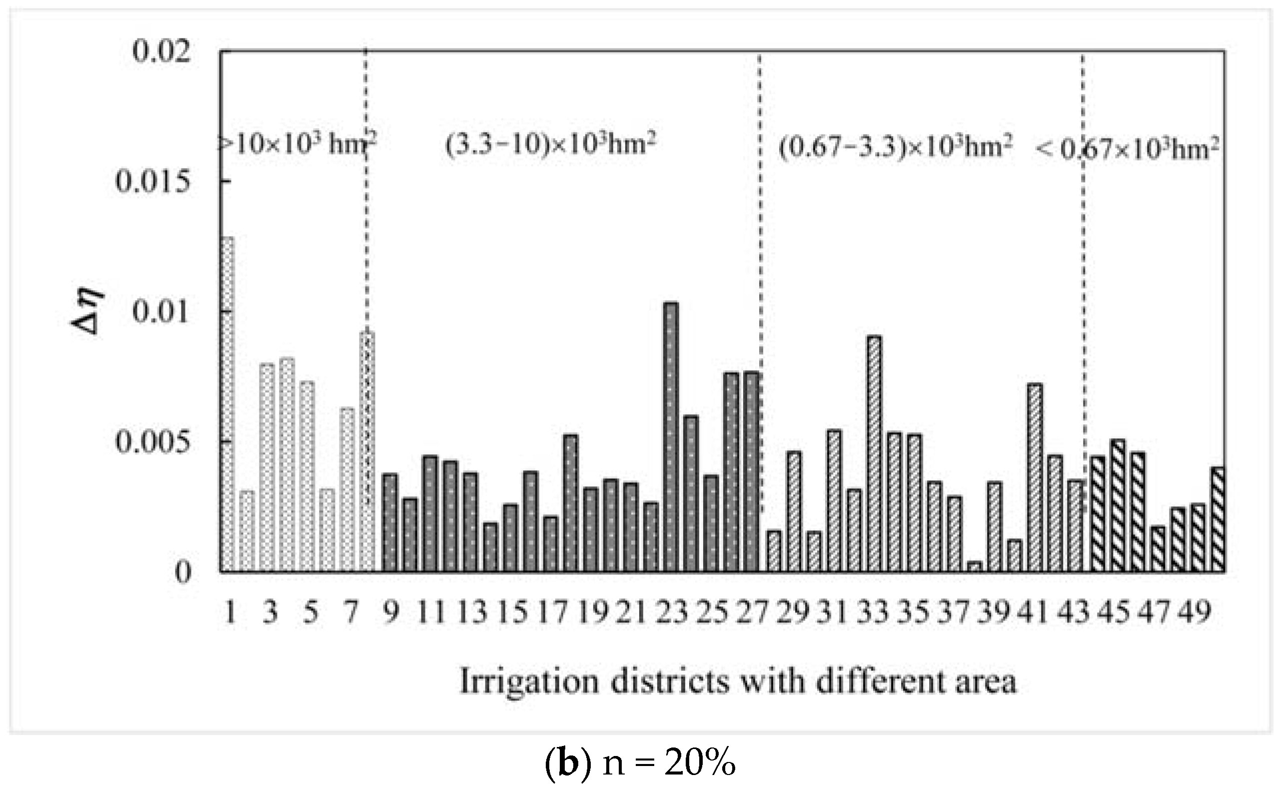
Because the dimensions have a certain range of values, the Δη values of each irrigation district at n = 10% and 20% were calculated as shown in Figure 6.
Figure 6a,b show that the IWUE was more sensitive to the increase in fractal dimension in more than half of the four-order and two-order irrigation areas. When the fractal dimension value increased, the IWUE increased greatly. When the D value increased by 10%, no clear change in the IWUE was observed in each irrigation area. When the value of D increased by 20%, the increased IWUE value in irrigation districts with higher fractal dimensions reached more than 0.01. Therefore, to achieve a certain improvement in the irrigation water use factor, the fractal dimension of the canal system should be increased by at least 20%. When divided by area, the change in IWUE in irrigation districts less than 0.67 × 10³ hm2 and (0.67–3.3) × 103 hm2 was larger. In summary, as the fractal dimension of a canal system increased, the IWUE potential showed a greater increase in the four-order and three-order irrigation districts with areas less than 3.3 × 10³ hm2. The IWUE in the four-order irrigation districts with large-scale had the smallest potential increase because the canal structure of this type of irrigation district was better than that of other types; therefore, the IWUE presented less room for improvement via canal transformation.
Although the theoretical calculations showed that when the channel fractal dimension was higher than 0.73, as long as the fractal dimension continued to increase, the IWUE increased. Therefore, in the process of reconstruction, the actual situation needs to be considered, meaning that whether or not the water savings benefits resulting from canal system improvements are greater than the required input should be evaluated. The IWUE is influenced by various factors. This paper studied only the distribution characteristics of the IWUE from the perspective of canal systems and attempted to provide a theoretical reference for managers for improving the IWUE from an engineering perspective.
5. Conclusions
In this paper, the fractal dimension of a canal system was calculated by Horton’s law to characterize the complexity of the canal system. The relationship between the canal structure and IWUE in different types of irrigation districts and the degree of influence on the IWUE were analyzed. It provided an important technical support for the reform and design of irrigation districts with different scales, types, and canal orders.
Through the analysis and comparison with the findings of field investigations, the results showed that the structure of canal system was more complicated with the increase of canal orders, and canal structure in four-order irrigation districts were the best for irrigation conveyance. This was because the canal system structure of four-order districts was the most consistent with water networks that follow the laws of nature. The suggestion for large irrigation districts with canals of less than four orders was that the number of canal orders should be improved. When the canal system approximates a natural self-organizing optimized structure, irrigation water can be effectively distributed to the field under the action of gravity.
Suggestions are provided for different types of irrigation districts without changing the channel progression. In three- and four-level irrigation districts, irrigation districts with areas more than 10 × 103 hm2 should increase the branch ratio or reduce the length ratio because appropriately lengthening the bifurcation canal system and increasing the number of canal systems can allow the canal system to fully fill the irrigation area. Irrigation districts with areas of (3.3–10) × 103 hm2 can increase the IWUE by changing long canals into short canals and increasing the canal impermeability rate to enhance water transport capacity. Irrigation districts below 3.3 × 10³ hm2 can increase the IWUE by increasing the fractal dimension to 1.8; moreover, the lower canal complexity could meet the irrigation demand, and the number of canals did not need to increase. Increasing the fractal dimension of the two-order irrigation districts can improve the IWUE, although the change was not significant. Improving the IWUE through canal system transformation was not recommended. According to the analysis of fractal dimension changes, the IWUE of the four-order and two-order irrigation districts below 3.3 × 10³ hm2 had more room for improvement through canal transformation. The canal structure of the four-order irrigation districts with relatively large areas was relatively optimal, and the IWUE had the lowest potential for enhancement.
Author Contributions
Q.F. and T.X.L. designed the study. M.X.S. wrote the manuscript. S.C. and D.L. reviewed and approved the manuscript.
Funding
This research was funded by the National Key R&D Plan [2017YFC0406002] and the National Natural Science Foundation of China [51709044 and 51479032].
Acknowledgments
The authors acknowledge with satisfaction the valuable suggestions made by anonymous reviewers and the editors which have helped transform this version into a better one.
Conflicts of Interest
The authors declare no conflicts of interest.
References
- Bos, M.G. Standards for Irrigation Efficiencies of ICID. J. Irrig. Drain. Div. 1979, 105, 37–43. [Google Scholar]
- Ministry of Water Resources. Technical Terminology Far Rural Water Conservancy; China Water Power Press: Beijing, China, 2005. (In Chinese) [Google Scholar]
- Howell, T.A. Irrigation Eficiency. Dict. Geotech. Eng./Wörterbuch Geotech. 2003, 385–391, 398. [Google Scholar]
- Jia, R.; Fang, S.; Tu, W.; Sun, Z. Driven Factors Analysis of China’s Irrigation Water Use Efficiency by Stepwise Regression and Principal Component Analysis. Discret. Dyn. Nat. Soc. 2016, 2016, 8957530. [Google Scholar] [CrossRef]
- Reid, P.C.M.; Davidson, D.C.R.; Grift, M. Factors Influencing Conveyance Efficiency. In Irrigation Systems for the 21st Century; ASCE: Reston, VA, USA, 2010. [Google Scholar]
- Shrief, S.A.; El-Mohsen, A.A.A. Regression models to describe the influence of different irrigation regimes on grain yield and water use efficiency in bread wheat. Adv. Agric. Boil. 2015, 4, 39–49. [Google Scholar]
- Fu, Q.; Liu, W.; Liu, D.; Li, T.; Cui, S. Fractal Characteristics and Influence Factors Analysis of Irrigation Water Use Efficiency in Heilongjiang Province. Trans. Chin. Soc. Agric. Mach. 2016, 47, 147–153. [Google Scholar]
- Wang, X.J.; Zhang, Q. Static and dynamic analysis of factors affecting the efficient utilization coefficient of irrigation water in Guangdong Province. Adv. Sci. Technol. Water Resour. 2015, 35, 6–11. [Google Scholar]
- Zheng, S.Z.; Jia, H.Z.; Cui, Y.L. Influencing Factors and Laws on Canal Water Conveyance Efficiency. J. Irrig. Drain. 2013, 32, 76–77. [Google Scholar]
- Wang, J.F.; Ma, X.; Zhou, H.B. Design of the seepage-proofing canal with soil protective layer geomembrane based on the multi-objective fuzzy optimization. Trans. Chin. Soc. Agric. Eng. 2008, 24, 1–5. [Google Scholar]
- Shah, M.A.A.; Anwar, A.A.; Bell, A.R.; Haq, Z.U. Equity in a tertiary canal of the Indus Basin Irrigation System (IBIS). Agric. Water Manag. 2016, 178, 201–214. [Google Scholar] [CrossRef]
- Bolea, Y.; Puig, V. Gain-scheduling multivariable LPV control of an irrigation canal system. ISA Trans. 2016, 63, 274–280. [Google Scholar] [CrossRef] [PubMed] [Green Version]
- Delgoda, D.; Malano, H.; Saleem, S.K.; Halgamuge, M.N. A novel generic optimization method for irrigation scheduling under multiple objectives and multiple hierarchical layers in a canal network. Adv. Water Resour. 2017, 105, 188–204. [Google Scholar] [CrossRef]
- Liu, B.J.; Shao, D.G.; Shen, X.P. Fractal features of irrigation canal system in irrigation district. Trans. Chin. Soc. Agric. Eng. 2005, 21, 56–59. [Google Scholar]
- Veltri, M.; Veltri, P.; Maiolo, M. On the fractal description of natural channel networks. J. Hydrol. 1996, 187, 137–144. [Google Scholar] [CrossRef]
- Bartolo, S.G.D.; Veltri, M.; Primavera, L. Estimated generalized dimensions of river networks. J. Hydrol. 2006, 322, 181–191. [Google Scholar] [CrossRef]
- Shen, X.H.; Zou, L.J.; Zhang, G.F.; Su, N.; Wu, W.Y.; Yang, S.F. Fractal characteristics of the main channel of Yellow River and its relation to regional tectonic evolution. Geomorphology 2011, 127, 67–70. [Google Scholar] [CrossRef]
- Puente, C.E.; Castillo, P.A. On the fractal structure of networks and dividers within a watershed. J. Hydrol. 1996, 187, 173–181. [Google Scholar] [CrossRef]
- Claps, P.; Fiorentino, M.; Oliveto, G. Informational entropy of fractal river networks. J. Hydrol. 1996, 187, 145–156. [Google Scholar] [CrossRef] [Green Version]
- Schuller, D.J.; Rao, A.R.; Jeong, G.D. Fractal characteristics of dense stream networks. J. Hydrol. 2001, 243, 1–16. [Google Scholar] [CrossRef]
- Kim, J.C.; Jung, K. Fractal Tree Analysis of Drainage Patterns. Water Resour. Manag. 2015, 29, 1217–1230. [Google Scholar] [CrossRef]
- Moussa, R. Definition of new equivalent indices of Horton-Strahler ratios for the derivation of the Geomorphological Instantaneous Unit Hydrograph. Water Resour. Res. 2009, 45, 63–69. [Google Scholar] [CrossRef]
- Mantilla, R.; Gupta, V.K.; Troutman, B.M. Extending generalized Horton laws to test embedding algorithms for topologic river networks. Geomorphology 2012, 151–152, 13–26. [Google Scholar] [CrossRef]
- Zhang, S.; Guo, Y.; Wang, Z. Correlation between flood frequency and geomorphologic complexity of rivers network—A case study of Hangzhou China. J. Hydrol. 2015, 527, 113–118. [Google Scholar] [CrossRef]
- Yang, L.; Xu, Y.; Han, L.; Song, S.; Deng, X.; Wang, Y. River networks system changes and its impact on storage and flood control capacity under rapid urbanization. Hydrol. Process. 2016, 30, 2401–2412. [Google Scholar] [CrossRef]
- Stankiewicz, J.; Wit, M.J.D. River networks of southern Africa: Scaling laws governing their geometry and deviations from scaling. Geochem. Geophys. Geosyst. 2005, 6, 1–19. [Google Scholar] [CrossRef]
- Fu, Q.; Liu, Y.; Li, T.; Liu, D.; Cui, S. Analysis of irrigation water use efficiency based on the chaos features of a rainfall time series. Water Resour. Manag. 2017, 31, 1961–1973. [Google Scholar] [CrossRef]
- Cheng, K.; Fu, Q.; Li, T.-X.; Jiang, Q.; Liu, W. Regional Food Security Risk Assessment under the Coordinated Development of Water Resources. Nat. Hazards 2015, 78, 603–619. [Google Scholar] [CrossRef]
- Hu, Q.; Wu, W.B.; Song, Q.; Miao, L.U.; Chen, D.; Yu, Q.Y.; Tang, H.J. How do temporal and spectral features matter in crop classification in Heilongjiang Province, China? J. Integr. Agric. 2017, 16, 324–336. [Google Scholar] [CrossRef]
- Kirchner, J.W. Statistical inevitability of Horton’s laws and the apparent randomness of stream channel networks. Geology 1993, 21, 591–594. [Google Scholar] [CrossRef]
- Jiao, X.; Yang, B.; Pei, Z. Paddy rice area estimation using a stratified sampling method with remote sensing in China. Trans. Chin. Soc. Agric. Eng. 2006, 22, 105–110. [Google Scholar]
- Neyman, J. On the Two Different Aspects of the Representative Method: The Method of Stratified Sampling and the Method of Purposive Selection. J. R. Stat. Soc. 1934, 97, 558–625. [Google Scholar] [CrossRef]
- Alexandersson, H. A homogeneity test applied to precipitation data. J. Clim. 2010, 6, 661–675. [Google Scholar] [CrossRef]
- Slonosky, V.C.; Jones, P.D.; Davies, T.D. Homogenization Techniques for European Monthly Mean Surface Pressure Series. J. Clim. 1999, 12, 2658–2672. [Google Scholar] [CrossRef]
- La Barbera, P.; Rosso, R. Fractal geometry of river networks. Eos Trans AGU 1987, 68, 1276. [Google Scholar]
- Tarboton, D.G.; Bras, R.L.; Rodriguez-Iturbe, I. The fractal nature of river networks. Water Resour. Res. 1988, 24, 1317–1322. [Google Scholar] [CrossRef]
- La Barbera, P.; Rosso, R. On the fractal dimension of stream networks. Water Resour. Res. 1989, 25, 735–741. [Google Scholar] [CrossRef]
- Tubau, X.; Lastras, G.; Canals, M.; Micallef, A.; Amblas, D. Significance of the fine drainage pattern for submarine canyon evolution: The Foix Canyon System, Northwestern Mediterranean Sea. Geomorphology 2013, 184, 20–37. [Google Scholar] [CrossRef]
- Horton, R.E. Erosional development of streams and their drainage basins: Hydrophysical approach to quantitative morphology. J. Jpn. For. Soc. 1945, 56, 275–370. [Google Scholar] [CrossRef]
- Yang, K.; Yuan, W.; Zhao, J. Stream structure characteristics and its urbanisation responses to Tidal River system. Acta Geogr. Sin. 2004, 59, 557–564. [Google Scholar]
- Qu, Z.Y.; Yang, X.; Huang, Y.J.; Du, B.; Yang, J. Analysis of efficiency of water utilization in canal-system in Hetao irrigation district based on Horton fractal. Trans. Chin. Soc. Agric. Eng. 2015, 31, 120–127. [Google Scholar]
- Wang, X.J.; Zhang, Q.; Yi, X.B.; Xiao, M.Z. Study on the Horton fractal dimension with the irrigation canal system characteristics and effective utilization coefficient of irrigation water. Geogr. Res. 2014, 33, 789–800. [Google Scholar]
Figure 1.
Distribution map of the irrigation area studied in Heilongjiang Province.

Figure 2.
The diagram of methodology. IWUE—irrigation water use efficiency.

Figure 3.
Fractal dimension of the canal system in the sample irrigation areas.

Figure 4.
Scatter chart of the IWUE and D values for canal systems at all levels and classified sampled irrigation districts.
Figure 4.
Scatter chart of the IWUE and D values for canal systems at all levels and classified sampled irrigation districts.


Figure 5.
Scatter chart of IWUE and D values with canal systems presenting different irrigation district areas.
Figure 5.
Scatter chart of IWUE and D values with canal systems presenting different irrigation district areas.

Figure 6.
Change in irrigation water use efficiency with increases in D.


Table 1.
Canal system characteristics of sample irrigation districts.
| Type | Number | Effective Irrigation Area (km2) | Bifurcation Ratio | Length Ratio | Canal Density (km·km−2) | Canal Frequency (canal·km−2) | Canal Naturalness |
|---|---|---|---|---|---|---|---|
| Four order | 41 | 78.27 | 5.00 | 2.85 | 392.56 | 730.46 | 53.98 |
| Three order | 23 | 66.12 | 6.49 | 3.95 | 283.64 | 235.28 | 17.15 |
| Two order | 11 | 49.09 | 5.28 | 4.19 | 142.49 | 42.417 | 7.1548 |
© 2018 by the authors. Licensee MDPI, Basel, Switzerland. This article is an open access article distributed under the terms and conditions of the Creative Commons Attribution (CC BY) license (http://creativecommons.org/licenses/by/4.0/).
Share and Cite
MDPI and ACS Style
Li, T.; Sun, M.; Fu, Q.; Cui, S.; Liu, D. Analysis of Irrigation Canal System Characteristics in Heilongjiang Province and the Influence on Irrigation Water Use Efficiency. Water 2018, 10, 1101. https://doi.org/10.3390/w10081101
AMA Style
Li T, Sun M, Fu Q, Cui S, Liu D. Analysis of Irrigation Canal System Characteristics in Heilongjiang Province and the Influence on Irrigation Water Use Efficiency. Water. 2018; 10(8):1101. https://doi.org/10.3390/w10081101
Chicago/Turabian StyleLi, Tianxiao, Mengxin Sun, Qiang Fu, Song Cui, and Dong Liu. 2018. "Analysis of Irrigation Canal System Characteristics in Heilongjiang Province and the Influence on Irrigation Water Use Efficiency" Water 10, no. 8: 1101. https://doi.org/10.3390/w10081101
Note that from the first issue of 2016, this journal uses article numbers instead of page numbers. See further details here.