Seasonal Variation of Drainage System in the Lower Ablation Area of a Monsoonal Temperate Debris-Covered Glacier in Mt. Gongga, South-Eastern Tibet


1
Institute of Mountain Hazards and Environment, Chinese Academy of Sciences, Chengdu 610041, China
2
Institute of International Rivers and Eco-security, Yunnan University, Kunming 650500, China
3
Administration Bureau of Hailuogou in Ganzi Tibetan Autonomous Prefecture, Sichuan 626102, China
*
Author to whom correspondence should be addressed.
Water 2018, 10(8), 1050; https://doi.org/10.3390/w10081050
Submission received: 2 July 2018
/
Revised: 29 July 2018
/
Accepted: 3 August 2018
/
Published: 8 August 2018
(This article belongs to the Special Issue The Nexus of Alpine Glacier Watersheds, Climate Change and Human Activity)
Abstract
:Seasonal evolution of the subglacial drainage system in the lower ablation area of the Hailuogou glacier ice tongue were revealed by repeated dye tracer (Rhodamine WT) experiments during the 2009 ablation season. Between April and October, 18 dye tracer experiments were conducted by injecting the tracer at one location of the lower ablation area of the Hailuogou Glacier to diagnose the seasonal variation of the subglacial drainage system of this section of glacier ice tongue. Using a simple advection-dispersion model (ADM), the flow velocity, hydrodynamic dispersion coefficient, and degree of tracer spreading were deduced. Tracer transit velocity through the tested subglacial channel varied from 0.148 to 0.555 m s−1 during the 2009 ablation season. Dispersivity showed a relatively high value than that found at other glaciers, which varied between 27.05 and 287.49 m2 s−1. Seasonal changes of these indexes indicated that the subglacial drainage system of the lower ablation area of the Hailougou Glacier is a relatively stable existing system in the case of its longitudinal shape, whereas its hydraulic efficiency is low in the early and late ablation seasons and high during the middle of summer due to subglacial channel expansion.
1. Introduction
Recent observations and modeling studies on either mountain valley glaciers or ice sheets have highlighted the role of subglacial water in ice flow processes (e.g., [1,2,3,4,5]). Studies on polar glaciers have suggested that enhanced melting has induced ice-sheet flow accelerations [6], whereas some modeling analysis indicated that those accelerations were primarily determined by melting supply variability [7] and the speed-up may be offset by efficient subglacial drainage [8]. For mountain glaciers, many observations and experiments have been carried out to understand the subglacial hydrology and it is much clearer that subglacial hydrological processes influence the glacier dynamics [5,9,10,11], runoff processes [12,13,14,15], and subglacial weathering intensities [16,17,18]. The knowledge of subglacial drainage system conditions and evolution, therefore, can potentially contribute to the improvement of glacier flow model and glacial runoff simulation.
Subglacial drainage system evolution of some mountain glaciers is conceptualized as a morphological transition from a slow or distributed drainage network to a fast or channelized drainage system over the course of the melt season [19,20]. This transition induces subglacial hydraulic changes and therefore could be indicated by the tracing experiments, which have been widely used in the study of englacial and subglacial drainage system development and evolution (e.g., [21,22,23,24,25,26]). Tracer experiments provide information about the hydraulic conditions of a drainage system if the tracer transport is identical to the flow of individual water particles [27]. The englacial and subglacial drainage system of some alpine glaciers have been characterized by proglacial discharge analysis such as discharge-temperature (Q-T) cross correlation analysis [14], principal component analysis, and cluster analysis [28,29].
Monsoonal temperate glaciers are widely distributed in the south east of the Tibetan Plateau [30,31]. Particularly, temperate glaciers in this region are due to summer accumulation, receiving most new snowfall in summer while simultaneously experiencing high ablation, making them characterized by a high rate of mass turnover and high ice flow velocity [32]. The recent shrinkage and hydrological responses that have occurred on these temperate glaciers are remarkable [33]. The glacial drainage system can either cause or respond to the enhanced ablation across the ablation area of debris-covered glaciers due to warming [34]. High frequency debris flow and glacial outburst floods in this region [35] probably relate to the drainage systems evolution of glaciers in their upper valley. However, we know little about the water flow processes through these glaciers, which plays an important role in ice flow dynamics and further in mass balance changes.
In this study, to understand the formation and evolution of the subglacial hydrological system of the monsoonal temperate glaciers, we employed a series of dye tracing experiments over a complete ablation season in 2009 at the lower ice tongue of the Hailuogou Glacier (HLG), a typical monsoonal temperate glacier in south-eastern Tibet. Tracer return curves (TRC) were modelled using a transport model and, for each individual test, the flow velocity, dispersion coefficient, and other indexes were used to indicate the subglacial drainage system changes.
2. Study Area
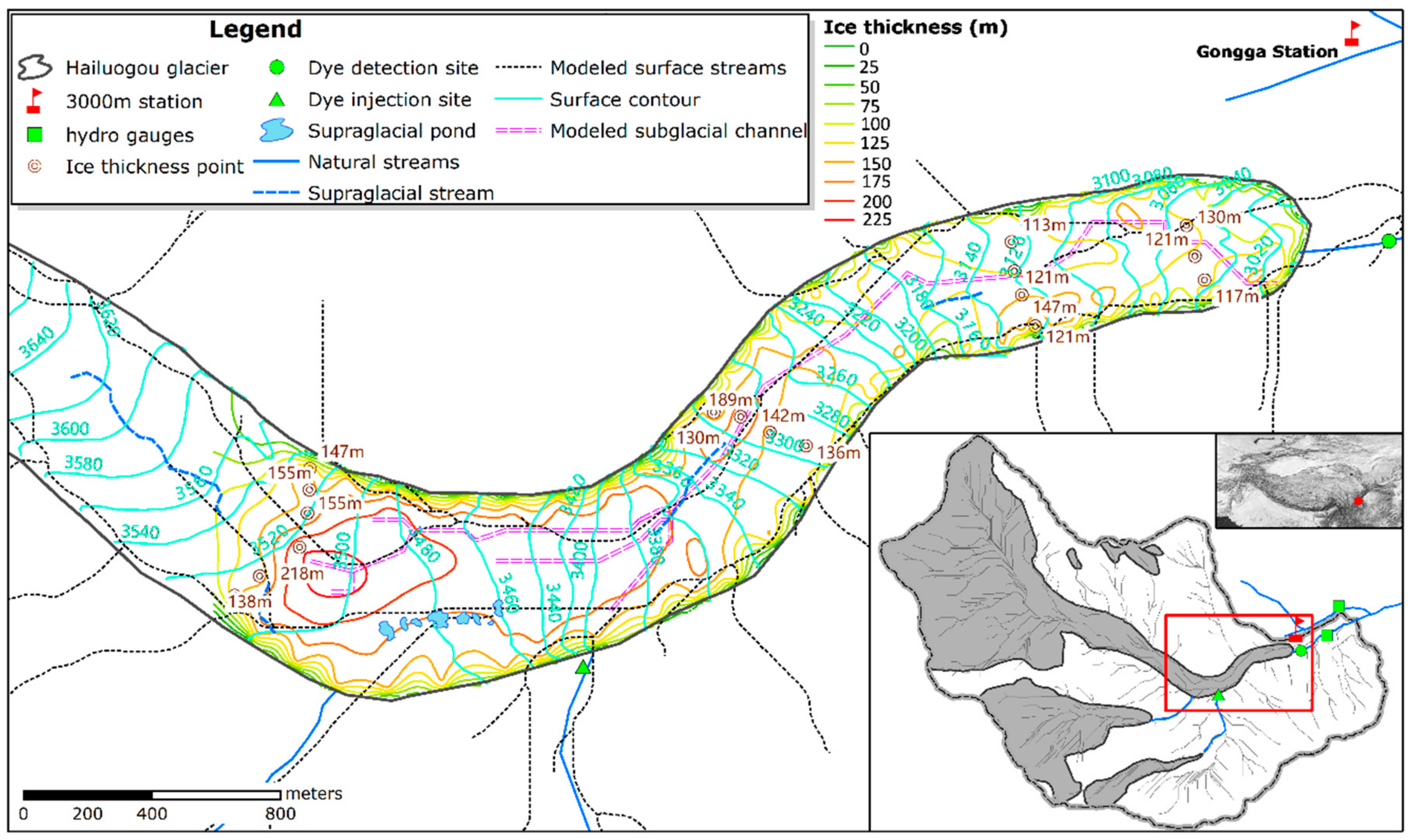
The HLG is a typical monsoonal temperate glacier in Western China [36,37] located on the east slope of Mount Gongga (29°35.6′ N, 101°56.7′ E), a massif lying in the Center Hengduan Mountains on the south-eastern edge of the Tibetan Plateau (Figure 1). It extends about 13 km in length and 24.7 km2 in area, with altitudes ranging from 2990 m to 7556 m above sea level (a.s.l.). The HLG has a broad accumulation basin and the glacier surface area reaches its maximum extent at about 5400 m a.s.l. Six small hanging or valley glaciers are distributed in both the northern and southern slopes of the HLG basin (Figure 1). Melt streams from these tributary glaciers enter the base of Hailuogou lacier tongue via its margin. The biggest two tributaries, which are fed by glaciers No. 2 and No. 3 located on the right side of the catchment, flow directly beneath the terminus tongue of the Hailuogou Glacier.
The ice tongue of the HLG including a 1080 m high ice fall (3700 m to 4800 m a.s.l.) at its upper part, wriggle down along the valley with a total length of about 5 km (Figure 1). According to the remote sensing observations and repeated ice surface elevation surveys, the ice tongue of the Hailuogou Glacier has experienced continuous and remarkable shrinkage during the past 40 years. Its front position has retreated by about 1878 m since 1930 and its surface area has decreased by 3.5% from 1966 to 2007 [33]. Strong and accelerated ice thinning has been observed in recent years (mean ice surface elevation decreased at a rate of 1.1 ± 0.4 m a−1 between 1966 and 2009) [38].
The lower area of the ice tongue is generally covered by a debris layer that increases in thickness downglacier and reaches about 1.5 m near the terminus [39] (Figure 2). During the earlier ablation season (April to early May), supraglacial lakes or water ponded by crevasses can be generally found in the region of relative flat ice surfaces between 3500 m and 3600 m a.s.l. These ponded water bodies or small supraglacial lakes (~159.5 to 1993.7 m2 in area in 2009 shown in Figure 1) usually have short-term survival cycles and can completely drain during the deep summer [40] with the increase of glacier velocity or probably due to the establishment of englacial and subglacial hydraulic connections.
3. Data and Methods
3.1. Hydro-Meteorological Observation and Dye Injections
Data from the Gongga Mountain Station (GGS), located at 3000 m a.s.l. nearby the Hailuogou Glacier (Luding, China) (Figure 1), were used to demonstrate the meteorological and hydrological conditions in the HLG catchment. During the period 1988–2005, the observed mean annual temperature at 3000 m a.s.l. was 4.1 °C and the maximum and minimum daily records were 23.2 °C and −14.0 °C, respectively. Rain gauge recorded an annual average of 251 days with precipitation with a mean annual amount of 1942 mm, of which ~87% was concentrated in the ablation seasons (April to October) and ~44% was concentrated in summer (July to September).
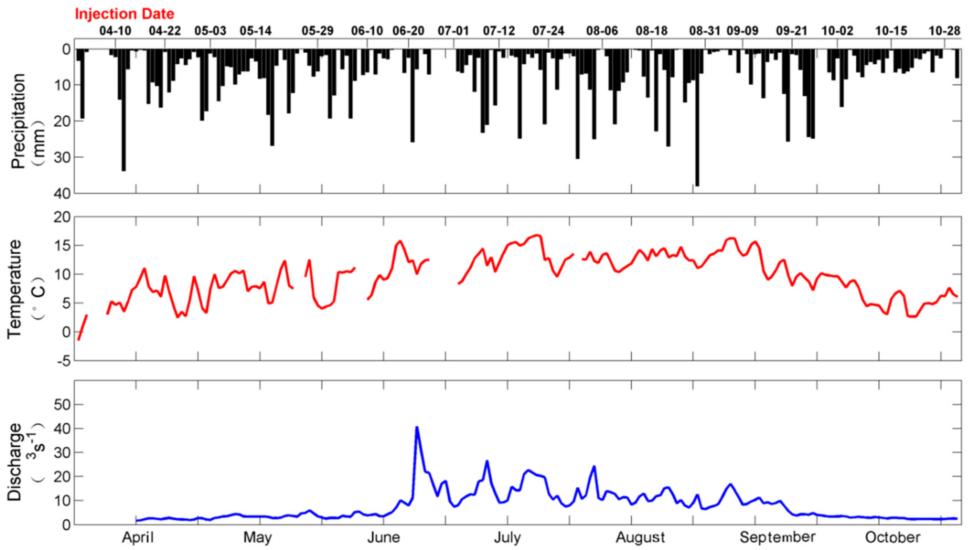
During the 2009 ablation season (1 April to 31 October), air temperature at 3000 m a.s.l. varied between −1.5 °C and 16.8 °C with an average value of 9.6 °C (Figure 3). This was a relative warm ablation season compared to the multi-year average mean (8.6 °C) for air temperature between April and October, and the amplitude of temperature variations in 2009 was larger than average (between 1.8 °C and 13.7 °C). Total precipitation over the 2009 ablation season was 1334.4 mm, which was lower than the average (1705.4 mm). Precipitation was concentrated between July and September but was also high earlier around May, with the maximum daily precipitation (38 mm) occurring on 29 August (year day 241).
Hourly discharge of the glacial melt stream has been routinely monitored since 1994 by a hydro-gauge station located about 900 m downstream of the glacier terminal (Figure 1). The discharge of the stream was determined by the velocity-area method where the flow velocity was measured twice in each year using a current meter at 1 m intervals across the river. The relationship between discharge and a separated auto-recorded water level was constructed to calculate the hourly stream flow. The 2009 runoff of the HLG basin was characterized by a remarkable glacier outburst flood (with the daily discharge 40.9 m3 s−1) that occurred earlier in the ablation season (on 22 June) before fluctuating in abundant runoff yield, but in less flood volume through the summer (Figure 3). Before the June outburst and after the end of September, the runoff maintained at a base flow level with a daily discharge less than 3 m3 s−1.
3.2. Dye-Tracing Experiments and Tracer Transport Model
We used Rhodamine-WT as the tracer and its recovery concentration downstream was measured using an Aquafluor Handheld fluorometer with one fluorescence channel (with a detection accuracy of 0.4 ppb). The injection site was located at the entrance of the melt stream from Hailuogou Glacier No. 1 at 3400 m a.s.l. (Figure 1 and Figure 2), which is about 2.5 km of drainage flow distance to the outlet of the subglacial channel. No additional sites were selected for our tracer experiments as no stable moulin or crevasse could survive for the whole ablation season.
To determine the amount of tracer used for injection and the starting time to monitor the recovery at the outlet of the glacier terminal, several pre-tests together with modeling analysis [23] before the regular experiment were carried out earlier in April. An amount of 1 L of 20% solution (~200 mg) Rhodamine-WT was found to be a suitable injection for this 2.5 km distance and the condition of multi-year mean runoff discharge of 11.53 m3 s−1, and generally after about 0.5 h since injections of Rhodamine-WT in the stream could be detected by the Aquafluor meter. All injections were made between 08:00 and 09:00 in the morning of the day if there was no precipitation or only light rain (daily precipitation < 5 mm) occurred. The recovered sampling site was located at the outlet of the subglacial channel; ~10 m from the ice edge (Figure 1). Samples were taken at 5 min intervals for a period of ~8 h from the time of tracer injection. Tracing experiments were repeatedly conducted between 10 April and 28 October 2009 with an interval of about 10 days. The day of the 18 tracer experiments are indicated in the upper part of Figure 3.
A one-dimensional tracer transport model, the advection-dispersion model (ADM) following Schuler et al. [23], was used to derive the transport parameters from the tracer experiments. For each individual tracer experiment, the recovered tracer concentration c as a function of time t since injection is given by:
where Q is the discharge of the stream (use the daily mean discharge by assuming a constant value for the duration of each experiment); x is the distance of the tracer movement; v is the tracer transit velocity; and m is the amount of injection. Given v as the mean tracer transit velocity averaged spatially over the length of the flow path, it could be derived from the transit distance x and recovery time Tr (time of the peak concentration detected for Rhodamine-WT), that is v = x/Tr; Equation (1) could be solved for the dispersion coefficient D, which parameterizes the hydrodynamic dispersion of the tracer and serves as an indication of the variability for subglacial drainage system hydraulics.
The extent and complexity of the subglacial drainage system could be indicated by the degree of dispersion, d = D/v. For each individual experiment, we simulated the TRC based on the ADM transport model.
4. Results and Discussion
4.1. Subglacial Drainage System Characteristic Indicated by Dye Tracing Experiment
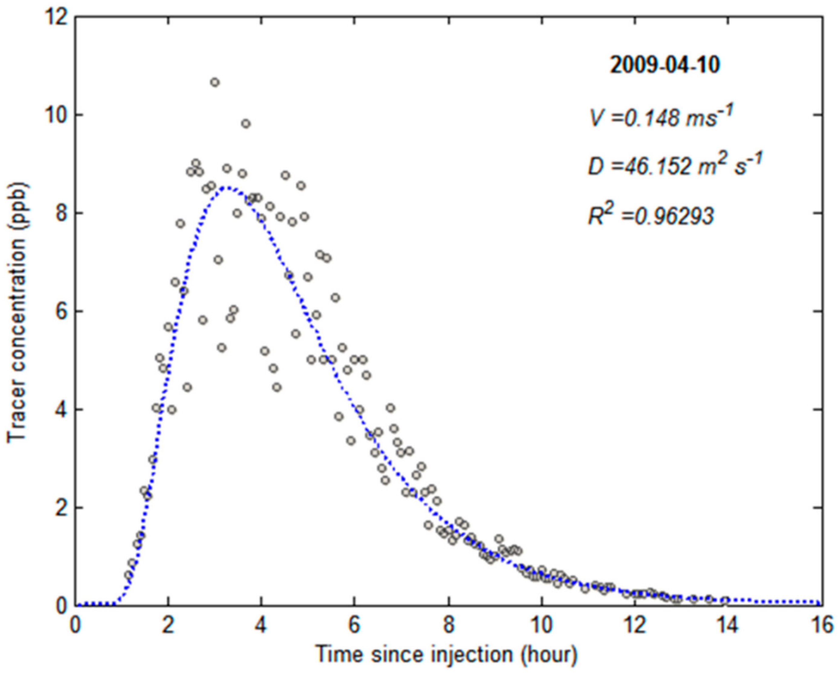
Since we only had one injection site, our results could only indicate the hydraulic dynamics of the subglacial channel in the lowest part of the ice tongue. Figure 4 shows an example of the modeling result of an experiment carried out on 10 April 2009 where the mean tracer transit velocity (v) and dispersion coefficient (D) were noted. The shapes of TRCs were similar for all injections during the 2009 ablation seasons, which were characterized by a single but asymmetrical peaked curve, with a faster increase in the dye concentration before the peak and slower recession after the peak. The highly one-peaked shape of the TRCs indicated that the drainage system examined by our tracing experiments was a stable and simple subglacial channel with limited tributary/branches, which could usually lead to a multi-peak of TRC [26]. This coincided with our modeling result of the shape of the subglacial drainage networks using the hydraulic potential calculation (Figure 1). The dye-investigated section of the subglacial channel could exist all around year due to the uninterrupted water inflow from one of the larger tributary streams fed by two glaciers on the south side of the catchment. Since the ice flow of the lower ablation area of the Hailuogou Glacier is constrained by the lateral terrains and the ice tongue extends longitudinally along the valley trough with a width less than 400 m, the subglacial drainage network is therefore limited longitudinally and without much development of lateral dendritic tributaries as those reported for glaciers with a wider ablation area [20,26,41,42].
All measured tracer concentrations reached the highest detected value (3.08 to 10.65 μg·L−1) in less than 3 h (0.57 to 3.00 h) and receded back to the background value (<0.1 μg·L−1) in about 5 to 10 h after injection. Mean tracer transit velocity over the whole ablation season was 0.294 m/s and varied between 0.148 m/s (10 April) and 0.555 m/s (1 July). The maximum and minimum velocities we observed here were within the ranges of previous reported experiments carried out at other temperate glaciers [19,20,26,41,43].
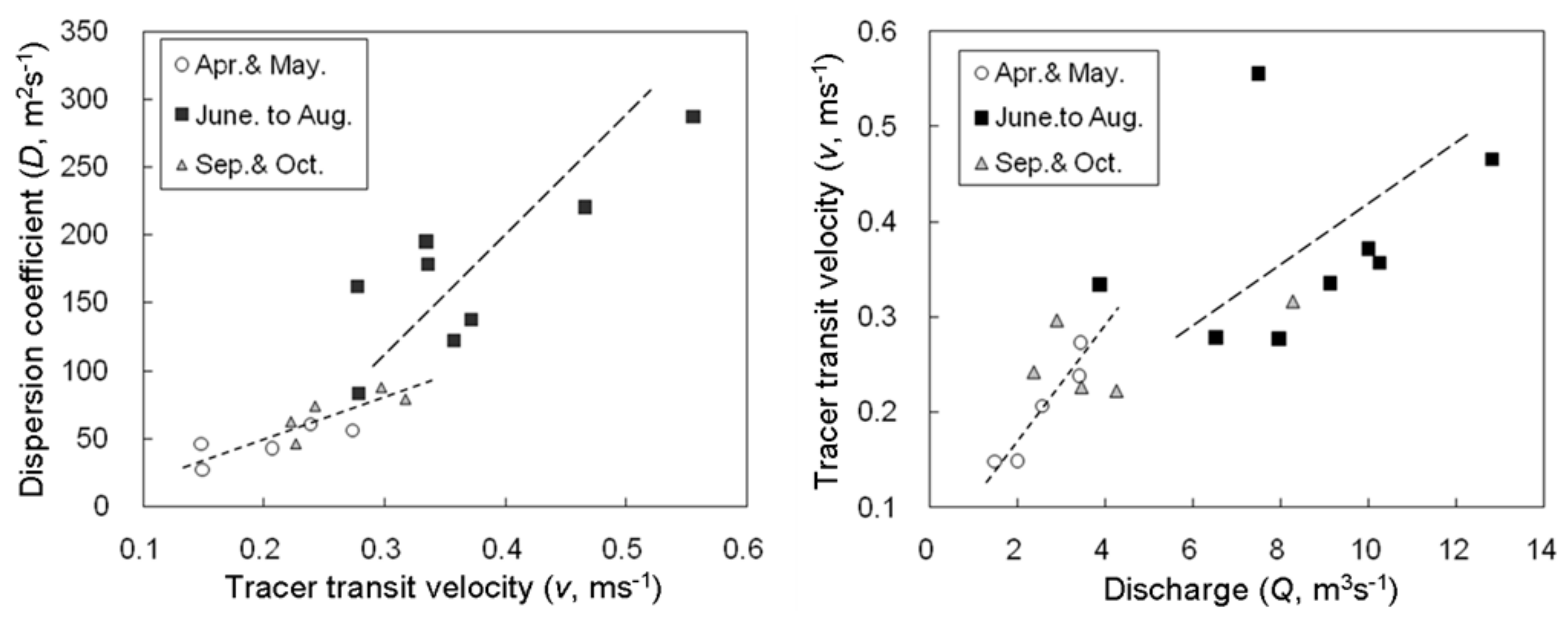
Temporal variation of tracer velocities indicated that a transition of a relative slow–fast–slow drainage system occurred through the ablation seasons. However, this could either be as a result of varying discharge or dynamic drainage efficiency. The Rhodamine-WT peak concentrations were much higher during both the beginning and end of the ablation seasons than in the middle of the ablation season, indicating the strong impact of the varying discharge on the dye’s concentration. Relationships between the tracer transit velocity and dispersion coefficient or discharge were therefore introduced to indicate seasonal changes of subglacial hydraulic efficiency [23,44] since the size and resistance of the drainage system can result in a changing slope of the v-D and v-Q relationships (Figure 5). Regression slope of the v-D and v-Q indicated that a more dispersive (larger) drainage system developed during the middle ablation season (June to August) than in the earlier and later ablation seasons (April to May and September to October). Previous hydrological process analysis [40] on seasonal dynamics of discharge-air temperature time lags has indicated that the drainage efficiency of the Hailuogou Glacier catchment showed high variability during the ablation season. However, the persistent subglacial channel system we argued in this study does not mean that the drainage system is not variable. Our tracer experiments through one ablation season indicated that the subglacial channel existed as a persistent channel system, but the drainage efficiency changed through time.
4.2. Seasonal Evolution of Subglacial Drainage System
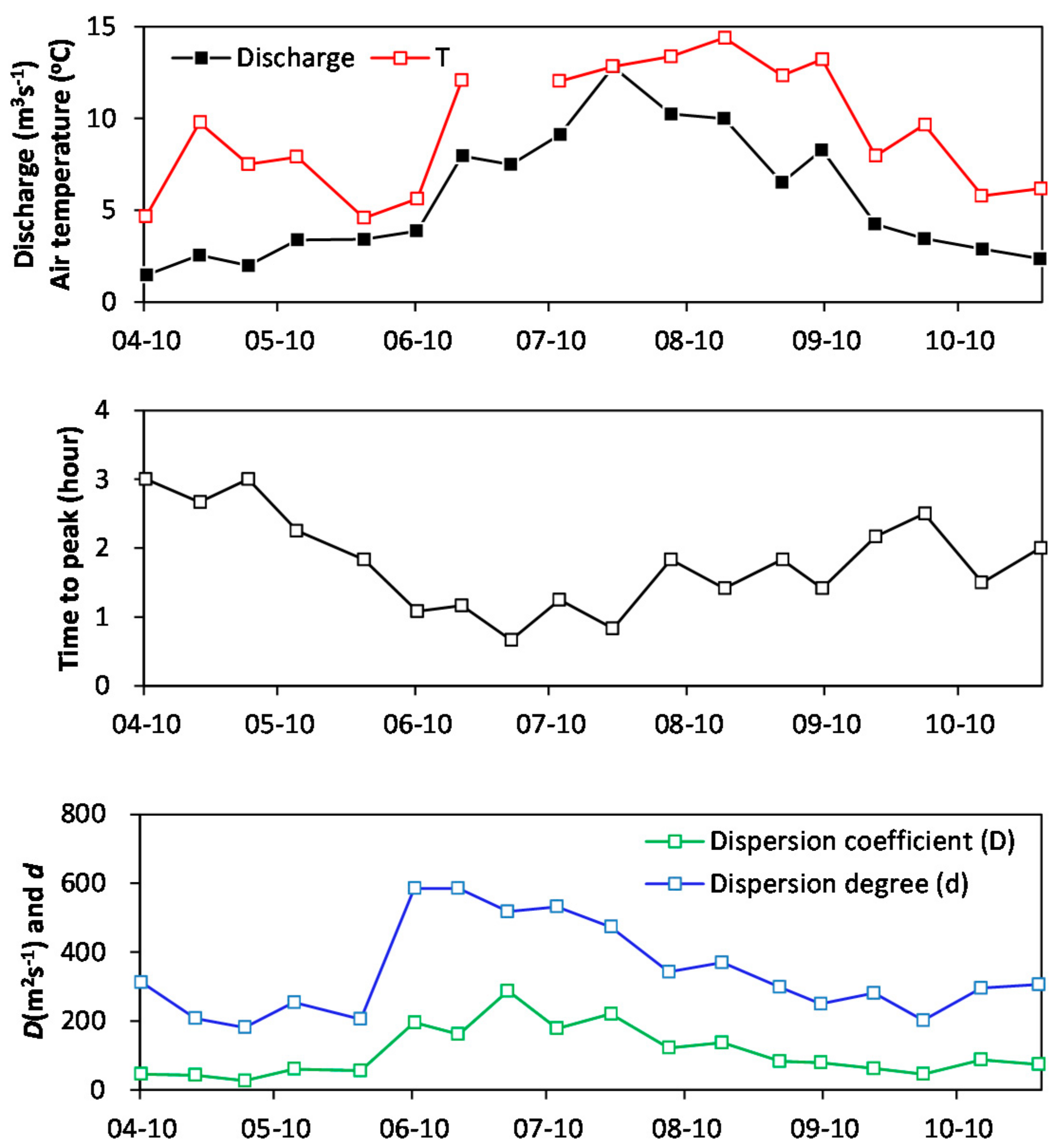
The structure of the subglacial drainage system was strongly affected by subglacial water pressure distribution and conditions, which were directly impacted by changes of overburden ice thickness. Although we only selected one site for the dye injection, seasonal changes of the dye tracing experiments indexes indicated that during the whole ablation season, a transition of low–high–low hydraulic efficiency of the subglacial drainage system occurred for the investigated lower part of the Hailougou Glacier tongue (Figure 6). The time of the detected dye peak concentration gradually decreased from ~3 h during the earlier ablation seasons to ~1 h during the middle ablation seasons (June and July) and increased again during the later ablation seasons, indicating that this section of subglacial channel was likely to experience expansion with a higher drainage efficiency in middle summer than in the earlier and later ablation seasons.
Increasing air temperature was the primary contribution factor to the changes in the subglacial system from an inefficient to an efficient one. Inflow water can bring convective heat from the surface to the subglacial and melts the ice at the ice–water interface [45], leading to subglacial channel expansion. The channel became larger/wider as the ablation season progressed and more meltwater entered the system until a fast drainage system was developed in the middle summer. Expansion of the subglacial channel is also a self-adaption to the increasing catchment discharge, which is controlled by concentrated precipitation and enhanced ice melt simultaneously occurring in summer [33]. Since the subglacial channel we diagnosed was a simple longitudinal channel with limited tributary/branches, its relative size (mean cross section area) could also be inferred from the variation of the dispersion degree of the dye tracer (Figure 6). A remarkable increase of dispersion degree that occurred at the end of May or the beginning of June coincided with the sharp increase of air temperature and proglacial discharge.
4.3. Implications for Downstream Environments
Understanding the glacial hydrological process as well as the catchment sediment yields which are closely related to the subglacial drainage system evolutions are important to implicate their impact on the downstream infrastructures. Seasonal changes of drainage system will influence the glacial runoff process, i.e., abrupt release of subglacial stored water may lead to flash floods downstream [46]. The high erosion/weathering rate of mountain glaciers can produce remarkable sediment downstream and can thus influence the operation and lifetime of the electric power stations relying on the glacial melt water [47].
Melt streams from Mt. Gongga glaciers flow into the Dadu River, where recently cascaded dams have been constructed for electric power generation [48]. The closest dam is the Dagangshan Hydropower Station (2600 MW, 7.42 × 10⁹ m3), which is ~35 km downstream from Mt. Gongga. Glacier dynamics in Mt. Gongga will impact downstream hydropower stations either by their changing glacial runoff or by their varying sediment yields from the glacierized areas. The character of glacier drainage systems indicated by our tracer experiments should be addressed in future glacial runoff modeling since the drainage channel is likely to exist year-round but with varying drainage efficiency. The glacier drainage system in the lower ablation area of the Hailuogou Glacier must accommodate considerable water from the tributary streams, summer precipitation, and ice ablation from itself. Continuous hydraulic erosion from the stable subglacial channel will not only increase the total amount sediment yield from the Hailuogou catchment, but also decrease the duration time of sediment retention in the glacial system. The next step of monitoring and estimating sediment flux from the Mt. Gongga glaciers is thus important for programing seasonal regulation procedures of the Dagangshan Hydropower Station, since it is the first reservoir for sediment to fall out.
5. Conclusions
With continuous streams fed by its tributaries, the lower tongue of the Hailuogou Glacier is prone to developing a highly efficient subglacial drainage system during the whole ablation season. The longitudinal subglacial channel is also likely to exist in winter, during which we have observed considerable runoff escape subglacially from the glacier terminal. Based on repeated dye tracer experiments at one of the tributaries’ entrance in the middle part the ice tongue, we confirmed that the examined section of glacier was characterized by a fast and stable subglacial drainage system. During summer, to adapt the increased runoff due to enhanced ablation and concentrated liquid precipitation occurring at both the Hailuogou Glacier itself and its tributary catchments, a more efficient drainage system was developed as indicated by our tracer transport model. Since a long-standing but variable subglacial drainage system of temperate glacier can impact local ice flow, subglacial ablation, and in some cases, ice collapse thus ice cliff formation, in future we should focus on how the variability of the subglacial drainage system influences the stability and dynamics of the glacier ablation area and what roles the tributary streams play in this process.
Author Contributions
Conceptualization, Q.L.; Methodology, Q.L.; Software, Q.L.; Validation, S.L. and Q.L.; Investigation, Q.L.; Resources, Q.L. and W.C.; Data Curation, Q.L.; Writing-Original Draft Preparation, Q.L.; Writing-Review & Editing, S.L.; Visualization, Q.L.; Supervision, S.L.; Project Administration, Q.L. and S.L.; Funding Acquisition, Q.L.
Funding
This research was funded by the National Natural Science Foundation of China grant numbers 41371094 and 40801030.
Acknowledgments
We thank the Gongga Alpine Ecosystem Observation and Research Station for the hydro-climatic data collection and field assistance.
Conflicts of Interest
The authors declare no conflict of interest.
References
- Hewitt, I.J. Seasonal changes in ice sheet motion due to melt water lubrication. Earth Planet. Sci. Lett. 2013, 317–312, 16–25. [Google Scholar] [CrossRef]
- Baker, N. The Influence of Subglacial Hydrology on the Flow of West Antarctic Ice Streams. Doctoral Thesis, University of Cambridge, Cambridge, UK, 2012. [Google Scholar]
- Sugiyama, S.; Skvarca, P.; Naito, N.; Enomoto, H.; Tsutaki, S.; Tone, K.; Marinsek, S.; Aniya, M. Ice speed of a calving glacier modulated by small fluctuations in basal water pressure. Nat. Geosci. 2011, 4, 597–600. [Google Scholar] [CrossRef] [Green Version]
- Bingham, R.G.; Hubbard, A.L.; Nienow, P.W.; Sharp, M.J. An investigation into the mechanisms controlling seasonal speedup events at a High Arctic glacier. J. Geophys. Res. Earth Surf. 2008, 113. [Google Scholar] [CrossRef] [Green Version]
- Anderson, R.S. Strong feedbacks between hydrology and sliding of a small alpine glacier. J. Geophys. Res. Earth Surf. 2004, 109. [Google Scholar] [CrossRef] [Green Version]
- Zwally, H.J.; Abdalati, W.; Herring, T.; Larson, K.; Saba, J.; Steffen, K. Surface melt-induced acceleration of Greenland ice-sheet flow. Science 2002, 297, 218–222. [Google Scholar] [CrossRef] [PubMed]
- Schoof, C. Ice-sheet acceleration driven by melt supply variability. Nature 2010, 468, 803–806. [Google Scholar] [CrossRef] [PubMed]
- Sundal, A.V.; Shepherd, A.; Nienow, P.; Hanna, E.; Palmer, S.; Huybrechts, P. Melt-induced speed-up of Greenland ice sheet offset by efficient subglacial drainage. Nature 2011, 469, 521–524. [Google Scholar] [CrossRef] [PubMed]
- Iken, A.; Bindschadler, R.A. Combined Measurements of Subglacial Water-Pressure and Surface Velocity of Findelengletscher, Switzerland-Conclusions About Drainage System and Sliding Mechanism. J. Glaciol. 1986, 32, 101–119. [Google Scholar] [CrossRef]
- Iken, A.; Truffer, M. The relationship between subglacial water pressure and velocity of Findelengletscher, Switzerland, during its advance and retreat. J. Glaciol. 1997, 43, 328–338. [Google Scholar] [CrossRef] [Green Version]
- Bartholomaus, T.C.; Anderson, R.S.; Anderson, S.P. Response of glacier basal motion to transient water storage. Nat. Geosci. 2008, 1, 33–37. [Google Scholar] [CrossRef]
- Fountain, A.G.; Walder, J.S. Water flow through temperate glaciers. Rev. Geophys. 1998, 36, 299–328. [Google Scholar] [CrossRef] [Green Version]
- Wadham, J.L.; Hodgkins, R.; Cooper, R.J.; Tranter, M. Evidence for seasonal subglacial outburst events at a polythermal glacier, Finsterwalderbreen, Svalbard. Hydrol. Process. 2001, 15, 2259–2280. [Google Scholar] [CrossRef]
- Jobard, S.; Dzikowski, M. Evolution of glacial flow and drainage during the ablation season. J. Hydrol. 2006, 330, 663–671. [Google Scholar] [CrossRef]
- Flowers, G.E. Subglacial modulation of the hydrograph from glacierized basins. Hydrol. Process. 2008, 22, 3903–3918. [Google Scholar] [CrossRef]
- Brown, G.H.; Sharp, M.; Tranter, M. Subglacial chemical erosion: Seasonal variations in solute provenance, Haut Glacier d’Arolla, Valais, Switzerland. Ann. Glaciol. 1996, 22, 25–31. [Google Scholar] [CrossRef]
- Riihimaki, C.A.; MacGregor, K.R.; Anderson, R.S.; Anderson, S.P.; Loso, M.G. Sediment evacuation and glacial erosion rates at a small alpine glacier. J. Geophys. Res. Earth Surf. 2005, 110. [Google Scholar] [CrossRef] [Green Version]
- Anderson, S.P.; Longacre, S.A.; Kraal, E.R. Patterns of water chemistry and discharge in the glacier-fed Kennicott River, Alaska: Evidence for subglacial water storage cycles. Chem. Geol. 2003, 202, 297–312. [Google Scholar] [CrossRef]
- Nienow, P.; Sharp, M.; Willis, I. Seasonal changes in the morphology of the subglacial drainage system, Hautglacier d’Arolla, Switzerland. Earth Surf. Process. Landf. 1998, 23, 825–843. [Google Scholar] [CrossRef]
- Willis, I.; Lawson, W.; Owens, I.; Jacobel, B.; Autridge, J. Subglacial drainage system structure and morphology of Brewster Glacier, New Zealand. Hydrol. Process. 2009, 23, 384–396. [Google Scholar] [CrossRef]
- Fountain, A.G. Geometry and Flow Conditions of Subglacial Water at South Cascade Glacier, Washington-State, USA—An Analysis of Tracer Injections. J. Glaciol. 1993, 39, 143–156. [Google Scholar] [CrossRef]
- Nienow, P.W.; Sharp, M.; Willis, I.C. Velocity-discharge relationships derived from dye tracer experiments in glacial meltwaters: Implications for subglacial flow conditions. Hydrol. Process. 1996, 10, 1411–1426. [Google Scholar] [CrossRef]
- Schuler, T.; Fischer, U.H.; Gudmundsson, G.H. Diurnal variability of subglacial drainage conditions as revealed by tracer experiments. J. Geophys. Res. 2004, 109. [Google Scholar] [CrossRef] [Green Version]
- Bingham, R.G.; Nienow, P.W.; Sharp, M.J.; Boon, S. Subglacial drainage processes at a High Arctic polythermal valley glacier. J. Glaciol. 2005, 51, 15–24. [Google Scholar] [CrossRef] [Green Version]
- Chandler, D.M.; Wadham, J.L.; Lis, G.P.; Cowton, T.; Sole, A.; Bartholomew, I.; Telling, J.; Nienow, P.; Bagshaw, E.B.; Mair, D.; et al. Evolution of the subglacial drainage system beneath the Greenland Ice Sheet revealed by tracers. Nat. Geosci. 2013, 6, 195–198. [Google Scholar] [CrossRef]
- Willis, I.C.; Fitzsimmons, C.D.; Melvold, K.; Andreassen, L.M.; Giesen, R.H. Structure, morphology and water flux of a subglacial drainage system, Midtdalsbreen, Norway. Hydrol. Process. 2011. [Google Scholar] [CrossRef]
- Divine, C.E.; McDonnell, J.J. The future of applied tracers in hydrogeology. Hydrogeol. J. 2005, 13, 255–258. [Google Scholar] [CrossRef] [Green Version]
- Hannah, D.M.; Angela, M.G.; McGregor, G.R. A methodology for investigation of the seasonal evolution in proglacial hydrograph form. Hydrol. Process. 1999, 13, 2603–2621. [Google Scholar] [CrossRef]
- Hannah, D.M.; Smith, B.P.G.; Gurnell, A.M.; McGregor, G.R. An approach to hydrograph classification. Hydrol. Process. 2000, 14, 317–338. [Google Scholar] [CrossRef]
- Su, Z.; Shi, Y. Response of monsoonal temperate glaciers to global warming since the Little Ice Age. Quat. Int. 2002, 97–98, 123–131. [Google Scholar] [CrossRef]
- Shi, Y.; Hsieh, T.-C.; Cheng, P.-H.; Li, C.-C. Distribution, features and variations of glaciers in China in World Glacier Inventory—Inventaire mondial des Glacie. In Proceedings of the Riederalp Workshop, Riederalp, Switzerland, 17–22 September 1978. [Google Scholar]
- Aizen, V.B.; Aizen, H.M. Regime and Mass-Energy Exchange of Subtropical Latitude Glaciers under Monsoon Climatic Conditions: Gongga Shan, Sichuan, China. Mt. Res. Dev. 1994, 14, 101–118. [Google Scholar] [CrossRef]
- Liu, Q.; Liu, S.; Zhang, Y.; Wang, X.; Zhang, Y.; Guo, W.; Xu, J. Recent shrinkage and hydrological response of Hailuogou glacier, a monsoon temperate glacier on the east slope of Mount Gongga, China. J. Glaciol. 2010, 56, 215–224. [Google Scholar] [CrossRef]
- Benn, D.; Bolch, T.; Hands, K.; Gulley, J.; Luckman, A.; Nicholson, L.I.; Quincey, D.; Thompson, S.; Toumi, R.; Wiseman, S. Response of debris-covered glaciers in the Mount Everest region to recent warming, and implications for outburst flood hazards. Earth-Sci. Rev. 2012, 114, 156–174. [Google Scholar] [CrossRef] [Green Version]
- Lu, R.; Gao, S. Debris Flow in the Ice Tongue Area of Hailuogou Glacier on the Eastern Slope of Mt. Gongga. J. Glaciol. Geocryol. 1992, 1, 8. [Google Scholar]
- He, Y.; Zhang, Z.; Theakstone, W.H.; Chen, T.; Yao, T.; Pang, H. Changing features of the climate and glaciers in China’s monsoonal temperate glacier region. J. Geophys. Res. 2003, 108, 4530–4536. [Google Scholar] [CrossRef]
- Shi, Y. Concise Glacier Inventory of China; Shanghai Popular Science Press: Shanghai, China, 2008. [Google Scholar]
- Pan, B.T.; Zhang, G.L.; Wang, J.; Cao, B.; Geng, H.P.; Wang, J.; Zhang, C.; Ji, Y.P. Glacier changes from 1966–2009 in the Gongga Mountains, on the south-eastern margin of the Qinghai-Tibetan Plateau and their climatic forcing. Cryosphere 2012, 6, 1087–2012. [Google Scholar] [CrossRef]
- Zhang, Y.; Fujita, K.; Liu, S.; Liu, Q.; Nuimura, T. Distribution of debris thickness and its effect on ice melt at Hailuogou glacier, southeastern Tibetan Plateau, using in situ surveys and ASTER imagery. J. Glaciol. 2011, 57, 1147–1157. [Google Scholar] [CrossRef]
- Liu, Q.; Liu, S. Seasonal evolution of the englacial and subglacial drainage systems of a temperate glacier revealed by hydrological analysis. Sci. Cold Arid. Reg. 2010, 2, 51–58. [Google Scholar]
- Hock, R.; Hooke, R.L. Evolution of the internal drainage system in the lower part of the ablation area of Storglaciaren, Sweden. Geol. Soc. Am. Bull. 1993, 105, 537–546. [Google Scholar] [CrossRef]
- Sharp, M.; Richards, K.; Willis, I.; Arnold, N.; Nienow, P.; Lawson, W.; Tison, J.-L. Geometry, bed topography and drainage system structure of the Haut Glacier Darolla, Switzerland. Earth Surf. Process. Landf. 1993, 18, 557–571. [Google Scholar] [CrossRef]
- Hock, R.; Iken, A.; Wangler, A. Tracer experiments and borehole observations in the overdeepening of Aletschgletscher, Switzerland. Ann. Glaciol. 1999, 28, 253–260. [Google Scholar] [CrossRef]
- Seaberg, S.Z.; Seaberg, J.Z.; Hooke, R.L.; Wiberg, D.W. Character of the Englacial and Subglacial Drainage System in the Lower Part of the Ablation Area of Storglaciaren, Sweden, as Revealed by Dye-Trace Studies. J. Glaciol. 1988, 34, 217–227. [Google Scholar] [CrossRef]
- Isenko, E.; Naruse, R.; Mavlyudov, B. Water temperature in englacial and supraglacial channels: Change along the flow and contribution to ice melting on the channel wall. Cold Reg. Sci. Technol. 2005, 42, 53–62. [Google Scholar] [CrossRef]
- Rounce, D.R.; Byers, A.C.; Byers, E.A.; McKinney, D.C. Brief communication: Observations of a glacier outburst flood from Lhotse Glacier, Everest area, Nepal. Cryosphere 2017, 11, 443–449. [Google Scholar] [CrossRef] [Green Version]
- Felix, D.; Albayrak, I.; Abgottspon, A.; Boes, R.M. Optimization of hydropower plants with respect to fine sediment focusing on turbine switch-offs during floods. IOP Conf. Ser. Earth Environ. Sci. 2016, 49, 1211–1220. [Google Scholar] [CrossRef]
- Mozigou Glacier Meltwater Pays High Hydropower Dividend. Available online: https://blogs.agu.org/fromaglaciersperspective/2018/07/11/mozigou-glacier-meltwater-pays-high-hydropower-dividend/ (accessed on 23 July 2018).
Figure 1.
Map of the lower part ice tongue of the Hailuogou Glacier overlapped with ice surface contour, interpolated ice thickness distribution based on point measurements, observed supraglacial streams and ponds, and theoretical (modeled) networks of surface streams and subglacial channel; inset maps showing the Hailuogou catchment and the location of the study area.

Figure 2.
The upper ablation area of the Hailuogou Glacier before (a, October 2008) and after (b, April 2009) the supraglacial water ponded. Locations of three larger ponds are marked by red arrows.
Figure 2.
The upper ablation area of the Hailuogou Glacier before (a, October 2008) and after (b, April 2009) the supraglacial water ponded. Locations of three larger ponds are marked by red arrows.

Figure 3.
Daily precipitation, air temperature, and discharge between 1 April and 31 October 2009 recorded by GGS. Injection dates of dye tracer experiments are marked on the top.
Figure 3.
Daily precipitation, air temperature, and discharge between 1 April and 31 October 2009 recorded by GGS. Injection dates of dye tracer experiments are marked on the top.

Figure 4.
An example of observed (black circles) and modeled (blue line) return curve for a tracer experiment on 10 April 2009.
Figure 4.
An example of observed (black circles) and modeled (blue line) return curve for a tracer experiment on 10 April 2009.

Figure 5.
Velocity-dispersion (left) and velocity-discharge relationships (right) indicated seasonal changes of subglacial hydraulic efficiency (dashed line: Different melt periods were grouped to draw the slope of linear regression of v-D and v-Q).
Figure 5.
Velocity-dispersion (left) and velocity-discharge relationships (right) indicated seasonal changes of subglacial hydraulic efficiency (dashed line: Different melt periods were grouped to draw the slope of linear regression of v-D and v-Q).

Figure 6.
Comparison between daily mean air temperature, proglacial discharge, time to tracer peak concentration, and dye dispersion.
Figure 6.
Comparison between daily mean air temperature, proglacial discharge, time to tracer peak concentration, and dye dispersion.

© 2018 by the authors. Licensee MDPI, Basel, Switzerland. This article is an open access article distributed under the terms and conditions of the Creative Commons Attribution (CC BY) license (http://creativecommons.org/licenses/by/4.0/).
Share and Cite
MDPI and ACS Style
Liu, Q.; Liu, S.; Cao, W. Seasonal Variation of Drainage System in the Lower Ablation Area of a Monsoonal Temperate Debris-Covered Glacier in Mt. Gongga, South-Eastern Tibet. Water 2018, 10, 1050. https://doi.org/10.3390/w10081050
AMA Style
Liu Q, Liu S, Cao W. Seasonal Variation of Drainage System in the Lower Ablation Area of a Monsoonal Temperate Debris-Covered Glacier in Mt. Gongga, South-Eastern Tibet. Water. 2018; 10(8):1050. https://doi.org/10.3390/w10081050
Chicago/Turabian StyleLiu, Qiao, Shiyin Liu, and Wulong Cao. 2018. "Seasonal Variation of Drainage System in the Lower Ablation Area of a Monsoonal Temperate Debris-Covered Glacier in Mt. Gongga, South-Eastern Tibet" Water 10, no. 8: 1050. https://doi.org/10.3390/w10081050
Note that from the first issue of 2016, this journal uses article numbers instead of page numbers. See further details here.