Article

Water Compensation and Its Implication of the Three Gorges Reservoir for the River-Lake System in the Middle Yangtze River, China

1
College of Resources and Environmental Science, South-Central University for Nationalities, Wuhan 430074, China
2
Department of Civil & Environmental Engineering, University of Alberta, Edmonton, AB T6G 2W2, Canada
3
College of Hydropower & Information Engineering, Huazhong University of Science & Technology, Wuhan 430074, China
4
China Institute of Water Resources and Hydropower Research, Beijing 100038, China
5
Bureau of Hydrology, Changjiang Water Resources Commission, Wuhan 430010, China
6
Changjiang River Scientific Research Institute, Wuhan 430010, China
7
Tianjin Research Institute for Water Transport Engineering, Tianjin 300456, China
*
Author to whom correspondence should be addressed.
Water 2018, 10(8), 1011; https://doi.org/10.3390/w10081011
Submission received: 29 May 2018 / Revised: 17 July 2018 / Accepted: 25 July 2018 / Published: 31 July 2018
(This article belongs to the Section Hydrology)

Abstract

:
Dam construction is an important means to improve water use efficiency and the aquatic environment. However, the flow regulation of the Three Gorges Reservoir (TGR) in the middle Yangtze River has attracted much attention because the severe drought occurred in the river-lake system downstream of the TGR. In this paper, the Dongting Lake was selected as a case study in order to detect the possible relationship between the flow regulation of the TGR and the extreme drought in the river-lake system based on a coupled hydrodynamic model. The results not only confirmed the significant role of the TGR to relieve drought in the river-lake system, but also indicated that the outflow of the TGR and the hydraulic gradient between the Zhicheng to Chenglingji stations were the crucial factors to affect the water exchange between the rivers and the Dongting Lake. The adjustment of hydraulic gradient within a proper range during the water compensation of the TGR will be an effective measure to improve the water exchange and water environment in the river-lake system. These findings present the quantitative influence of these important factors on the water exchange between rivers and lakes and provide a scientific reference for environmental and ecological management of other river-lake systems.

1. Introduction

With the rapid development of social economy, the exploitation and utilization of water resources of rivers and lakes have been highly concerned around the world [1,2,3]. In particular, dams have been playing an increasingly important role in the integrated utilization of water resources. The Itaipu dam in the Parana River provides 17.4% and 74.1% electrical energy for Brazil and Paraguay, respectively [4]. The Aswan dam in the Nile River not only provides flood protection and electrical energy, but it also supplies adequate water for irrigation [5]. The vast Mead Lake was formed after the construction of Hoover dam in the Colorado River, which has been an important habitat for animals [6]. However, the widespread dams in the world also caused some trouble in the environmental management. Subsequent changes in the timing and duration of streamflow were involved when dams were put into operation [7,8,9]. Consequently, the original ecological balance was partially or fully disrupted in the river basins [10,11,12,13].
The Yangtze River, which is located in the central China, is not excluded from the influence of water resources development. The impoundment impact of the Three Gorges reservoir on hydrology, climate, environment, and ecology has attracted much attention [14,15]. There are obvious hydrological regime changes in the Yangtze River after the operation of the Three Gorges Reservoir (TGR), which have an extensive influence on the health of the river-lake system [16,17]. Water level drop occurs downstream the TGR due to the severe riverbed erosion [18]. Therefore, the water exchange between the rivers and the lakes in the middle Yangtze River is disturbed, which greatly affects the wetland environment that is the main habitat of aquatic plants and animals [19]. The Yangtze River is divided into channel segments by a cascade reservoir system because of the development of water resources, which generally leads to a decrease in biodiversity [20].
In addition, the longer duration of beach exposure in the river-lake system after the operation of the TGR greatly deteriorated the ecological environment [21]. Drought occurred more frequently and its duration increased by about 30% after the operation of the TGR [22]. Therefore, it is undeniable that the environmental impact is remarkable during the impoundment periods. Although the TGR impoundment contributes a lot to the drought in the river-lake system, its contribution to the drought as the main factor remains contentious [23,24,25]. The flow discharge generally increases during the extreme dry seasons from December to the following April, because the water compensation from the TGR is one of the important rules of flow regulation [26]. However, whether the water compensation during the dry seasons can ease the extreme drought of the river-lake system in the middle Yangtze River has not drawn definitive conclusions. Most of the current research is focused on the TGR impoundment and its implication, little work has been performed on the influences of water compensation after the TGR operation on the river-lake system, let alone the research on its mechanism of the water exchange between the mainstream and the lakes [27,28].
Therefore, this paper aims to analyze the real effect of the water compensation from the TGR on the extreme drought in the middle Yangtze River. The Dongting river-lake system was selected as a case study to reveal the impact of water compensation from the TGR based on a one-dimensional/two-dimensional (1D/2D) coupled hydraulic model. Whether the flow regulation of the TGR exacerbated or relieved the extreme drought during the dry seasons was given a definite answer in this study. The variation in water level, flow discharge, and the water exchange between the Dongting Lake and the mainstream was calculated and analyzed. In addition, the influence factors and dynamic mechanism were further discussed. The hydraulic gradient and the outflow from the TGR, as two important factors, were proposed as a first attempt to regulate and control the extreme drought during the dry seasons. The research results can provide some technical support and reference for the administrative departments of water conservancy.

2. Materials and Methods

2.1. Study Area and Data Collection

Dongting Lake, which is located in the middle Yangtze River (111°19′–113°34′ E, 27°39′–29°51′ N), is one of the famous freshwater lakes in the world (Figure 1). The lake area is approximately 2579 km2, accounting for 0.143% of the entire Yangtze basin. The river network around the lake area is the important hydraulic connection between the Dongting Lake and the Yangtze River. Flow diversion occurs from the mainstream of the Yangtze River to the Dongting Lake through the tributaries distributed between the both. There are three flow inlets along the mainstream, as shown in Figure 1, Songzi, Taiping and Ouchi. In addition, four rivers (Li River, Yuan River, Zi River, and Xiang River) pour their water into the Dongting Lake. The flow outlet of the Dongting Lake, Chenglingji, is located at the lowest site of the lake area. All of the rivers and the lake constitute a complex river-lake system in the middle Yangtze River. There are some gauging stations in the study area, which monitored the water level and discharge processes at the key channel sites (Figure 1). The detailed information for these stations is listed in Table 1.
The TGR is located at approximately 45 km upstream of the Yichang hydrological station. Its length and height are 2309 m and 185 m, respectively. According to the operation rules of the TGR, there are four continuous periods of flow regulation within a complete run cycle: (1) flood pre-discharged control, the water in the reservoir is emptied to the downstream before the main flood seasons [28,29]; (2) flood regulation, the upstream floods are regulated and then discharged to the downstream during the periods from July to August [30]; (3) reservoir impoundment, the TGR begins to store water during the approximate periods from September to October; and (4) water compensation, the outflow from the TGR is increased in order to meet the downstream water demand during the dry seasons. The water compensation generally occurred from December to the following April to meet the industrial and agricultural needs and maintain the water depth in the downstream waterways. The TGR was put into operation in 2003 and its impoundment test lasted five years. Impoundment test of the normal pool level was conducted in 2008, and the normal flow regulation of the TGR began since 2009. The inflow and outflow processes of the TGR from 2008 to 2015 are shown in Figure 2. There were the similar regulated flow progresses because of the same strict scheduling rules of the TGR.
In addition, the topographic and hydrological data for the modeling research were collected from the Bureau of Hydrology, Changjiang Water Resources Commission, China. The hydrological data series cover the water level and discharge gauged at the stations in the study area. The topographic maps of the river-lake system were measured from 2008 to 2012. Moreover, the inflow and outflow data after the operation of the TGR from 2008 to 2015 were collected from the Three Gorges Corporation [31].

2.2. Methodologies

2.2.1. Coupled Hydrodynamic Model

1D Hydraulic Model for River Network

The Yangtze River and the tributaries around the Dongting Lake were modeled based on the Mike11 hydrodynamic module [32]. The unsteady flow in rivers was described by the Saint-Venant equations in the hydrodynamic module, as follows:
Q x + B z t = q L
Q x + 2 u Q x + ( g A B u 2 ) z x u 2 A x + g n 2 | u | Q R 4 / 3 = 0
where, t is time; x is the Cartesian coordinate; A is cross-sectional area; Q is flow discharge; q L is the lateral inflow or outflow; z is the water level at cross sections; B is the width of water surface; R is the hydraulic radius; u is mean velocity at a cross section; g is the gravitational acceleration; and, n is bed roughness.

2D Shallow Water Model for the Lake

The 2D shallow-water equations were used to describe the water movement in the lake area based on the Mike 21 hydrodynamic module, as follows [33]:
h t + h U i x i = 0
U i t + U i U i x i = g h x i + f i + τ bi h ρ + A h 2 U i x j 2
in which, i = 1, 2 denotes the x and y directions of the Cartesian coordinate; η is river bed elevation; d is static water depth; h is the total water depth, h = η + d; ρ is the water density; fi is the Coriolis force; Ah is diffusion coefficient of horizontal turbulence; and, τ b i is the bottom friction.

Model Coupling Strategies and Moving Boundary Processing

The 1D and 2D hydrodynamic models were coupled in the frontal zones using the MIKE FLOOD, which is an integrated simulation system [34]. Water changes between the models occurred through the overlapping cross sections, which should be kept conservative and continuous. To complete the water exchange, the inner boundary conditions of the model junctions were calculated, as follows.
In the first place, the stage at the inner boundary sections of the 1D model was assigned the averaged water level at the cell faces of the overlapping cross section:
Z 1 D n + 1 = k = 1 M z 2 D , k S k n + 1 S
where, Z 1 D n + 1 is the boundary stage of the 1D model at the next time step; z 2 D , k n + 1 is the updated stage at the cell faces; s k is the width of cell faces; and, S is the total width of the boundary.
Secondly, the discharge and stage of all the cross sections were calculated by the 1D model, ( Z 1 D n + 1 ,   Q n + 1 ).
Finally, based on the water level of the inner boundary and cell topography, the mean water depth at the cell faces was obtained. Then, the flow velocity ( U k n + 1 ) at each cell face was computed by the Chezy and Manning formula. Then, the stage and velocity at all the 2D mesh points were calculated by the 2D model, ( z 2 D n + 1 ,   U i ).
In addition, discontinuous flow in the rivers and wetland exposure in the lake may occur during the whole hydrological processes. Therefore, to deal with the moving water-land boundary, three controlling water depths were applied in the computation: drying depth ( D d r y ), flooding depth ( D f l o o d ), and wetting depth ( D w e t ) [35,36]. When the water depth in any cell face was smaller than D d r y , the equations would not be solved in the cell face; when the water depth was larger than D w e t , the equations of momentum and mass conservation in the 2D model should be solved during the computation; and, when the water depth was between the D d r y and D w e t , only the mass conservation equation was solved. It should be pointed out that the flooding depth must be larger than the drying depth and smaller than the wetting depth, D d r y < D f l o o d < D w e t ). Unrealistically high flow velocities and stability problems may occur if a very small value is assigned to the wetting depth. Therefore, the default value was used in this study, as follows: D d r y = 0.005 m, D f l o o d = 0.05 m, D w e t = 0.1 m, which has been validated using a series of laboratory measurements by DHI. Similarly, in order to judge whether there was water flowing in the river channels, a critical water depth ( D c = 0.005 m) in the 1D model was applied during the computing process. When the water depth at the cross sections is smaller than the critical water depth, the channels should be considered as dried-up riverways.

2.2.2. Impoundment Evaluation of the TGR

In order to reveal and evaluate the water compensation to the Dongting river-lake system after impoundment of the TGR, the inflow and outflow of the TGR from 2008 to 2011 were used as a case study to simulate the hydrological processes downstream of the TGR. The flow processes cover several complete scheduling cycles; therefore, the hydrological changes can be found by comparing the hydrological processes with and without the TGR. Flow inlets were applied at the Yichang, Shimen, Taoyuan, Taojiang, and Xiangtan gauging stations with the observed data. The stage-discharge relation at the Luoshan station was used as the outflow boundary condition. In addition, on account of the distance between the TGR and the model inlet, the flow boundary of the coupled model without the TGR at the Yichang station should be calculated from the inflow of TGR while using the Muskingum flood-routing method [37]. Therefore, the time effect of flood routing from the TGR to the Yichang station has been taken into account in the simulation scenario that without the TGR. The other boundary conditions were kept the same both in the two scenarios that with and without the TGR.
In order to quantitatively evaluate the simulation results, the Nash-Sutcliffe efficiency coefficients (NSE) and the normalized root mean squared error (RMSE) were applied to compare the predicted and observed data, as follows [38,39]:
N S E = 1 i = 1 N ( T i T ^ i ) 2 / i = 1 N ( T i T ¯ i ) 2
R M S E = 1 N i = 1 N ( T i T ^ i ) 2 / T ¯ i
where, N denotes the number of data sample; T i is the observed data; T ^ i is the predicted value of the coupled model; T ¯ i is the mean observed data.

3. Results

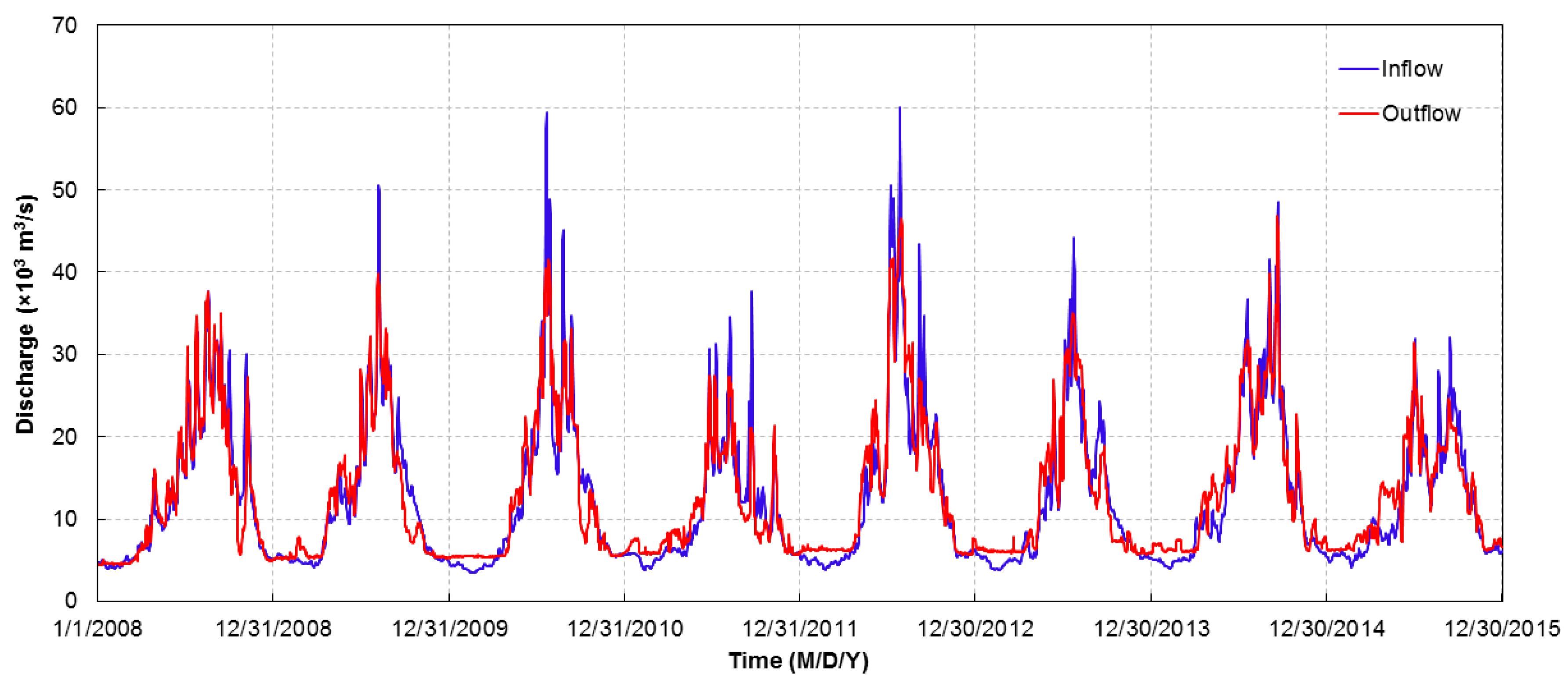
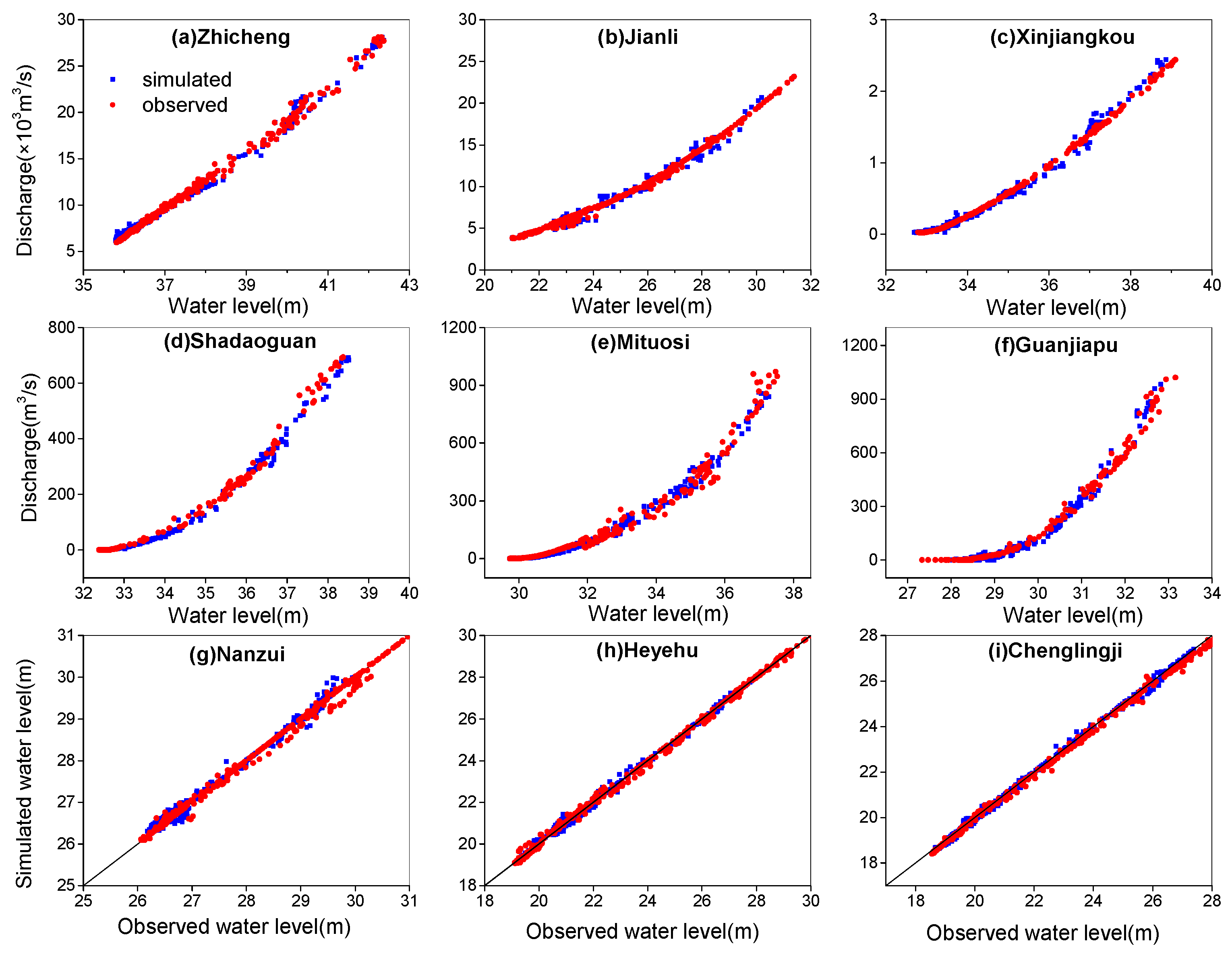
3.1. Model Calibration and Validation

The model was calibrated based on the hydrological process in 2008 and validated using the observed data in 2011. Flooding and drying events were both covered in the simulating periods. The channels in the river network were divided by 862 cross sections in the 1D model. The Dongting Lake area was divided into 23,436 grid cells and 12,923 nodes in the 2D hydrodynamic model. The grid layout was not equally spaced in this study. In particular, the grid of the deep channels in the lake area was greatly reduced the space, about 30~120 m, while the grid space of lake shoals was increased. It is well known that the Dongting Lake shape during the dry seasons is much more like a wide river due to the low stage. There is no water in the vast beach during the dry seasons. Therefore, the grid space was adjusted based on the topographical changes in the lake area, which was proven to be an effective mean to shorten the computing time on the premise of guaranteeing computation accuracy.
The initial value of the Manning roughness coefficient n was assigned according to the water depth in the river reaches and cell faces of the coupled model based on an empirical formula, n = n 0 h β [40], in which, n denotes the Manning roughness coefficient of the sections or cells; n 0 is the roughness coefficient when water depth is equal to 1 m; h is the total water depth; β is an empirical coefficient, generally set as 1 / 6 . In the calibration process, the value of the roughness coefficient was calibrated and adjusted based on the initial value and the observed water level at the different gauging stations of the river-lake system.
Table 2 and Figure 3 show the calibration and validation results of the coupled model. There was an obvious variation in the Manning roughness coefficient from one site to another due to the changes of surface friction characteristics. Crops, weeds, shrubs, and trees in the river point bars and lake shoals generally increase the bed roughness. As shown in the Figure 3, there is a good agreement between the simulated and observed data at the main gauging stations that are distributed in the lake and rivers. In addition, water volume difference between the accumulated inflow volume and the outflow volume should be equal to the difference between the initial and final water volume inside the lake area and river channels. The computing results of calibration in 2008 and validation in 2011 presented a good balance of water volume, the relative error were 2.8% and 3.2%, respectively, which indicated that the water conservation was satisfied in the coupled model.
The NSE and RMSE were computed and are shown in Table 3. The NSE at the most gauging stations was larger than 0.9 and RMSE was small enough, which indicated the coupled model could predict and evaluate the hydrological changes accurately after the TGR operation in the study area. The calibration and validation results of the coupled model based on the observed data in 2008 and 2011 show that there is a good agreement between the simulated and observed data at the Dongting river-lake system. The two important evaluation indicators, the NSE and RMSE, indicate that the coupled model can predict and evaluate the hydrological changes accurately after the operation of the TGR in the study area.

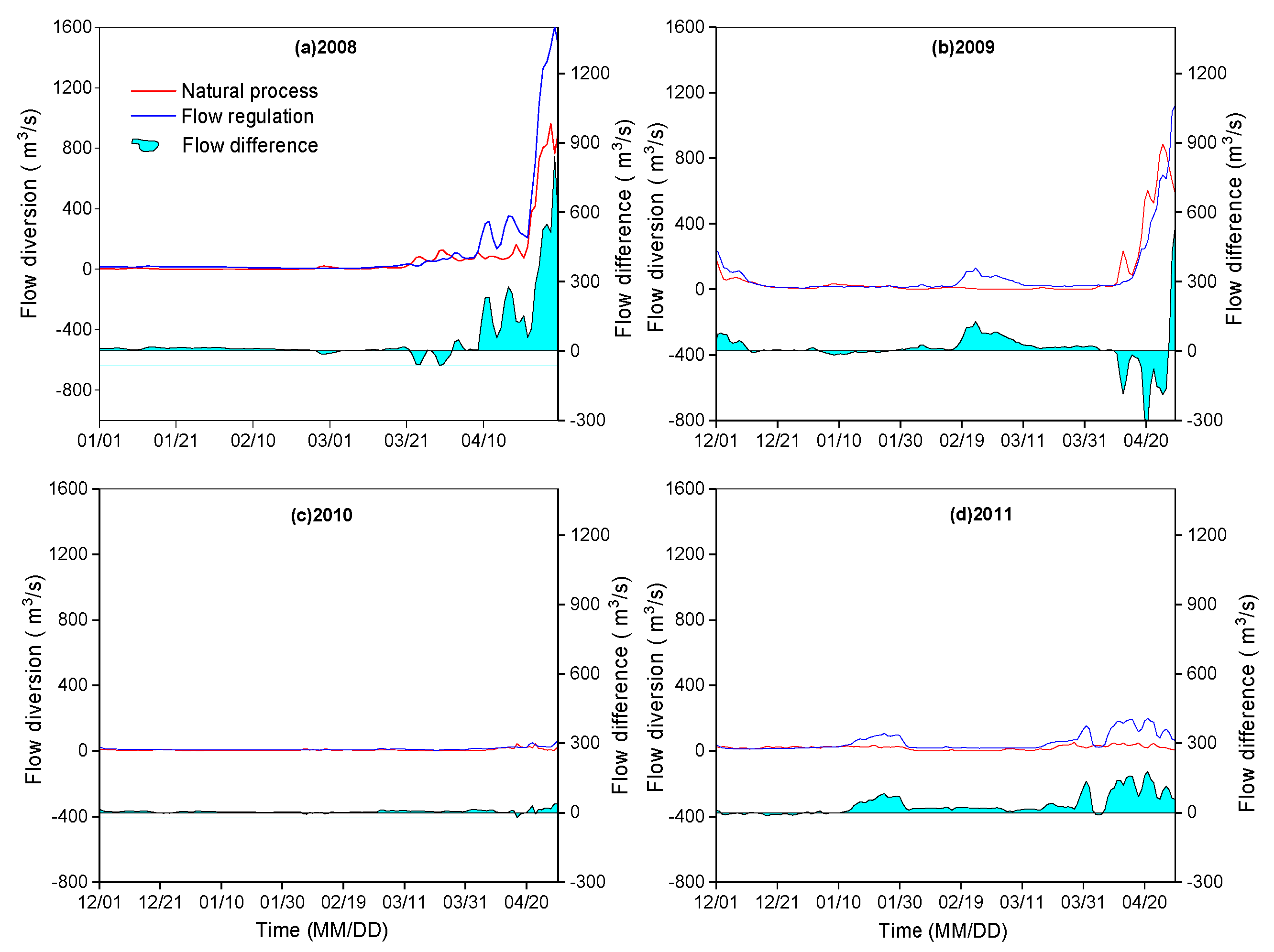
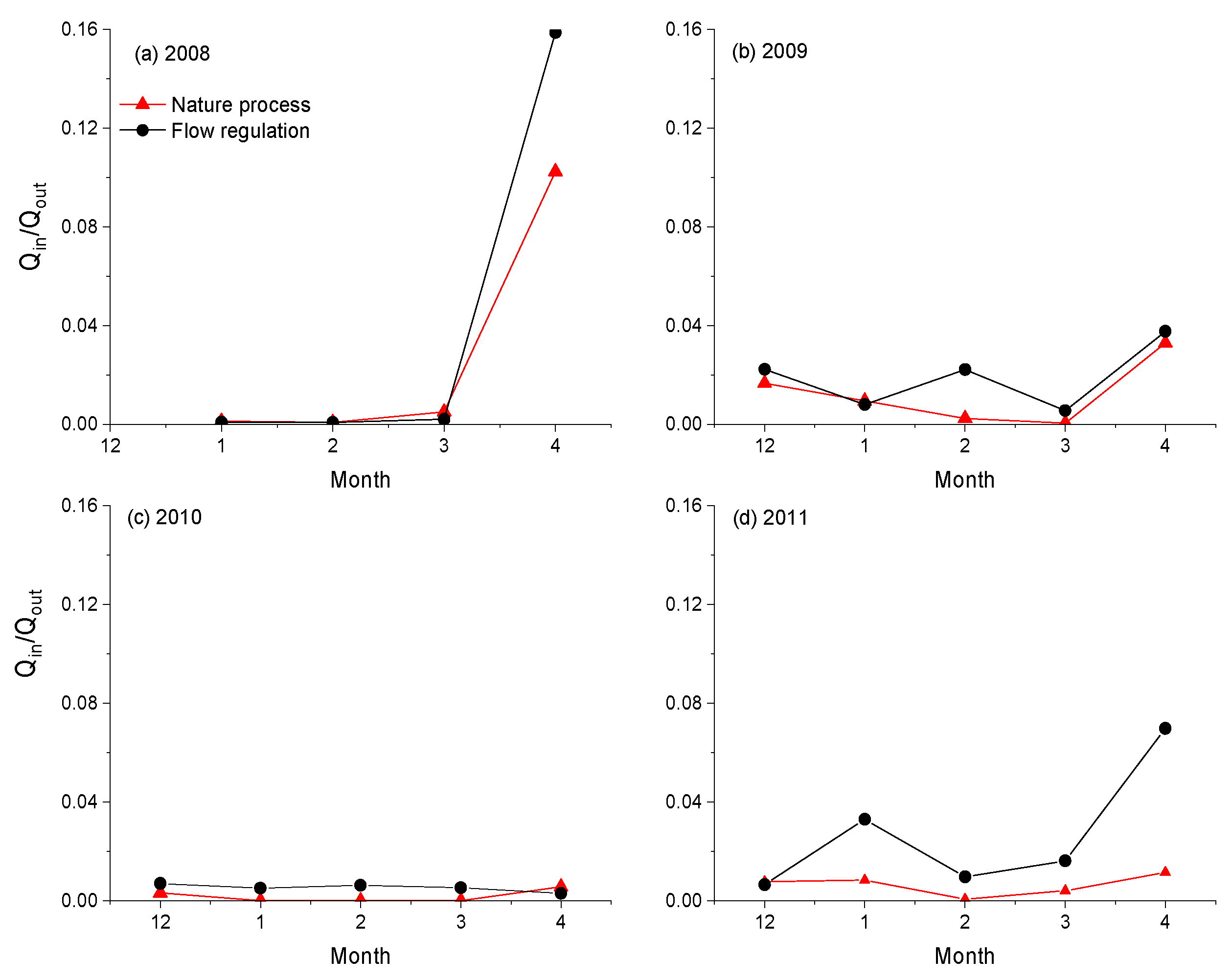
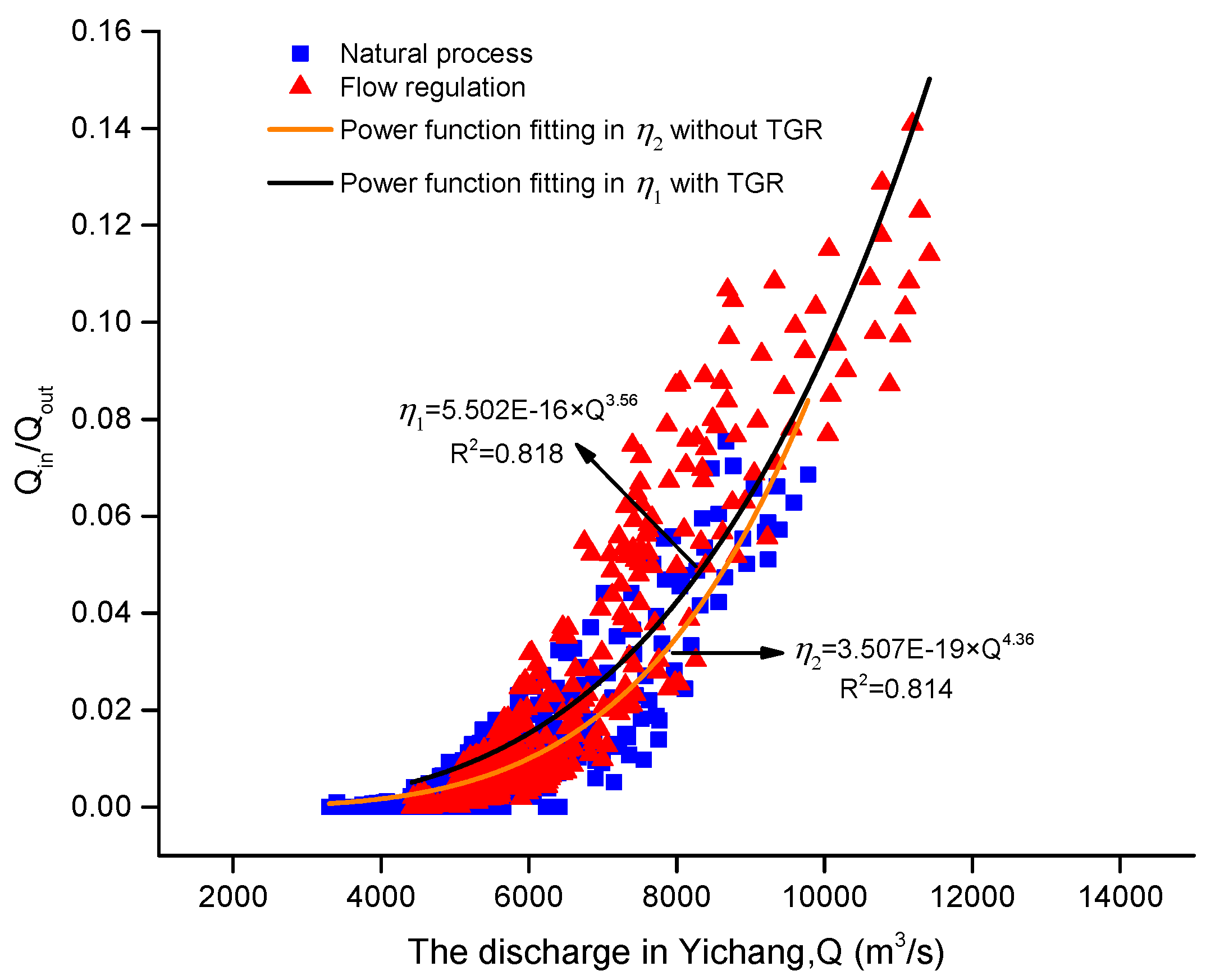
3.2. Water Exchanges between the Mainstream and the Dongting Lake

The flow regulation of the TGR greatly changed the downstream hydrological processes (Figure 2). The peak discharge was significantly reduced, while the low-flow discharge was compensated to some extent in the mainstream after the TGR operation. Therefore, there was an unavoidable impact on the water exchange in the river-lake system during the dry seasons (from the December to the following April). The processes of total flow diversion through the three inlets (Songzi, Taiping, and Ouchi) are shown in Figure 4 based on the computed results. However, there was no drastic flow increase at these inlets during the most time of water compensation. The largest flow increase generally occurred in April because of the beginning of flood pre-discharge control in the late April. The mean flow diversion during the four dry seasons from 2008 to 2011 was about 84.7 m3/s and 56.7 m3/s with and without the TGR, and the mean flow increase was approximately 28 m3/s after the TGR operation.
The water compensation from the TGR during the dry seasons increased the inflow to the river-lake system, which contributed to some extent to the changes of the diversion ratio. The diversion ratio referred to the value that the total discharge transferred from the mainstream to the tributaries and the Dongting Lake through the three inlets (Songzi, Taiping, and Ouchi) was normalized by the one at the Zhicheng station. The monthly mean diversion ratio with and without the TGR during the dry seasons is presented in Table 4. The diversion ratio under the TGR regulation was larger than the one without the TGR during the dry seasons. The maximum difference of diversion ratio occurred in April, about 0.56%. During the whole dry seasons from 2008 to 2011, the monthly mean regulated flow diversion ratio was about 0.894%, which was higher than the one without the TGR by 0.304%. The increased water diversion volume was about 4 × 10⁷ m3 during the dry seasons, which was about the 4.6% of the annually diverted volume without the TGR.
The coefficient of water exchange was introduced to show the variation in the water exchange between the rivers and the Dongting Lake during the dry seasons in Figure 5. The coefficient of water exchange was the ratio of total flow through the three inlets (Songzi, Taiping, Ouchi) to the flow discharge at the Chenglingji station. As shown in the Figure 5, the coefficient of water exchange with the TGR was generally larger than the one without the TGR. The increase in flow ratio implied that there was more water being stored up in the Dongting Lake. In particular, the increase in water volume of the Dongting Lake was about 0.38 × 10⁹ m3, 0.23 × 10⁹ m3, 0.39 × 10⁹ m3, and 0.47 × 10⁹ m3, respectively, during the dry seasons from 2008 to 2011, which avoided the extensive drying-up in the lake area from January to March. The increased flow and higher stage during the water compensation in the mainstream increased the flow diversion and restrained the outflow from the lake area. The water compensation to the downstream of the TGR improved the water exchange processes in the river-lake system.

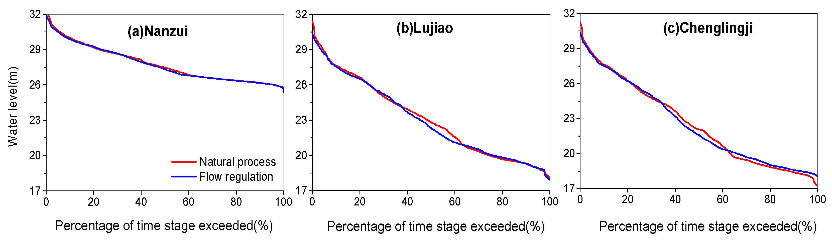
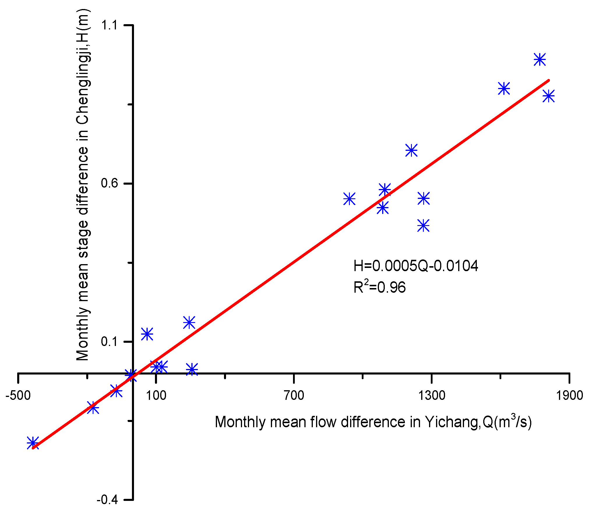
3.3. Changes of Water Level in the River-Lake System

The water compensation after the TGR operation not only increased the inflow of the mainstream and flow diversion, but it also changed the process of water level in the Dongting Lake area. The stage-duration curves with and without the TGR at the Nanzui, Lujiao, and Chenglingji stations are shown in Figure 6. There was no obvious difference in the extremely low water level at the Nanzui station with and without the TGR. However, it was slightly higher than the one without the TGR at the Lujiao and Chenglingji stations when the percentage of time stage exceeded 62%. The low water level generally occurred from December to the following early April, about 120 days, in the Yangtze River basin, which just was the period of water compensation. Therefore, the changes in the extremely low water level were the response to the water compensation. As shown in the Figure 6, the flow regulation impact on the Dongting Lake was not the same in the different subarea. The influence of water compensation on the eastern Dongting Lake was more obvious than the western parts of the lake area. The closer to the lake outlet, the greater stage influence of water compensation has.
The Chenglingji station was located in the lowest site of the Dongting Lake, which gauged the flow processes from the lake area to the mainstream. Therefore, the variation in the low water level at the Chenglingji station can reveal, to some extent, the discharging and impounding results of the Dongting Lake. In order to describe the changes in the low water level at the Chenglingji station, the water level L95, with the exceedance frequency of 95%, was selected as a characteristic parameter to show the stage changes during the dry seasons. The variation in the L95 at the Chenglingji with and without the TGR from 2008 to 2011 is shown in Figure 7. The annual characteristic parameter L95 under the operation of the TGR was obviously larger than the one without the TGR, except for 2008. The characteristic parameter L95 under the TGR regulation from 2008 to 2011 was 18.42 m, which was 0.26 m higher than the one without the TGR.

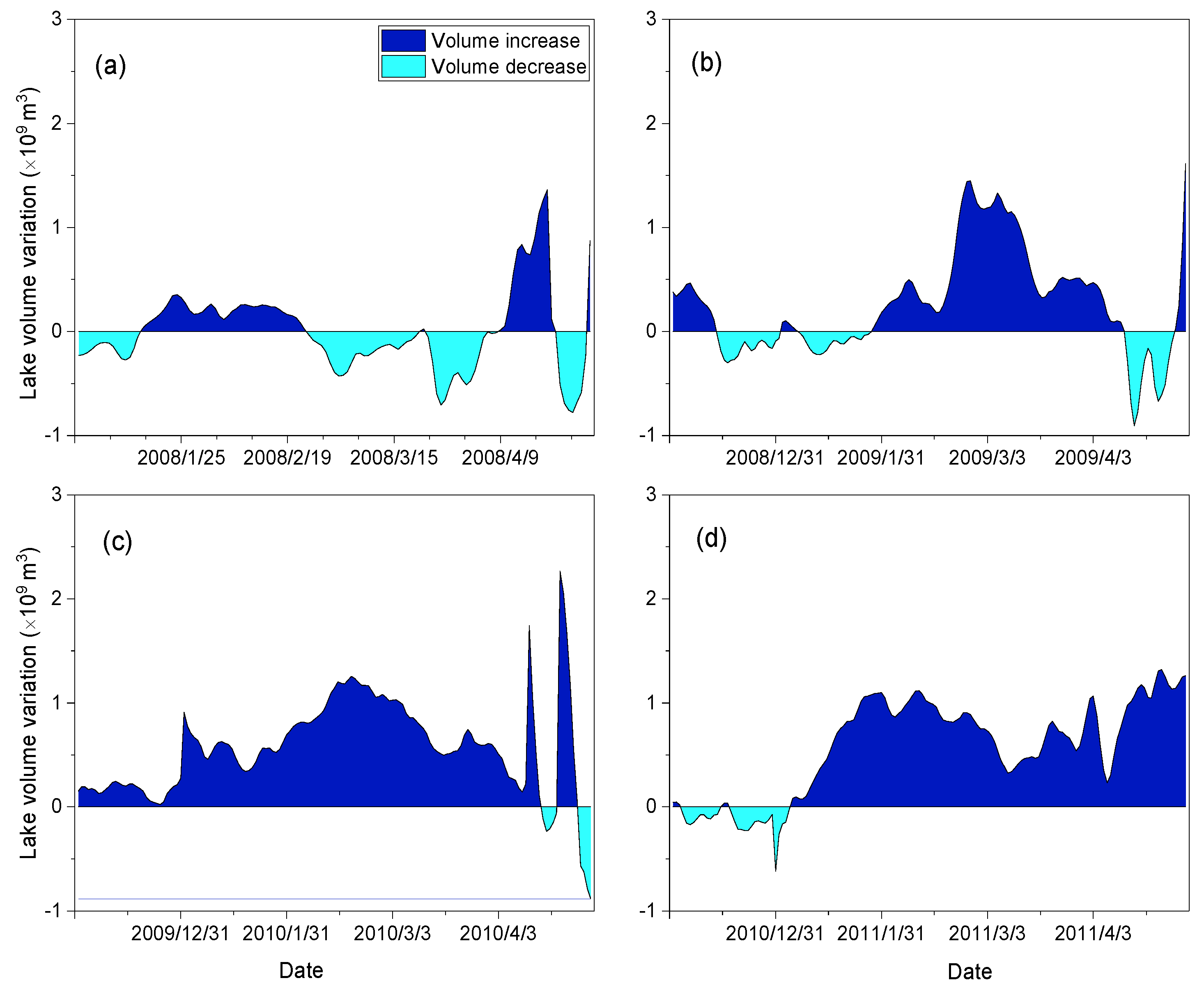
3.4. Variation in Lake Volume

The variation in the water exchange after the TGR operation was certain to lead to the lake volume change. Figure 8 shows the volume variation of the Dongting Lake during the dry seasons from 2008 to 2011. When compared with the natural processes, there was remarkable volume increase during the dry seasons due to the water compensation of the TGR. Because the normal flow regulation began from 2009, the impact of water compensation in 2008 on the lake volume was not as obvious as the ones at the other time. The volumetric differences during the four periods were obviously different with each other due to the variation in upstream inflow and water compensation. There was much more compensated water when a dry year occurred, such as 2011. The total compensated water was about 5.7 × 10⁸ m3 during the dry seasons in 2011, which lead to approximate 0.22 m water level increase.

4. Discussion

The water exchange between the mainstream and the Dongting Lake is an important hydrological process to keep the balance of the river-lake system. The flow increase in the mainstream during the period of water compensation from the TGR changed the hydraulic interaction, and finally reached a new balance in the system. Figure 9 presents the relationship between the coefficient of water exchange and the outflow from the TGR. As shown in the Figure 9, there is a good agreement between the coefficient of water exchange and outflow from the TGR, which indicates that the outflow from the TGR has a direct influence on the water exchange between the mainstream and the Dongting Lake. With the increase in the outflow from the TGR, the coefficient of water exchange increases in the form of a power function. Therefore, the outflow increase of the TGR resulted in the variation in the water exchange between the mainstream and the Dongting Lake, which contributed to relieving the extreme drought to some extent.
The outflow from the TGR increased during the water compensation from December to the following April, which changed the hydraulic interaction between the rivers and the lake area. Therefore, the changed hydraulic interaction may lead to some variations in the water level along the channels. The relationship between the flow difference at the Yichang station and the water level difference at the Chenglingji station with and without the TGR is shown in Figure 10. With the increase of flow difference, there is an obvious linear increase in the water level difference. When compared with the unregulated flow, there will be an increase about 0.49 m in the water level at the Chenglingji station when the flow increase is up to 1000 m3/s during the dry seasons. The water level at the lowest outlet of the Dongting Lake reflects the magnitude of lake volume. Therefore, the volume change in the lake area was the response to the variation in the hydraulic interaction of the river-lake system.
In fact, the stage changes in the lake area were closely related to the inflow and outflow of the Dongting Lake [41]. Figure 11 presents the relationship between the outflow at the Chenglingji station and the hydraulic gradient and discharge at the Yichang station. The increase in flow discharge at the Yichang station made nearly no difference to the outflow of the Dongting Lake when the hydraulic gradient was between 0.000043~0.000048. While the hydraulic gradient was smaller than 0.000043 or larger than 0.000048, the outflow increased greatly with the flow increase at the Yichang station. However, the hydraulic gradient played an important role in the whole changing processes of outflow. The outflow variation directly resulted in the changes of water level and water volume in the Dongting Lake. Therefore, in order to contribute to the ecological restoration and environmental improvement in the river-lake system, much more attention should be paid to the hydraulic gradient variation, which greatly affects the hydraulic interaction between the rivers and the Dongting Lake. When there is a constant outflow from the TGR, i.e., the discharge at the Yichang station is kept the same, the outflow from the Dongting Lake to the Yangtze River can be adjusted by the hydraulic gradient to some extent. Consequently, a reasonable hydraulic gradient definitely contributes to the improvement of water volume of the Dongting Lake during the extremely dry seasons.

5. Conclusions

Hydrological changes occurred increasingly frequently around the world due to the widespread influences of anthropogenic activities. Water compensation of the TGR, as one of the important flow regulation measures, greatly contributed to the changes of hydrological regime in the downstream river-lake system. Based on the hydrodynamic model simulation and data analysis, the interesting and important conclusions have been drawn, as follows:
(1) Water exchange between the Yangtze River and the Dongting Lake was further strengthened after the TGR operation. Flow diversion from the Yangtze River to the Dongting Lake increased to different degrees during the dry seasons from 2008 to 2011. Furthermore, the coefficient of water exchange also increased during the water compensation periods of the TGR, which implied that there was a less increase in the outflow from the Dongting Lake.
(2) There was no good agreement in lake level changes at the lake gauging stations. When the time stage percentage was larger than 62%, the lake level at the Chenglingji outlet markedly increased due to the level increase in the mainstream. The lake level, with a possibility of 95% at the Chenglingji outlet, increased by 0.26 m under the water compensation from the TGR than the one without the TGR. Consequently, the lake volume also increased to different degrees during the dry seasons from 2008 to 2011.
(3) The changes in inflow and outflow of the Dongting Lake were the determining factors of the hydrological regime of lake area. The water exchange between the Yangtze River and the Dongting Lake principally resulted from the outflow from the TGR and the hydraulic gradient between the inlets and the outlet of the Dongting Lake. When the water compensation is conducted at the proper hydraulic gradient range, the lake level and water volume will be effectively improved in the Dongting Lake, consequently, the ecological environment will also be recovered to some extent during the dry seasons.

Author Contributions

J.Z. and M.D. conceived the article structure and collected the data; D.W. and W.X. analyzed the data; T.Y. edited the manuscript. L.F. contributed materials/analysis tools; L.C. wrote the paper.

Funding

This research was funded by National Key R&D Program of China (2017YFC0405900); the National Natural Science Foundation of China (51509273, 51679094, 51409085); the National Key Research and Development Plan (2016YFC0400901); Open Foundation of State Key Laboratory of Hydrology-Water Resources and Hydraulic Engineering (2015491111); the Open Research Fund of State Key Laboratory of Simulation and Regulation of Water Cycle in River Basin (China Institute of Water Resources and Hydropower Research), Grant NO: IWHR-SKL-201607, 2016TS07; the Technology Demonstration Projects of Ministry of Water Resources (SF2016-10); the Research and Development Projects on Application Technology of Heilongjiang Province (GZ16B011) and Fundamental Research Funds for the Central Universities (2017KFYXJJ194, 2016YXZD048).

Acknowledgments

The authors gratefully acknowledge the anonymous reviewers and editors for their careful reviews and suggestions, which significantly contributed to the manuscript improvement.

Conflicts of Interest

The authors declare no conflicts of interest. The founding sponsors had no role in the design of the study; in the collection, analyses, or interpretation of data; in the writing of the manuscript; nor in the decision to publish the results.

References

  1. Omer, A.M. Energy, environment and sustainable development. Renew. Sust. Energy Rev. 2008, 12, 2265–2300. [Google Scholar] [CrossRef]
  2. Fang, C.; Bao, C.; Huang, J. Management implications to water resources constraint force on socio-economic system in rapid urbanization: A case study of the Hexi Corridor, NW China. Water Resour. Manag. 2007, 21, 1613–1633. [Google Scholar] [CrossRef]
  3. Chen, L.; Singh, V.P.; Huang, K.D. Bayesian Technique for the Selection of Probability Distributions for Frequency Analyses of Hydrometeorological Extremes. Entropy 2018, 20, 117. [Google Scholar] [CrossRef]
  4. González-Fernández, R.A.; Oviedo-Sanabria, R.E.; Leite da Silva, A.M. Generating capacity reliability assessment of the Itaipu hydroelectric plant via sequential Monte Carlo simulation. In Proceedings of the Power Systems Computation Conference (PSCC), Wroclaw, Poland, 18–22 August 2014; pp. 1–7. [Google Scholar]
  5. Postel, S.; Richter, B. Rivers for Life: Managing Water for People and Nature; Island Press: Washington, DC, USA, 2012. [Google Scholar]
  6. Tecle, A. Downstream Effects of Damming the Colorado River. Int. J. Lakes Rivers 2017, 10, 7–33. [Google Scholar]
  7. Mendelssohn, I.A.; Andersen, G.L.; Baltz, D.M.; Caffey, R.H. Oil impacts on coastal wetlands: Implications for the Mississippi River Delta ecosystem after the Deepwater Horizon oil spill. Bioscience 2012, 62, 562–574. [Google Scholar] [CrossRef]
  8. Chen, L.; Singh, V.P.; Guo, S.; Hao, Z.; Li, T. Flood coincidence risk analysis using multivariate copula functions. J. Hydrol. Eng. 2011, 17, 742–755. [Google Scholar] [CrossRef]
  9. Chen, L.; Singh, V.P.; Guo, S.; Zhou, J.; Zhang, J. Copula-based method for multisite monthly and daily streamflow simulation. J. Hydrol. 2015, 528, 369–384. [Google Scholar] [CrossRef]
  10. Grizzetti, B.; Pistocchi, A.; Liquete, C.; Udias, A.; Bouraoui, F.; van de Bund, W. Human pressures and ecological status of European rivers. Sci. Rep. 2017, 7, 205. [Google Scholar] [CrossRef] [PubMed]
  11. Duc, N.A.; Nguyen, L.T.; Thai, T.H.; Khan, A.; Rautenstrauch, K.; Schmidt, C. Assessing Cumulative Impacts of the Proposed Lower Mekong Basin Hydropower Cascade on the Mekong River Floodplains and Delta–Overview of Integrated Modeling Methods and Results. J. Hydrol. 2018, in press. [Google Scholar]
  12. Wisser, D.; Frolking, S.; Douglas, E.M.; Fekete, B.M. The significance of local water resources captured in small reservoirs for crop production—A global-scale analysis. J. Hydrol. 2010, 384, 264–275. [Google Scholar] [CrossRef]
  13. Rahel, F.J.; Olden, J.D. Assessing the effects of climate change on aquatic invasive species. Conserv. Biol. 2008, 22, 521–533. [Google Scholar] [CrossRef] [PubMed]
  14. Liu, Z.; Guo, S.; Guo, J.; Liu, P. The impact of Three Gorges Reservoir refill operation on water levels in Poyang Lake, China. Stoch. Environ. Res. Risk Assess. 2017, 31, 879–891. [Google Scholar] [CrossRef]
  15. Huang, Z.; Wu, B. Ecological and Environmental Monitoring After Reservoir Impoundment. In Three Gorges Dam; Springer: Myrtle Beach, SC, USA, 2018; pp. 279–306. [Google Scholar]
  16. Chen, L.; Singh, V.P. Entropy-based derivation of generalized distributions for hydrometeorological frequency analysis. J. Hydrol. 2018, 557, 699–712. [Google Scholar] [CrossRef]
  17. Mao, J.; Zhang, P.; Dai, L.; Dai, H.; Hu, T. Optimal operation of a multi-reservoir system for environmental water demand of a river-connected lake. Hydrol. Res. 2016, 47, 206–224. [Google Scholar] [CrossRef] [Green Version]
  18. Yang, S.; Milliman, J.D.; Xu, K.; Deng, B.; Zhang, X.; Luo, X. Downstream sedimentary and geomorphic impacts of the Three Gorges Dam on the Yangtze River. Earth-Sci. Rev. 2014, 138, 469–486. [Google Scholar] [CrossRef]
  19. Song, Y.; Cheng, F.; Murphy, B.R.; Xie, S. Downstream effects of the Three Gorges Dam on larval dispersal, spatial distribution, and growth of the four major Chinese carps call for reprioritizing conservation measures. Can. J. Fish. Aquat. Sci. 2017, 75, 141–151. [Google Scholar] [CrossRef]
  20. Gao, X.; Lin, P.; Li, M.; Duan, Z.; Liu, H. Impact of the Three Gorges Dam on the spawning stock and natural reproduction of Chinese sturgeon in Changjiang River, China. Chin. J. Oceanol. Limnol. 2016, 34, 894–901. [Google Scholar] [CrossRef] [Green Version]
  21. Feng, L.; Hu, C.; Chen, X.; Zhao, X. Dramatic inundation changes of China’s two largest freshwater lakes linked to the Three Gorges Dam. Environ. Sci. Technol. 2013, 47, 9628–9634. [Google Scholar] [CrossRef] [PubMed]
  22. Huang, Q.; Sun, Z.D.; Opp, C.; Lotz, T.; Jiang, J.H.; Lai, X.J. Hydrological Drought at Dongting Lake: Its Detection, Characterization, and Challenges Associated with Three Gorges Dam in Central Yangtze, China. Water Resour. Manag. 2014, 28, 5377–5388. [Google Scholar] [CrossRef]
  23. Li, S.; Xiong, L.; Dong, L.; Zhang, J. Effects of the Three Gorges Reservoir on the hydrological droughts at the downstream Yichang station during 2003–2011. Hydrol. Process. 2013, 27, 3981–3993. [Google Scholar] [CrossRef]
  24. Lai, X.; Jiang, J.; Yang, G.; Lu, X.X. Should the Three Gorges Dam be blamed for the extremely low water levels in the middle-lower Yangtze River? Hydrol. Process. 2014, 28, 150–160. [Google Scholar] [CrossRef]
  25. Wang, J.; Sheng, Y.; Wada, Y. Little impact of the Three Gorges Dam on recent decadal lake decline across China’s Yangtze Plain. Water Resour. Res. 2017, 53, 3854–3877. [Google Scholar] [CrossRef]
  26. Zhang, W.; Yang, Y.; Zhang, M.; Li, Y.; Zhu, L.; You, X.; Wang, D.; Xu, J. Mechanisms of suspended sediment restoration and bed level compensation in downstream reaches of the Three Gorges Projects (TGP). J. Geogr. Sci. 2017, 27, 463–480. [Google Scholar] [CrossRef]
  27. Chen, X.; Yan, Y.; Fu, R.; Dou, X.; Zhang, E. Sediment transport from the Yangtze River, China, into the sea over the Post-Three Gorge Dam Period: A discussion. Quat. Int. 2008, 186, 55–64. [Google Scholar] [CrossRef]
  28. Chen, L.; Singh, V.P.; Guo, S.; Zhou, J.; Zhang, J.; Liu, P. An objective method for partitioning the entire flood season into multiple sub-seasons. J. Hydrol. 2015, 528, 621–630. [Google Scholar] [CrossRef]
  29. Chen, L.; Guo, S.; Yan, B.; Liu, P.; Fang, B. A new seasonal design flood method based on bivariate joint distribution of flood magnitude and date of occurrence. Hydrol. Sci. J. 2010, 55, 1264–1280. [Google Scholar] [CrossRef] [Green Version]
  30. Liu, X.; Chen, L.; Zhu, Y.; Singh, V.P.; Qu, G.; Guo, X. Multi-objective reservoir operation during flood season considering spillway optimization. J. Hydrol. 2017, 552, 554–563. [Google Scholar] [CrossRef]
  31. Three Gorges Corporation. Available online: http://www.ctg.com.cn/ (accessed on 15 May 2018).
  32. Danish Hydraulic Institute (DHI). A Modelling System for Rivers and Channels. In Reference Manual; DHI Water & Environment: Aarhus N, Denmark, 2011. [Google Scholar]
  33. Danish Hydraulic Institute (DHI). MIKE 21 Flow Model: Hydrodynamic Module Scientific Documentation. In User Mannual; DHI: Horsholm, Denmark, 2009. [Google Scholar]
  34. DHI. MIKE FLOOD 1D-2D Modelling. In User Manual; DHI: Horsholm, Denmark, 2007; pp. 5–20. [Google Scholar]
  35. Zhao, D.; Shen, H.; Tabios, G., III; Lai, J.; Tan, W. Finite-volume two-dimensional unsteady-flow model for river basins. J. Hydraul. Eng. 1994, 120, 863–883. [Google Scholar] [CrossRef]
  36. Sleigh, P.; Gaskell, P.; Berzins, M.; Wright, N. An unstructured finite-volume algorithm for predicting flow in rivers and estuaries. Comput. Fludids 1998, 27, 479–508. [Google Scholar] [CrossRef]
  37. Cunge, J.A. On the subject of a flood propagation computation method (Musklngum method). J. Hydraul. Res. 1969, 7, 205–230. [Google Scholar] [CrossRef]
  38. Zhang, J.; Chen, L.; Singh, V.P.; Cao, H.; Wang, D. Determination of the distribution of flood forecasting error. Nat. Hazards 2015, 75, 1389–1402. [Google Scholar] [CrossRef]
  39. Chen, L.; Singh, V.P.; Lu, W.; Zhang, J.; Zhou, J.; Guo, S. Streamflow forecast uncertainty evolution and its effect on real-time reservoir operation. J. Hydrol. 2016, 540, 712–726. [Google Scholar] [CrossRef]
  40. Jiang, J.H.; Lai, X.J.; Huang, Q. The characteristics of flood responses to the restoration of polders on Dongting Lake, China. Hydrol. Sci. J. 2007, 52, 671–685. [Google Scholar]
  41. Dai, M.L.; Wang, J.; Zhang, M.B.; Chen, X. Impact of the Three Gorges Project operation on the water exchange between Dongting Lake and the Yangtze River. Int. J. Sediment. Res. 2017, 32, 506–514. [Google Scholar] [CrossRef]
Figure 1. Location of the river-lake system in the middle Yangtze River.
Water 10 01011 g001
Figure 2. Inflow and outflow process of the Three Gorges Reservoir (TGR) from 2008 to 2015.
Water 10 01011 g002
Figure 3. Model calibration results at the gauging stations in the river-lake system.
Water 10 01011 g003
Figure 4. Flow diversions during the dry seasons with and without the TGR.
Water 10 01011 g004
Figure 5. Variation in coefficient of water exchange in the river-lake system with and without the TGR. Qin is the total flow through the three inlets (Songzi, Taiping, Ouchi); Qout is the outflow through the Chenglingji outlet; The natural processes are the results without the TGR, while the flow regulation is the results under the operation of the TGR.
Water 10 01011 g005
Figure 6. Stage-duration curves with and without the TGR at the main lake stations.
Water 10 01011 g006
Figure 7. Changes in the water level with a possibility of 95% at the Chenglingji station.
Water 10 01011 g007
Figure 8. Volumetric differences during dry seasons with and without the TGR (2008–2011). (ad) denote the water compensation periods of each year from 2008 to 2011.
Water 10 01011 g008
Figure 9. Relationship between the coefficient of water exchange and the outflow discharge of the TGR during the dry seasons (December to the following April) from 2008 to 2011. η 1 and η 2 denote the coefficients of water exchange with and without the TGR.
Water 10 01011 g009
Figure 10. Relationship between the water level difference at the Chenglingji station and the outflow difference at the Yichang station with and without the TGR.
Water 10 01011 g010
Figure 11. Outflow processes with the discharge and hydraulic gradient during the dry seasons (December to the following April) from 2008 to 2011. The outflow of the Dongting Lake was observed at the Chenglingji station; the hydraulic gradient was between the Zhicheng and Chenglingji stations.
Water 10 01011 g011
Table 1. The detailed information of gauging stations in the river-lake system.
Series No.Station NameLocationCatchment Area (km2)Parameters Gauged
LongitudeLatitude
1Yichang111°17′ E30°42′ N1,005,501.00water level, discharge
2Zhicheng111°30′ E30°30′ N1,024,131.00
3Shashi112°13′ E30°18′ N1,028,415.00
4Jianli112°53′ E29°49′ N1,033,274.00
5Chenglingji113°08′ E29°25′ N262,344.00
6Luoshan113°22′ E29°40′ N1,294,911.00
7Taojiang112°06′ E28°55′ N25,788.00
8Taoyuan111°29′ E28°54′ N90,530.00
9Shimen111°23′ E29°37′ N17,942.00
10Nanzui112°18′ E29°03′ N-water level
11Heyehu112°54′ E28°52′N-
12Shawan112°18′ E28°55′ N-
13Lujiao113°07′ E29°08′ N-
14Yingtian112°55′ E28°51′ N-
15Xinjiangkou111°47′ E30°18′ N-water level, discharge
16Shadaoguan111°55′ E30°18′ N-
17Mituosi112°07′ E30°22′ N-
18Kangjiagang112°18′ E29°73′ N-
19Guanjiapu112°19′ E29°73′ N-
Table 2. Manning roughness coefficients in the coupled model.
SubareaDeep ChannelsShoals in the LakePoint Bars in Rivers
Lake area0.021~0.0340.032~0.059-
Mainstream0.018~0.035-0.025~0.046
Tributaries0.019~0.033-0.023~0.042
Table 3. Computed results of Nash-Sutcliffe efficiency coefficients (NSE) and the normalized root mean squared error (RMSE) at the main gauging stations.
No.Stations20082011
Discharge (m3/s)Elevation (m)Discharge (m3/s)Elevation (m)
NSERMSENSERMSENSERMSENSERMSE
1Zhicheng0.9920.1320.9930.0040.9910.1340.9880.004
2Shashi0.9860.1210.9880.0110.9840.1240.9790.007
3Jianli0.9890.1360.9690.0160.990.1290.9840.012
4Nanzui--0.9750.005--0.9720.01
5Heyehu--0.9840.014--0.9820.013
6Chenglingji0.8960.1520.9910.0140.8910.1610.990.011
7Shadaoguan0.9310.1560.9610.0180.9320.0710.9840.019
8Xinjiangkou0.9470.1420.9870.0210.9390.0690.9910.023
9Mituosi0.9680.2330.9820.0160.9720.1050.9760.014
10Kangjiagang0.9270.1520.9140.0230.9350.1380.9130.025
11Guanjiapu0.9350.1310.9050.0170.9290.1240.9010.019
Table 4. Monthly mean discharge and flow diversion ratio with and without the TGR during the dry seasons from 2008 to 2011, %.
Runoff ProcessesDiversion RatioMonthly Mean Discharge (m3/s)
Dec.Jan.Feb.Mar.Apr.Three OutletsZhicheng
TGR, R10.440.480.380.452.7284.76210
No TGR, R20.360.20.040.192.1656.75590
R1R20.080.280.340.260.5628620
Note: the R1 and R2 denote the flow diversion ratio with and without the TGR during the dry seasons.

