Intelligent Evaluation System of Water Inrush in Roadway (Tunnel) and Its Application
by
Shaoshuai Shi
1,2,3, 
Xiaokun Xie
1,2,
Zhijie Wen
3,*,
Zongqing Zhou
1,2,3,*,
Liping Li
1,2,
Shuguang Song
4 and
Zhonghu Wu
5 1
School of Qilu Transportation, Shandong University, Jinan 250061, China
2
Geotechnical and Structural Engineering Research Center, Shandong University, Jinan 250061, China
3
State Key Laboratory of Mining Disaster Prevention and Control, Shandong University of Science and Technology, Qingdao 266590, China
4
School of Transportation Engineering, Shandong Jianzhu University, Jinan 250061, China
5
School of Civil Engineering, Guizhou University, Guiyang 550025, China
*
Authors to whom correspondence should be addressed.
Water 2018, 10(8), 997; https://doi.org/10.3390/w10080997
Submission received: 4 July 2018
/
Revised: 24 July 2018
/
Accepted: 25 July 2018
/
Published: 27 July 2018
(This article belongs to the Special Issue Thermo-Hydro-Mechanical-Chemical Processes of Deep Underground Reservoirs)
Abstract
:The risk assessment of mine water inrush is a complicated theoretical and technical problem that concerns hydrogeology conditions, engineering geology, mining conditions, rock mechanics, etc. To address this problem, a software system for the risk assessment of mine water inrush was established. From the matter-element extension theory, combined with the entropy-weight method, a matter-element extension entropy-weight model was constructed to evaluate mine safety. Eleven indices were determined based on the principles of science, rationality, operability, and representation, and each index was quantitatively graded. This system had built-in abundant cases of typical mine water inrush so users could determine the value of the parameter according to the analogy of water inrush cases with similar conditions. Combined with the analysis of typical water inrush cases, a database of water control measures with a strong advisory function was established. Finally, through the case study of a typical mine, it was found that the results of this study agreed with the practical ones, indicating that this system could improve the accuracy and availability of the risk assessment of mine water inrush.
1. Introduction
With the frequent occurrence of mine water inrush in recent years, increasing attention is being paid to the risk assessment of mine water inrush. Water inrushes have caused many casualties and tremendous economic loss. Consequently, the effective risk assessment of mine water inrush is extremely important for successful coal mining.
Currently, scholars have conducted considerable research on risk assessment methods for mine water inrush. Jafar et al. illustrated the application of fuzzy set theory in water inrush grade assessment processes and applied it to an engineering case [1]. Hua et al. put forward the notion of mine water inrush phenomena caused by fault activation and set up a mathematical model of the non-linear dynamic phenomenon based on catastrophe theory [2]. According to the lithology and structural features of coal seams, Meng et al. proposed a mine water inrush risk assessment method based on a conventional water inrush coefficient [3]. Lin et al. constructed the matter–element model for the assessment analysis of coal mine water hazard safety with a combination of interval empowerment and extension theory [4]. Li and Chen set up an evaluation model by using a grey relational analysis and analytic hierarchy process (AHP), whose availability improved the uncertainty between indexes of mine water inrush effects and reflected the degree of importance for each index of mine water inrush effects [5]. Ruan et al. improved the AHP and used it to determine the weight of each factor and then set up a reasonable mine water inrush risk evaluation system [6]. Krzysztof et al. described the quantity of water that entered the mine dewatering systems, the weather conditions for the period preceding the inrush, the hydrogeological conditions, and the underground hydraulic connections and identified a need to rebuild damaged mines [7]. Yang et al. established a systematic method that was used to evaluate the risk of mine water inrush using a geographic information system (GIS) and fuzzy set theory. The main hydrogeological indicators that control mine water inrush were considered using a fuzzy mathematics approach where fractal analysis was used to quantify the fault’s characteristics [8]. Xu and Sun established a coal mine water inrush risk evaluation system by using an analytic hierarchy process structure to analyze coal mine water-related factors [9]. Qiu et al. used an innovative combination of methods to assess the risk of water inrush based on the fuzzy Delphi analytic hierarchy process (FDAHP) and grey relational analysis (GRA) [10]. Neural networks are also used to evaluate the risk of water inrush [11].
Although the above theories and methods have been used to analyze the risk of mine water inrush, each aforementioned method has disadvantages. For example, the precision of AHP primarily depends on the reliability of the risk recursive model. As the determination of the membership function includes certain subjectivity and arbitrariness, grey relational analysis and AHP may lead to unreasonable results. Additionally, when evaluating the risk of mine water inrush, the value of the index is often an exact value, which neglects the complexity of the hydrogeologic conditions for underground engineering and the uncertainty of the risk. Most evaluation models can only qualitatively or semi-quantitatively evaluate the risk of mine water inrush.
Considering the diversity of influencing factors of mine water inrush accidents, we sought to establish a human–computer interactive system used to assess the water inrush risk level of mines based on a matter–element extension entropy-weight model. The system can expand the range of values of the correlation function, transform a definite single value to an interval value of the evaluation index, and use the entropy method to calculate the weight coefficient of the evaluation index, which can overcome the subjectivity of the weight coefficient and avoid human interference [12,13].
2. Overview of Mine Water Inrush Risk Assessment System
The system determines the parameters of each evaluation index through a comprehensive analysis of geological conditions, mining methods, and risk management. The correlation degree of each index is calculated by a simple correlation function, the weight of each index is calculated by the entropy weight method, and a certain calculation process is introduced into the analysis program to calculate the mine water inrush risk level. As a forecasting and consulting system, the system can make a scientific assessment for the danger of mine water inrush and provide the basis for prevention and control of mine water inrush. Several characteristics of the system are as follows.
2.1. Quantization and Selection of Evaluation Indices
The influence factors of mine water inrush are complicated and it is difficult to analyze each factor when evaluating, so the most important and influential factors should be selected [14,15,16]. According to hundreds of mine water inrush cases in the past 50 years, the mine water inrush environment and factors have been analyzed [17,18,19]. Fault density, fault–water transmitting ability, fracture development degree, artesian water pressure, watery property of the aquifer, karst development degree, water recharging, thickness of aquifuge, strength of aquifuge, mining thickness, and mining depth were selected as the evaluation indices of mine water inrush and expressed by c1, c2, c3, …, c11, respectively. Quantifying the value of each index and combining the matter-element extension entropy-weight model, the risk grade of mine water inrush was calculated based on the boundaries proposed by Wang et al. [20]. The entire evaluation process included data preparation, risk-level evaluation, result statistics, and data storage.
2.2. Reliability of the Assessment System
To ensure acceptability and reliability, the system calculates the index weight of factors by means of entropy theory, then analyzes and evaluates the danger of mine water inrush according to a certain logical relationship, and gives full play to the advantages of software systems such as rich information, powerful computing function, and a rigorous reasoning and analysis process, resulting in a more objective and accurate evaluation of mine water inrush danger.
2.3. Extendibility of the Assessment System
The system is an open system and can be continuously expanded in its practical application; new cases can be added to the database, and the instance information can be modified manually. With the continuous improvement of the prediction and forecast method for mine water inrush, the database of the system can be inherited and accumulated, the reasoning process can be increasingly complete, and the function can be continuously strengthened.
3. Structure of the System
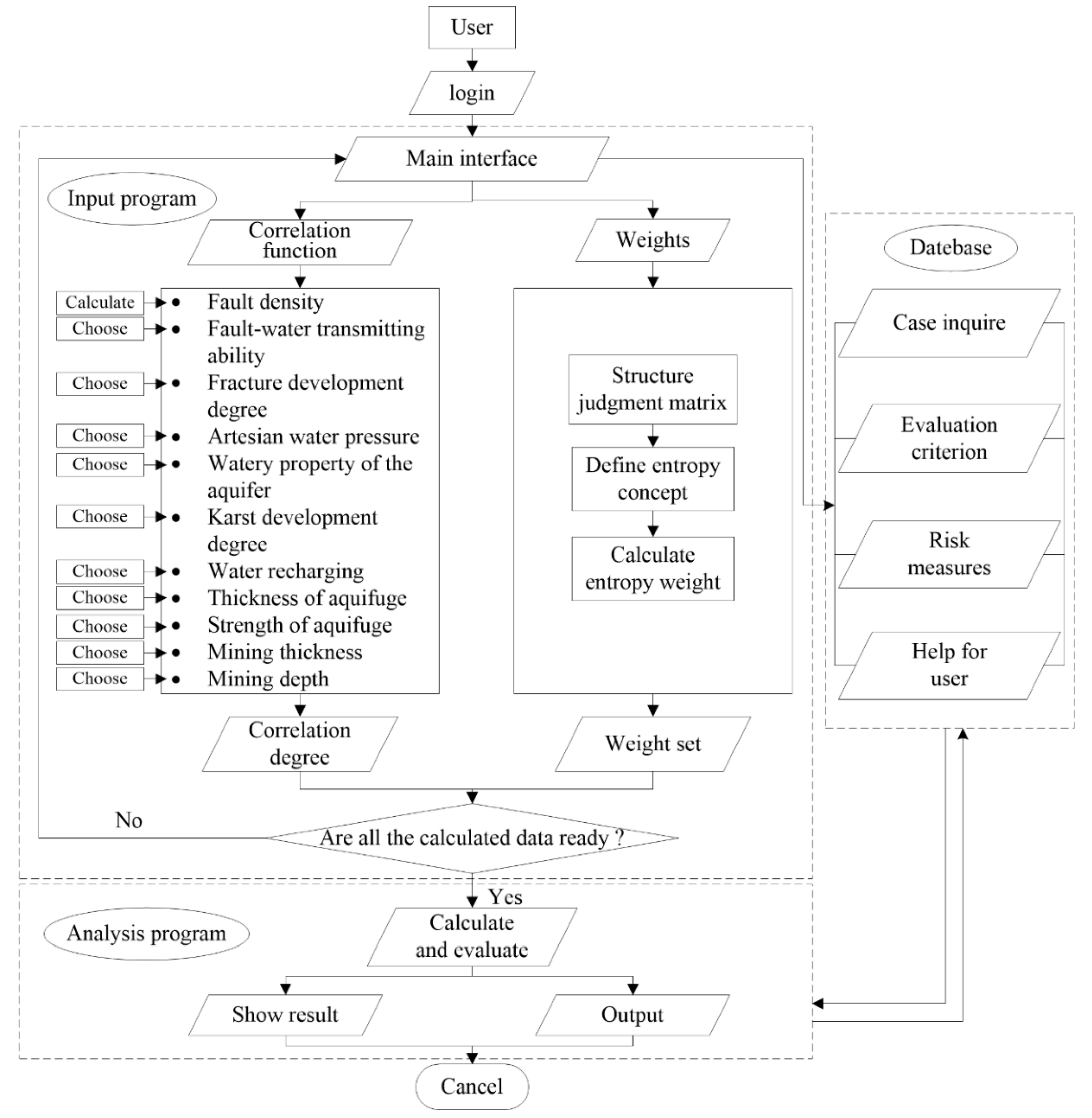
The evaluation system mainly consists of an input program, analysis program, and database. The basic framework of the software function is shown in Figure 1.
3.1. Input Program
3.1.1. Analysis of Risk Factors
Fault Density (c1)
The density of fault is usually expressed by the number of faults per unit area or the length of fault traces per unit area. The fault reduces the stability of a coal mine aquifuge; the larger the number of faults, the greater the damage area of the mine. The expansion of the damage area will be accelerated under the coupling action of mining-induced stress and artesian pressure. The speed of the expansion of the fracture has a great influence on water bursting in the mine [21,22].
Fault-Water Transmission Ability (c2)
Faults and fracture zones are the main channels between surface water and the coal mine. Fault water transmissivity mainly lies on the fault’s degree of crushing and the fault’s both-side aquifers’ contact relation. The fault fracture zone usually has good water conductivity and the water pressure in the broken fault zone is easily released, which can lead to the occurrence of water inrush in the working face or coal mine roadway [23].
Fracture Development Degree (c3)
Cracks in the coal seam floor can destroy the integrity of the stratum of rock, reduce the property of water isolation of the coal seam floor, and cause the penetration of the pressure water. Therefore, the development degree of cracks in the coal seam floor has an important influence on the prediction of floor water inrush, the guidance of the mining face, and the layout of the mining roadway [24,25].
Artesian Water Pressure (c4)
The hydraulic pressure of the confined aquifer determines whether the water inrush will occur in the coal floor, and its water yield property decides the scale of mine water inrush and the degree of threat to the mine. The artesian water pressure is the biggest disaster source of mine water inrush, and the closer the coal seam is to the aquifer, the greater the water pressure of the coal seam floor [26].
Watery Property of the Aquifer (c5)
The watery property of the floor aquifer is the material basis of mine water inrush, and its water yield property decides the size of water inrush in the mine and the duration of the water inrush point. Normally, the water yield property of soluble formations is better than others. However, due to the heterogeneity of karst development in the water recharge area, the water yield property of the aquifer in the horizontal direction and vertical direction shows great differences [27,28].
Karst Development Degree (c6)
The development degree of karst aquifers is one of the prerequisites for mine water inrush, and is closely related to the quantity of water inrush of the mine. The greater the degree of karst development, the greater the water inflow of mine water inrush and, conversely, the smaller the water inflow of mine water inrush [29].
Water Recharging (c7)
Precipitation funnels, fractures, and other features are the primary connecting pathways between the external terrain environment and the water system of the mine, and the area where the infiltration of surface water occurs largely determines the water supply of the water system of the mine [30]. The water recharge area also has a direct impact on the development of unfavorable geology and mine water.
Thickness of Aquifuge (c8)
The thickness of an aquifuge has an immediate effect on the forms and scales of the mine water-conducting structure, and the type of hydraulic connection of adjacent water-containing structures also has an immediate effect on the water yield of the mine water system. The greater the thickness of the aquifuge, the stronger the capacity of water resistance, and the smaller the possibility of water inrush in coal mines under normal geological conditions [31].
Strength of Aquifuge (c9)
The strength of an aquifuge is the main factor that affects the capacity of the aquifuge to resist water inrush, and it is an important index to evaluate whether mine water inrush will occur. The smaller the strength of the aquifuge, the greater the influence of the structure of water conduction, the mine pressure, and the artesian water on the mine water inrush. Therefore, the area with the lower strength of the aquifuge is often the most potentially dangerous area of water inrush in the mine [32].
Mining Thickness (c10)
With the increment of mining thickness, the displacement of the laneway increases obviously, and the deformation is proportional to the mining thickness. However, the stress of the surrounding rock decreases with the increment of mining thickness. Maximum stress and mining thickness have an inverse relation, and the distance of maximum stress from the face is directly proportional. Usually, a greater mining thickness is more likely to cause a mine water inrush [33].
Mining Depth (c11)
Coal seam floor failure depth increases with mining depth. The potential risk of mine water inrush through the coal seam floor is much higher for deep mining than for shallow mining. The statistical results show that the average destruction depth of the mine increases approximately 0.8 m with each increase of 100 m in the mining depth [34].
3.1.2. Grading Standard and Normalized Processing
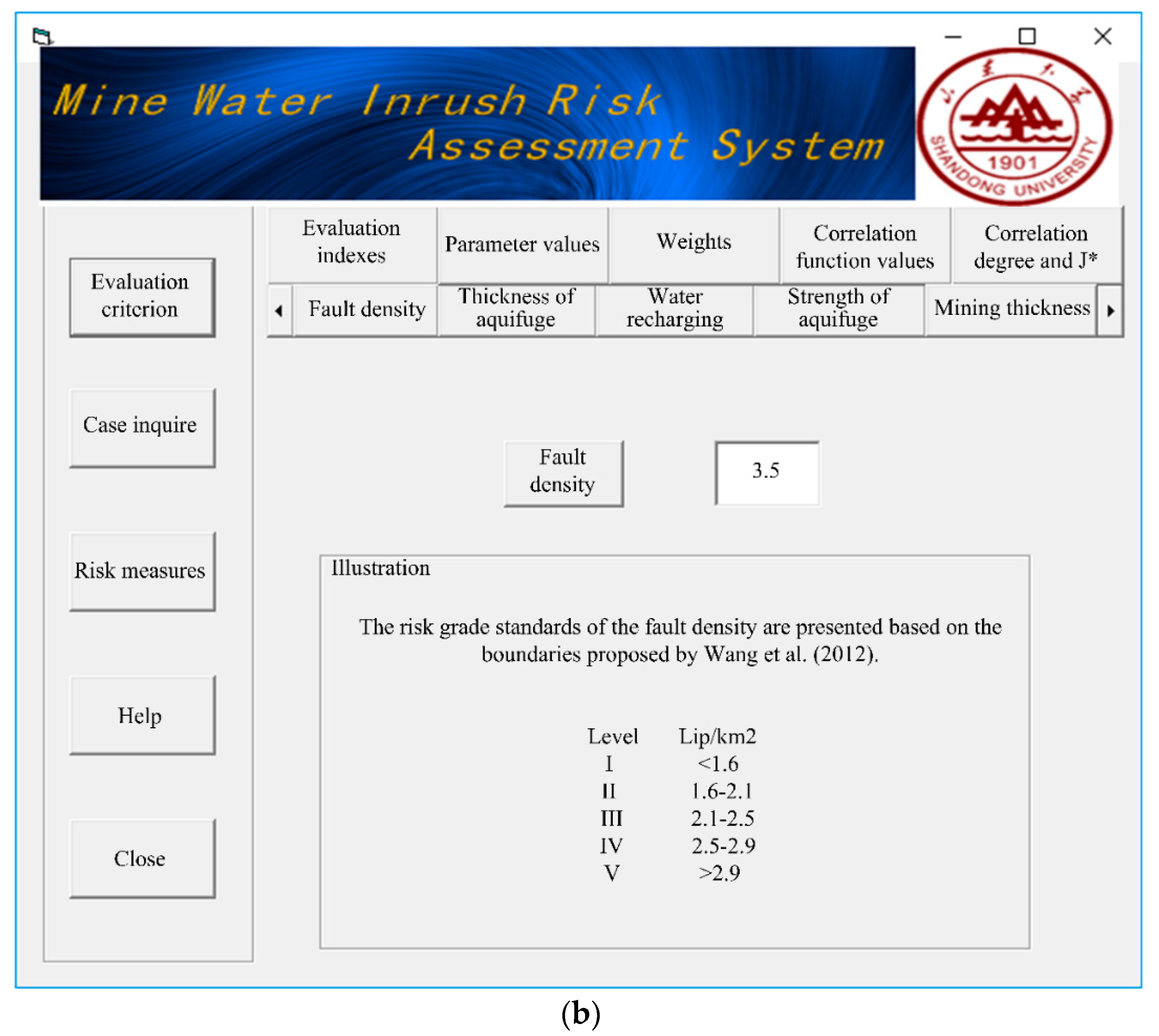
In this system, according to these 11 evaluation indexes, the risk of mine water inrush is divided into five grades: I, II, III, IV, and V, representing very low risk, low risk, medium risk, high risk, and very high risk, respectively. The risk grade standards of the evaluation indices are presented in Table 1 based on the boundaries proposed by Wang et al. [20].
To facilitate the comparison of different evaluation indicators and scientific induction, the various indices should be normalized. Normalization is a dimensionless processing method that makes the absolute value of the physical system value a relative value relation. If the risk level increases with the index, one can use Equation (1) for the calculation. However, Equation (2) could be used for the calculation. The non-dimensional index grade division is shown in Table 2.
3.1.3. Data Input
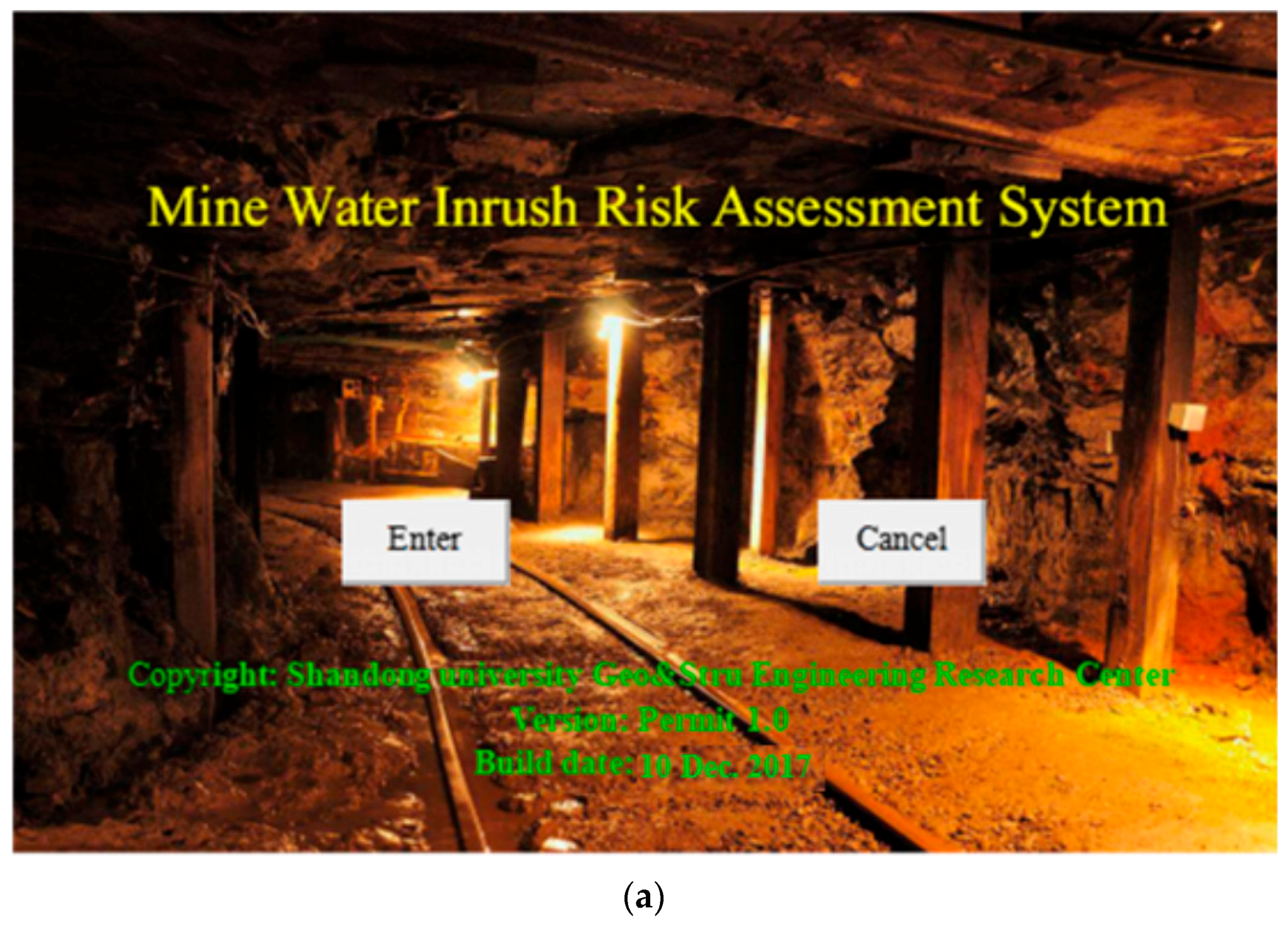
Parameter values of each evaluation index in a specific project case can be obtained according to the above analysis. As all the parameter values are input to the system, the mine water inrush risk can be produced by a certain calculation process that will be outlined in the input program in this research. Interfaces of the software system are shown in Figure 2.
3.2. Analysis Program
The risk grade of mine water inrush can be calculated using the parameter value prepared in the input program that emerged intuitively on the main interface. An exhaustive evaluation process and evaluation file can be saved as a reference for further understanding, or for further work on the assessment.
3.2.1. Matter-Element Extension Entropy-Weight Model
Classical Field, Festival Field, and Matter-Element to be Evaluated
Assume
where is the j isomorphic matter–element; is the j evaluation grade; is the i assessment index; and is the value scope of , j = 1, 2, …, m.
where the P is the value of the entire mine; is the codomain of P; and (i = 1,2, …, n; j = 1,2, …, m).
For mine P, the statistical data and analysis results of mine water inrush grade can be expressed by matter-element R.
where vi is the value of each evaluation index ci.
Correlation Function Value
Weight Calculation
Entropy is a measure of the degree of disorder of a system. The larger the entropy, the more chaotic the system (the less information it carries). The smaller the entropy, the more ordered the system (the more information it carries). Information entropy is used to describe the amount of event information on average, so in mathematics information entropy is the expectation of the amount of information contained in the event. For a certain index, the entropy value can be used to judge the degree of the discrete index. The smaller the entropy value, the greater the degree of the discrete index, and the greater the impact (weight) of the index on the comprehensive evaluation. If the entropy value of an index is all equal, the index will not play a role in comprehensive evaluation.
The entropy-weight method is an objective method of weight calculation. The entropy-weight of each assessment index can be calculated by using information entropy based on the degree of variation of each indicator [35,36]. Then, the weight of each index is modified by the method of entropy to obtain a more objective index weight. The results obtained by the entropy-weight method are more accurate and more objective, which can better explain the results compared to other subjective weight calculation methods.
The judgment matrix is constructed according to the above analysis and Equations (9)–(12).
The entropy of each evaluation index is defined according to the improved entropy concept.
Equation (13) is used to calculate the weight of each evaluation index.
Grade Evaluation
The correlation degree of risk grade j is calculated by Equation (14)
where is the relational grade of j.
Then P belongs to grade j0.
Order
where J* is the variable eigenvalue of P.
3.3. Database
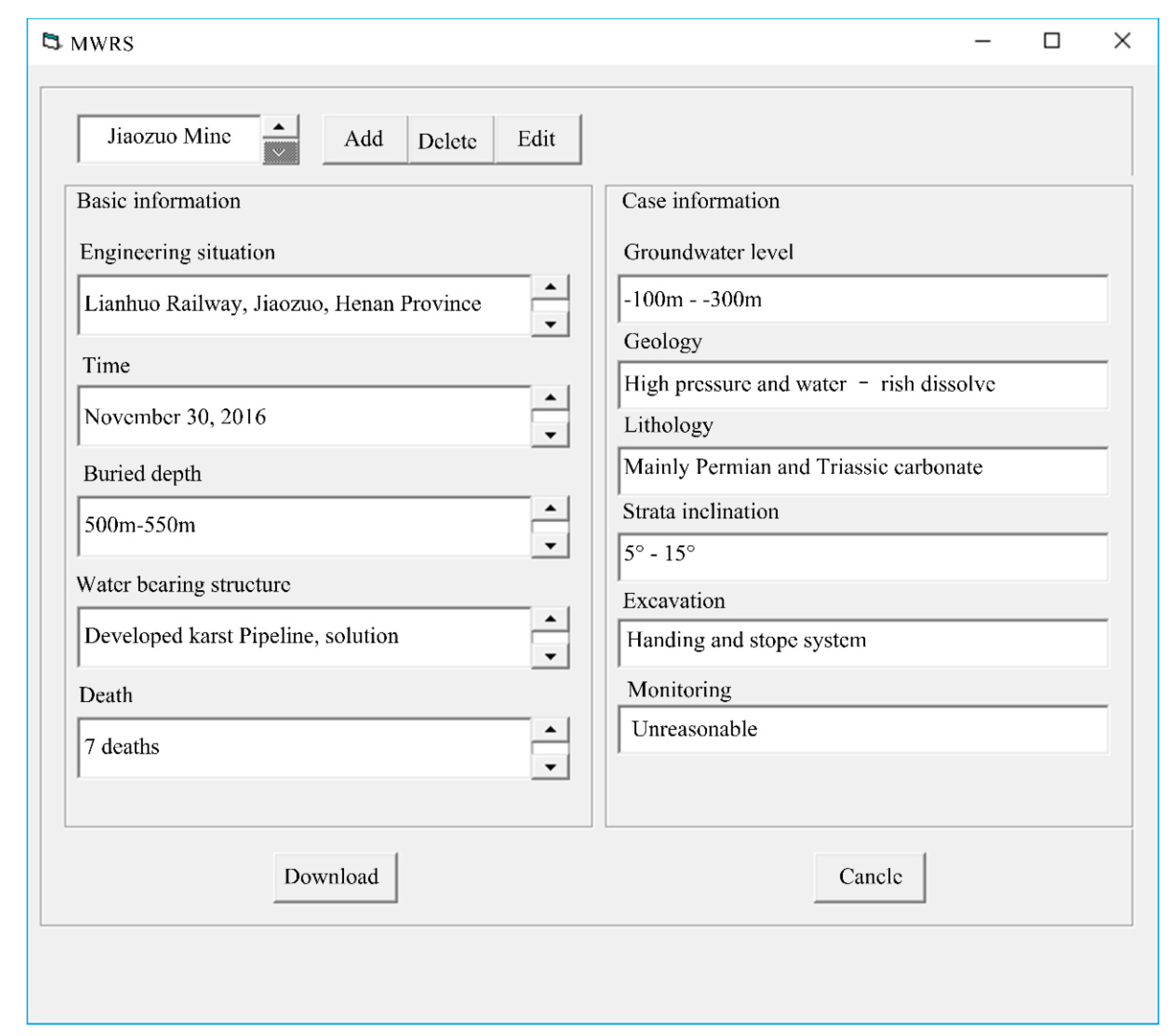
The geological structure, hydrogeological condition, mining effect, and other engineering information are stored completely in the case inquiry of this system. The statistical analysis of the engineering information makes the assessment data more objective and reasonable. The interface of the case inquiry is shown in Figure 3. Control measures corresponding to different risk levels can be ascertained by consulting the assessment rules. The risk-controlling measures are shown in Table 3.
4. Engineering Applications of the System
4.1. Parameter Value
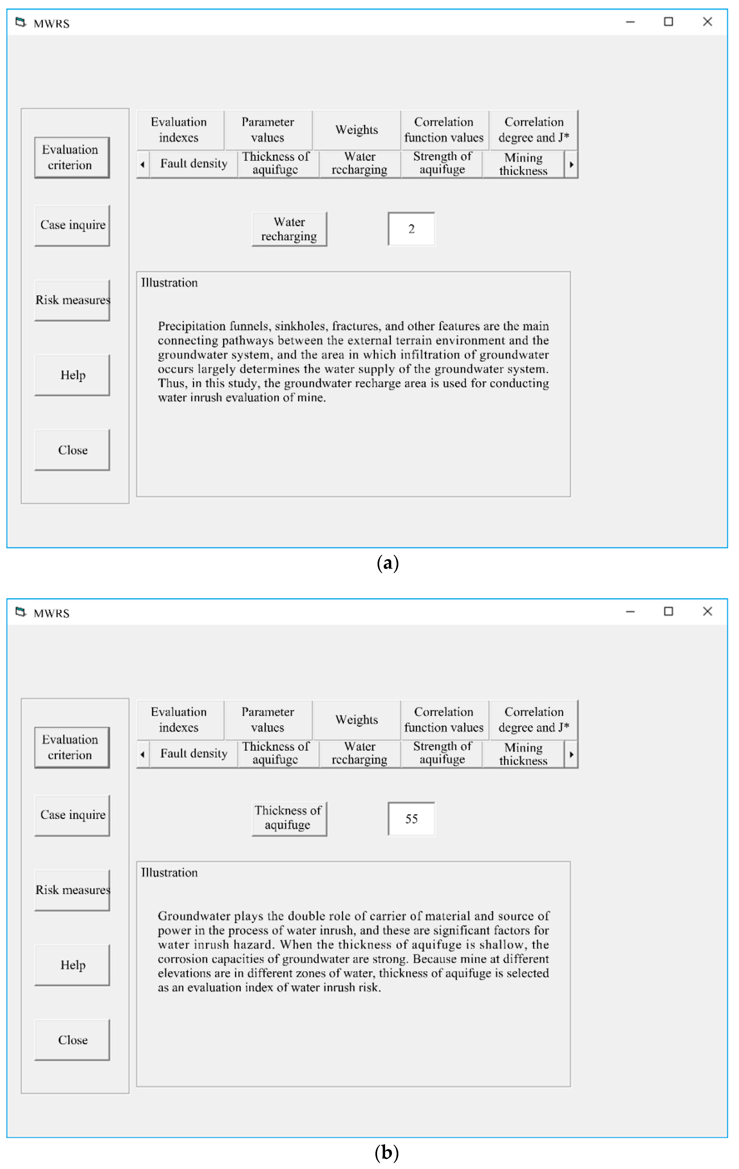
Wang et al. (2012) researched the risk of mine water inrush at the 3612 working face of No. 6 coal seam of the Shanxi Formation in the Huaibei Permian mining area based on secondary fuzzy comprehensive evaluation [20]. The system used the case information provided by Wang et al. (2012) [20] to verify the feasibility of the mine water inrush assessment system and the accuracy of the evaluation. The indices’ values for the risk assessment of mine water inrush were calculated based on the engineering geological and hydrogeological conditions provided by Wang et al. (2012) [20]. The indices’ values for the risk of mine water inrush are shown in Table 4. The input interface of part of the index values is shown in Figure 4.
4.2. Grade of Risk Assessment
Eigen matter–element Rp of the risk grade of mine water inrush was calculated according to Equations (3)–(5) and Table 2.
Correlation function values () for each evaluation grade of mine water inrush were calculated based on Equations (6)–(9).
The greater the grade of index ci, the greater the influence on the risk of mine water inrush. Therefore, ci should be given a greater weight value. The weights of each index ci could be obtained based on Equations (10)–(13).
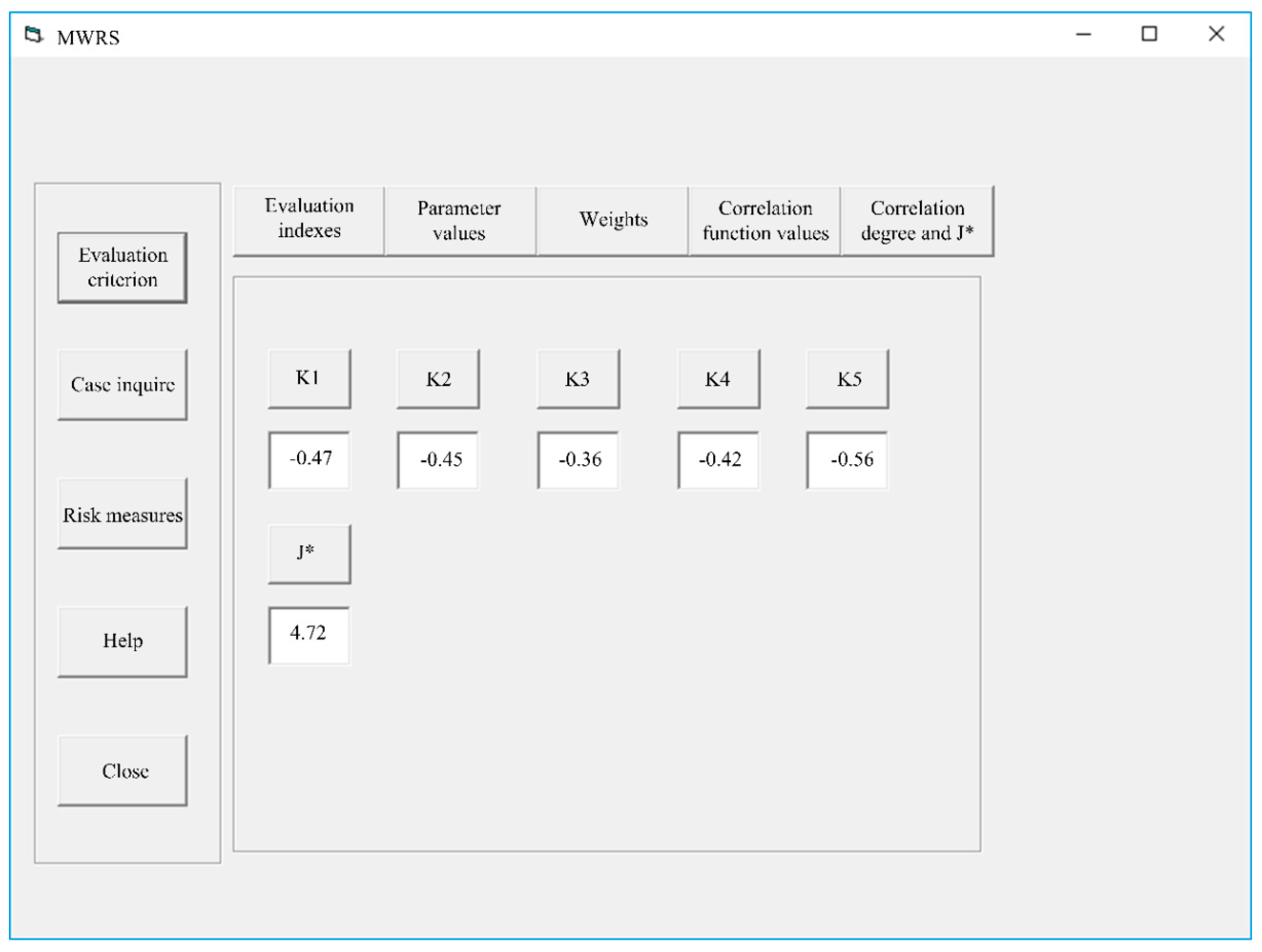
The risk grade of water inrush and the correlation degree of grade j were calculated using Equations (14)–(17). The risk of floor water inrush turned out to be very high and tended to be high in the 3612 working face of No. 6 coal seam of the Shanxi Formation in the Huaibei Permian mining area according to the calculation results of Table 5. The evaluation results agreed with the secondary fuzzy comprehensive evaluation and field-observed results. Evaluation results of this software system are shown in Figure 5.
4.3. Result Analysis
More data were calculated and gathered for further testing to verify the mine water inrush risk assessment system. The indices’ values for these cases are shown in Table 6. The correlation degree and risk grade of each case calculated by the software system are displayed in Table 7. The results derived from the software system and secondary fuzzy comprehensive evaluation and the field-observed results were compared (assume 0 for no occurrence of mine water inrush, and 1 for occurrence of mine water inrush.). The results showed that it was more convenient to acquire the evaluation data, the process of evaluation was simpler and faster, and the evaluation result was more accurate and reasonable (J* = 4.7 means that the grade of the surrounding rock is Grade IV to Grade V, and is closer to Grade V). The corresponding prevention and control measures are given according to the results of the evaluation (see Table 3). However, other evaluation methods can only be used to determine whether water inrush is occurring. This software system provides a powerful tool for systematically assessing the risk of mine water inrush, and the proposed model has practical guiding implications and can be applied in further mining engineering.
5. Conclusions
Risk factors were selected as the assessment indices to evaluate the mine water inrush based on the principles of rationality, operability, and representation, involving fault density, fault-water transmitting ability, fracture development degree, artesian water pressure, watery property of the aquifer, karst development degree, water recharging, thickness of aquifuge, strength of aquifuge, mining thickness, and mining depth. The system was used to normalize the evaluation index, which made the evaluation index comparable, so that the risk grade of mine water inrush obtained was more accurate.
A synthetic evaluation system was proposed to evaluate the risk of water inrush in coal mining. The matter-element extension theory and the entropy-weight method were combined for risk assessment. The entropy-weight was applied to calculate the weight of the evaluation index of the risk grade of mine water inrush, which reduced the influence of human subjective factors, realized the quantification of qualitative indicators, improved the reliability of evaluation indicators, and provided some reference for mine water inrush safety management.
According to the data of the 3612 working face of No. 6 coal seam of the Shanxi Formation in the Huaibei Permian mining area provided by Wang et al. [20], a case study was conducted. The mine water inrush risk of more engineering practices was assessed. The evaluation results of the software system agreed well with the field-observed results. Results from the proposed model and secondary fuzzy comprehensive evaluation method were also compared, and they indicated that it was accurate and feasible to assess the risk of floor water inrush using the proposed mine water inrush risk assessment system.
Author Contributions
Data curation, L.L.; Formal analysis, S.S.; Funding acquisition, S.S. and L.L.; Investigation, S.S.; Methodology, X.X.; Resources, Z.W.; Software, Z.W. and Z.Z.; Supervision, Z.W., Z.Z. and S.S.; Validation, Z.W. and Z.Z.; Writing—original draft, X.X.; Writing—review and editing, S.S. and Z.W.
Funding
This research was funded by National Natural Science Foundation of China (Grant No. 51609129, 51709159, 51679131, 51709160), State key laboratory for Mine disaster prevention and control, cultivation base co-built by province and ministry of Shandong university of science and technology (Grant No. MDPC201707, MDPC201802), Shandong postdoctoral innovation project special Foundation (Grant No. 201502025, 201702014), China Postdoctoral Science Foundation (Grant No. 2017T100492, 2017M612273), The Fundamental Research Funds of Shandong University (Grant No. 2016GN026), The Project of Special Fund for Science and Technology of Water Resources Department of Guizhou Province (Project No. KT201804), Shandong Province Natural Science Foundation of China (ZR2017QEE009).
Conflicts of Interest
The authors declare no conflict of interest.
References
- Khademi Hamidi, J.; Shahriar, K.; Rezai, B.; Bejari, H. Application of fuzzy set theory to rock engineering classification systems: An illustration of the rock mass excavability index. Rock Mech. Rock Eng. 2009, 43, 335–350. [Google Scholar] [CrossRef]
- Xiang, H.; Wenquan, Z.; Dianzhi, J. Assessment method of water-inrush risk induced by fault activation and its application research. Procedia Eng. 2011, 26, 441–448. [Google Scholar] [CrossRef]
- Meng, Z.; Li, G.; Xie, X. A geological assessment method of floor water inrush risk and its application. Eng. Geol. 2012, 143–144, 51–60. [Google Scholar] [CrossRef]
- Lin, D.K.; Shen, F.M.; Liao, S.J. Research on safety evaluation of coal mine water Hazard based on extension theory and interval empowerment. Saf. Environ. Eng. 2015, 22, 124–128. [Google Scholar]
- Li, B.; Chen, Y. Risk assessment of coal floor water inrush from underlying aquifers based on GRA–AHP and its application. Geotech. Geol. Eng. 2015, 34, 143–154. [Google Scholar] [CrossRef]
- Ruan, Z.E.; Li, C.P.; Li, Z.X. Risk assessment of underground mine water inrush based on improved analytic hierarchy process. Ind. Saf. Environ. Prot. 2016, 42, 47–95. [Google Scholar]
- Polak, K.; Różkowski, K.; Czaja, P. Causes and effects of uncontrolled water inrush into a decommissioned mine shaft. Mine Water Environ. 2015, 35, 128–135. [Google Scholar] [CrossRef]
- Yang, B.B.; Sui, W.H.; Duan, L.H. Risk assessment of water inrush in an underground coal mine based on GIS and fuzzy set theory. Mine Water Environ. 2017, 36, 617–627. [Google Scholar] [CrossRef]
- Xu, X.; Sun, W.B. Application of AHP on risk evaluation for coal mine water-inrush. Coal Technol. 2017, 35, 143–144. [Google Scholar]
- Qiu, M.; Shi, L.; Teng, C.; Zhou, Y. Assessment of water inrush risk using the fuzzy delphi analytic hierarchy process and grey relational analysis in the LiangZhuang coal mine, China. Mine Water Environ. 2016, 36, 39–50. [Google Scholar] [CrossRef]
- Zhou, Q.; Herrera-Herbert, J.; Hidalgo, A. Predicting the risk of fault-induced water inrush using the adaptive neuro-fuzzy inference system. Minerals 2017, 7, 55. [Google Scholar] [CrossRef]
- Delgado, A.; Romero, I. Environmental conflict analysis using an integrated grey clustering and entropy-weight method: A case study of a mining project in Peru. Environ. Model. Softw. 2015, 77, 108–121. [Google Scholar]
- Li, X.X.; Wang, K.S.; Liu, L.W.; Xin, J.; Yang, H.R.; Gao, C.Y. Application of the entropy weight and topsis method in safety evaluation of coal mines. Procedia Eng. 2011, 26, 2085–2091. [Google Scholar] [CrossRef]
- Rodríguez, C.; Leiva-Aravena, E.; Serrano, J.; Leiva, E. Occurrence and removal of copper and aluminum in a Stream confluence affected by acid mine drainage. Water 2018, 10, 516. [Google Scholar] [CrossRef]
- Qi, Y.; Li, M.; Li, K.; Yeh, T.C.J. Spatiotemporal development of mine water inrush and its mechanism—A case study in Ganhe coal mine, Shanxi, China. Arab. J. Geosci. 2017, 10, 433–441. [Google Scholar] [CrossRef]
- Ljiljana, M.P.; Javier, G.T.; Enrique, Q.; Kazimierz, L. A new simple methodology for evaluation of explosion risk in underground coal mines. J. Loss Prev. Process Ind. 2013, 26, 1524–1529. [Google Scholar]
- Li, L.P.; Zhou, Z.Q.; Li, S.C.; Xu, Z.H.; Shi, S.S. An attribute synthetic evaluation system for risk assessment of floor water inrush in coal mines. Mine Water Environ. 2015, 34, 288–294. [Google Scholar] [CrossRef]
- Odintsev, V.N.; Miletenko, N.A. Water inrush in mines as a consequence of spontaneous hydrofracture. J. Min. Sci. 2015, 51, 423–434. [Google Scholar] [CrossRef]
- Yin, S.X.; Zhang, J.C.; Liu, D.M. A study of mine water inrushes by measurements of in situ stress and rock failures. Nat. Hazard. 2015, 79, 1961–1979. [Google Scholar] [CrossRef]
- Wang, Y.; Yang, W.F.; Li, M.; Liu, X. Risk assessment of floor water inrush in coal mines based on secondary fuzzy comprehensive evaluation. Int. J. Rock Mech. Min. Sci. 2012, 52, 50–55. [Google Scholar] [CrossRef]
- Zhu, B.B.; Li, W.; Peng, Y.X.; Zhou, W.W.; Chen, C.H. Risk assessment of water inrush in tunnel through water-rich fault. Geotech. Geol. Eng. 2018, 36, 317–326. [Google Scholar] [CrossRef]
- Hu, X.Y.; Wang, L.G.; Lu, Y.L.; Yu, M. Analysis of insidious fault activation and water inrush from the mining floor. Int. J. Min. Sci. Technol. 2014, 24, 477–483. [Google Scholar] [CrossRef]
- Zhang, S.C.; Guo, W.J.; Li, Y.Y.; Sun, W.B.; Yin, D.W. Experimental simulation of fault water inrush channel evolution in a coal mine floor. Mine Water Environ. 2017, 36, 443–451. [Google Scholar] [CrossRef]
- Liu, R.; Li, B.; Jiang, Y. A fractal model based on a new governing equation of fluid flow in fractures for characterizing hydraulic properties of rock fracture networks. Comput. Geotech. 2016, 75, 57–68. [Google Scholar] [CrossRef]
- Li, B.; Liu, R.; Jiang, Y. Influences of hydraulic gradient, surface roughness, intersecting angle, and scale effect on nonlinear flow behavior at single fracture intersections. J. Hydrol. 2016, 538, 440–453. [Google Scholar] [CrossRef]
- Li, Z.H.; Feng, G.R.; Zhai, C.Z. Study on “triangle” water-inrush mode of strong water-guide collapse column. J. Cent. South Univ. 2016, 23, 2402–2409. [Google Scholar] [CrossRef]
- Chen, L.W.; Qin, Y.; Gui, H.R.; Zhang, S.L. Analysis on probability of water inrush and quicksand in different mining sequences under an unconsolidated alluvium aquifer by fluid-solid coupling theory. J. Coal Sci. Eng. China 2012, 18, 60–66. [Google Scholar] [CrossRef]
- Shi, L.Q.; Qiu, M.; Wei, W.X.; Xu, D.J.; Han, J. Water inrush evaluation of coal seam floor by integrating the water inrush coefficient and the information of water abundance. Int. J. Min. Sci. Technol. 2014, 24, 677–681. [Google Scholar] [CrossRef]
- Angelstam, P.; Vladimir, N.; Marine, E. Transitioning from soviet wood mining to sustainable forest management by intensification: Are tree growth rates different in northwest Russia and Sweden? Forestry 2017, 90, 292–303. [Google Scholar] [CrossRef]
- Farhad, H.; PulokKanti, D.; Muzemder, A.S.H. Monitoring the underground roadway water quantity and quality for irrigation use around the Barapukuria Coal Mining Industry, Dinajpur, Bangladesh. Groundwater Sustain. Dev. 2017, 4, 23–24. [Google Scholar] [CrossRef]
- Gui, H.R.; Song, X.M.; Lin, M.L. Water-inrush mechanism research mining above karst confined aquifer and applications in North China coalmines. Arab. J. Geosci. 2017, 10, 180–189. [Google Scholar] [CrossRef]
- Bai, H.B.; Miao, X.X. Hydrogeological characteristics and mine water inrush prevention of late Paleozoic coalfields. J. China Univ. Min. Technol. 2016, 45, 1–10. [Google Scholar]
- Peng, L.J.; Yang, X.J.; Sun, X.M. Analysis and control on anomaly water inrush in roof of fully-mechanized mining field. Min. Sci. Technol. China 2011, 21, 89–92. [Google Scholar]
- Li, C.P.; Li, J.J.; Li, Z.X.; Hou, D.Y. Establishment of spatiotemporal dynamic model for water inrush spreading processes in underground mining operations. Saf. Sci. 2013, 55, 45–52. [Google Scholar] [CrossRef]
- Pathak, S.; Ojha, C.S.P.; Zevenbergen, C.; Garg, R.D. Ranking of storm water harvesting sites using heuristic and non-heuristic weighing approaches. Water 2017, 9, 710. [Google Scholar] [CrossRef]
- Ni, L.; Jiang, J.C.; Pan, Y.; Wang, Z.R. Leak location of pipelines based on characteristic entropy. J. Loss Prev. Process Ind. 2014, 30, 24–36. [Google Scholar] [CrossRef]
Figure 1.
Basic flowchart of the program.

Figure 2.
Interfaces of the software system: (a) login interface; (b) main calculating interface.


Figure 3.
Interface of case inquiry.

Figure 4.
Input interface of part of the index values: (a) the input interface of the water recharging value; (b) the input interface of the thickness of the aquifuge value.
Figure 4.
Input interface of part of the index values: (a) the input interface of the water recharging value; (b) the input interface of the thickness of the aquifuge value.

Figure 5.
The evaluation results.


Table 1.
Grade standards of the evaluation indexes.
| Evaluation Indices | Risk Grades of Mine Water Inrush | ||||
|---|---|---|---|---|---|
| Very High | High | Medium | Low | Very Low | |
| c1 (lip/km2) | >2.9 | 2.9~2.5 | 2.5~2.1 | 2.1~1.6 | <1.6 |
| c2 | 4~5 | 3~4 | 2~3 | 1~2 | <1 |
| c3 | 4~5 | 3~4 | 2~3 | 1~2 | <1 |
| c4 (MPa) | >3.7 | 3.7~3 | 3~2 | 2~1.2 | <1.2 |
| c5 | 4~5 | 3~4 | 2~3 | 1~2 | <1 |
| c6 | 4~5 | 3~4 | 2~3 | 1~2 | <1 |
| c7 | 4~5 | 3~4 | 2~3 | 1~2 | <1 |
| c8 (m) | <31 | 31~49 | 49~74 | 74~93 | >93 |
| c9 (MPa) | <1.4 | 1.4~1.7 | 1.7~2.1 | 2.1~2.4 | >2.4 |
| c10 (m) | >2.1 | 2.1~1.6 | 1.6~1.4 | 1.4~1.2 | <1.2 |
| c11 (m) | >750 | 750~650 | 650~550 | 550~450 | <450 |
Table 2.
Normalized standard of classification.
| Evaluation Indices | Risk Grades of Mine Water Inrush | ||||
|---|---|---|---|---|---|
| Very High | High | Medium | Low | Very Low | |
| c1 (lip/km2) | 0.500~1.000 | 0.344~0.500 | 0.219~0.344 | 0.094~0.219 | 0.000~0.094 |
| c2 | 0.800~1.000 | 0.600~0.800 | 0.400~0.600 | 0.200~0.400 | 0.000~0.200 |
| c3 | 0.800~1.000 | 0.600~0.800 | 0.400~0.600 | 0.200~0.400 | 0.000~0.200 |
| c4 (MPa) | 0.700~1.000 | 0.500~0.700 | 0.250~0.500 | 0.075~0.250 | 0.000~0.075 |
| c5 | 0.800~1.000 | 0.600~0.800 | 0.400~0.600 | 0.200~0.400 | 0.000~0.200 |
| c6 | 0.800~1.000 | 0.600~0.800 | 0.400~0.600 | 0.200~0.400 | 0.000~0.200 |
| c7 | 0.800~1.000 | 0.600~0.800 | 0.400~0.600 | 0.200~0.400 | 0.000~0.200 |
| c8 (m) | 0.690~1.000 | 0.510~0.690 | 0.260~0.510 | 0.070~0.260 | 0.000~0.070 |
| c9 (MPa) | 0.462~1.000 | 0.346~0.462 | 0.192~0.346 | 0.077~0.192 | 0.000~0.077 |
| c10 (m) | 0.520~1.000 | 0.440~0.520 | 0.360~0.440 | 0.160~0.360 | 0.000~0.160 |
| c11 (m) | 0.438~1.000 | 0.312~0.438 | 0.188~0.312 | 0.063~0.188 | 0.000~0.063 |
Table 3.
Risk measures.
| Grade | Risk-Controlling Measures |
|---|---|
| I | Normal construction. |
| II | Normal construction, construction organization should strengthen, monitor, and assign managers to supervise safety production. |
| III | Stop construction, construction organization should take precautionary measures in time according to the field situation. |
| IV | Stop construction, construction organization should take precautionary measures in time and make design changes. |
| V | Stop construction, construction organization should take precautionary measures, make a construction rectification, and convene assembly of experts for large-scale design changes. |
Table 4.
Indices’ values for risk of mine water inrush.
| Evaluation Indices | c1 (lip/km2) | c2 | c3 | c4 (MPa) | c5 | c6 | c7 | c8 (m) | c9 (MPa) | c10 (m) | c11 (m) |
|---|---|---|---|---|---|---|---|---|---|---|---|
| Value | 3.5 | 1 | 1 | 3.14 | 2 | 2 | 2 | 55 | 1.4 | 3 | 450 |
Table 5.
The sample of comprehensive extensive evaluation.
| Sample | Correlation Degree | Evaluation Results | |||||
|---|---|---|---|---|---|---|---|
| K1 | K2 | K3 | K4 | K5 | J* | Matter–Element Extension Entropy–Weight Theory | |
| S1 | −0.47 | −0.45 | −0.36 | −0.42 | −0.56 | 4.72 | V→IV |
Table 6.
Indices values of engineering applications.
| Coalfield | c1 | c2 | c3 | c4 | c5 | c6 | c7 | c8 | c9 | c10 | c11 |
|---|---|---|---|---|---|---|---|---|---|---|---|
| A mine in Jiaozuo, Henan | 1.54 | 3 | 5 | 1.9 | 5 | 5 | 4 | 28.5 | 2.1 | 5.5 | 550 |
| 2137 working face in ZhaogeZhuang mine in Hebei Kailuan | 0.3 | 1 | 3 | 10 | 5 | 2 | 1 | 130 | 2.4 | 9 | 1100 |
| 9901 working face in Taoyang mine south of Feicheng mining | 3.52 | 4 | 3 | 0.6 | 5 | 2 | 2 | 9 | 1.6 | 1.32 | 100 |
| 8634 working face in Hebei Fengfeng Yangqu mine | 0.6 | 1 | 2 | 3.9 | 5 | 5 | 5 | 57 | 1.9 | 1.43 | 355 |
| A working face in the west of Feicheng mine | 2.56 | 4 | 5 | 2.85 | 4 | 4 | 5 | 29.66 | 2.6 | 1.5 | 280 |
Table 7.
Risk assessment results of each engineering practice.
| Coalfield | Synthetic Attribute Measures | Matter–Element Extension–Entropy Weight Theory | Evaluation Value in Wang et al. (2012) [20] | Actual Value | |||||
|---|---|---|---|---|---|---|---|---|---|
| K1 | K2 | K3 | K4 | K5 | J* | Risk | |||
| A mine in Jiaozuo, Henan | −0.39 | −0.13 | −0.02 | −0.11 | −0.38 | 3.64 | IV→III | 1 | 1 |
| 2137 working face in Zhaogezhaung mine in Hebei Kailuan | −0.35 | −0.10 | −0.02 | −0.05 | −0.28 | 2.34 | III→II | 0 | 0 |
| 9901 working face in Taoyang mine south of Feicheng mining | −0.39 | −0.24 | −0.12 | −0.21 | −0.39 | 3.73 | IV→III | 1 | 1 |
| 8634 working face in Hebei Fengfeng Yangqu mine | −0.25 | −0.24 | −0.32 | −0.01 | −0.15 | 2.26 | III→II | 0 | 0 |
| A working face in the west of Feicheng mine | −0.52 | −0.14 | −0.19 | −0.28 | −0.29 | 3.65 | IV→III | 1 | 1 |
© 2018 by the authors. Licensee MDPI, Basel, Switzerland. This article is an open access article distributed under the terms and conditions of the Creative Commons Attribution (CC BY) license (http://creativecommons.org/licenses/by/4.0/).
Share and Cite
MDPI and ACS Style
Shi, S.; Xie, X.; Wen, Z.; Zhou, Z.; Li, L.; Song, S.; Wu, Z. Intelligent Evaluation System of Water Inrush in Roadway (Tunnel) and Its Application. Water 2018, 10, 997. https://doi.org/10.3390/w10080997
AMA Style
Shi S, Xie X, Wen Z, Zhou Z, Li L, Song S, Wu Z. Intelligent Evaluation System of Water Inrush in Roadway (Tunnel) and Its Application. Water. 2018; 10(8):997. https://doi.org/10.3390/w10080997
Chicago/Turabian StyleShi, Shaoshuai, Xiaokun Xie, Zhijie Wen, Zongqing Zhou, Liping Li, Shuguang Song, and Zhonghu Wu. 2018. "Intelligent Evaluation System of Water Inrush in Roadway (Tunnel) and Its Application" Water 10, no. 8: 997. https://doi.org/10.3390/w10080997
Note that from the first issue of 2016, this journal uses article numbers instead of page numbers. See further details here.